
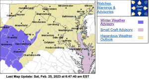
Some lower elevations have been removed from the advisory.
VAZ019-024-035-251600-
/O.CAN.KRNK.WW.Y.0010.000000T0000Z-230225T1900Z/
Alleghany VA-Rockbridge-Amherst-
950 AM EST Sat Feb 25 2023
…WINTER WEATHER ADVISORY IS CANCELLED…
Temperatures have warmed into the upper 30s to around 40. Icing is
no longer expected… just a cold rain mixed with sleet at times.
WINTER WEATHER ADVISORY
URGENT - WINTER WEATHER MESSAGE
National Weather Service Baltimore MD/Washington DC
401 AM EST Sat Feb 25 2023

VAZ503-504-507-508-WVZ505-506-251715-
/O.CON.KLWX.WW.Y.0012.230225T1300Z-230225T2100Z/
Western Highland-Eastern Highland-Northern Virginia Blue Ridge-
Central Virginia Blue Ridge-Western Pendleton-Eastern Pendleton-
401 AM EST Sat Feb 25 2023

...WINTER WEATHER ADVISORY REMAINS IN EFFECT FROM 8 AM THIS
MORNING TO 4 PM EST THIS AFTERNOON...

* WHAT...Mixed precipitation expected. Total snow and sleet
  accumulations of a coating to around one inch and ice
  accumulations of a light glaze to one tenth of an inch.

* WHERE...Highland County Virginia, Pendleton County West
  Virginia, and the central and northern Virginia Blue Ridge.

* WHEN...From 8 AM to 4 PM EST Saturday. A mixture of light snow,
  sleet, and freezing rain will overspread the area between 7 AM
  and 10 AM. Precipitation will end between 1 PM and 4 PM.

* IMPACTS...Very slippery sidewalks, roads and bridges are
  possi
URGENT - WINTER WEATHER MESSAGE
National Weather Service Baltimore MD/Washington DC
401 AM EST Sat Feb 25 2023

VAZ025-026-251715-
/O.EXA.KLWX.WW.Y.0012.230225T1300Z-230225T2100Z/
Augusta-Rockingham-
401 AM EST Sat Feb 25 2023

...WINTER WEATHER ADVISORY IN EFFECT FROM 8 AM THIS MORNING TO
4 PM EST THIS AFTERNOON...

* WHAT...Mixed precipitation expected. A coating of snow and
  sleet. A light glaze of ice from freezing rain is expected along
  the ridges above 2,000 feet.

* WHERE...Augusta and Rockingham Counties.

* WHEN...From 8 AM to 4 PM EST Saturday. A mixture of light snow,
  sleet, and rain will overspread the area between 8 and 10 AM
  this morning. Precipitation will end between 1 PM and 4 PM this
  afternoon. The rain is expected to freeze on elevated surfaces,
  mainly along the ridges above 2,000 feet.

* IMPACTS...Very slippery sidewalks, roads and bridges are
  possible.

PRECAUTIONARY/PREPAREDNESS ACTIONS...

Slow down and use caution while traveling.

When venturing outside, watch your first few steps taken on
steps, sidewalks, and driveways, which could be icy and slippery,
increasing your risk of a fall and injury.
ble. PRECAUTIONARY/PREPAREDNESS ACTIONS... Slow down and use caution while traveling. When venturing outside, watch your first few steps taken on steps, sidewalks, and driveways, which could be icy and slippery, increasing your risk of a fall and injury.
URGENT - WINTER WEATHER MESSAGE
National Weather Service Blacksburg VA
438 AM EST Sat Feb 25 2023

VAZ019-020-024-035-WVZ507-508-251745-
/O.CON.KRNK.WW.Y.0010.230225T1000Z-230225T1900Z/
Alleghany VA-Bath-Rockbridge-Amherst-Eastern Greenbrier-
Western Greenbrier-
Including the cities of Clifton Forge, Covington, Hot Springs,
Lexington, Buena Vista, Amherst, Lewisburg,
White Sulphur Springs, Quinwood, Duo, and Rainelle
438 AM EST Sat Feb 25 2023

...WINTER WEATHER ADVISORY REMAINS IN EFFECT UNTIL 2 PM EST THIS
AFTERNOON...

* WHAT...Mixed precipitation expected. Total snow and sleet accumulations
  of up to one inch and ice accumulations of a light glaze.

* WHERE...Portions of the Alleghany Highlands, southern Shenadoah
  Valley, and southeast West Virginia.

* WHEN...Until 2 PM EST this afternoon.

* IMPACTS...Slick spots on bridges, overpasses and sidewalks
  possible.


PRECAUTIONARY/PREPAREDNESS ACTIONS...

Slow down and use caution while driving. Also be careful if
venturing outside. Sidewalks, decks, and parking lots could be
slick.

Please report snow, sleet or ice accumulations via email at
rnk.skywarn@noaa.gov or by calling the National Weather Service
toll free at...1...866...2 1 5...4 3 2 4. Leave a message with
your observation and the specific location where it occurred. You
can also post your report to National Weather Service Blacksburg
Facebook page and on Twitter.

The latest road conditions for the state you are calling from can
be obtained by calling 5 1 1.
