REFRESH Nelson County Life Magazine HERE
Updated @ 11:13 AM EDT for wind advisory cancellation.


Forecast By Tommy Stafford – Nelson County Life Magazine
LISTEN TO TODAY’S WEATHER BY PRESSING THE BUTTON.
Photography By Tommy Stafford
Nelson County Life Magazine ©2008
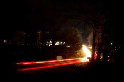
Rainy Night In Nelson
Greenfield, Virginia

Today’s weather and audiocast is brought to you exclusively by:

I remember when my folks tried to get me to eat all of the good stuff out of the garden. Nahhh, that wasn’t me back in those days. Peanut butter, you bet! It was simpler then, and we didn’t have to worry where the peanut butter came from or your produce. Not anymore. Don’t get me wrong, groceries have their place, but wouldn’t you rather have food that you know where it comes from. Enter Ken & Yvonne Harris at a.m. Fog on the Nelson-Albemarle County Line along Route 151. They grow and sell about as close to the farm as you can get.
When you stop by you’ll find:
-Hydroponic tomatoes and cucumbers
-On Farm & Locally Grown Lettuce
-Local, organically Raised Farm Eggs
-Local “Happy Steer†Hormone and Antibiotic Free Meat
-Local Hormone & Antibiotic Free Chicken
Not to mention all of the other vegetables, annual, and perennial plants along with lots of fruit trees ready for the spring planting! Spring begins this Thursday, can you believe it’s already here!
And coming soon, that new farm market under construction now, featuring hot teas & coffee, muffins, and bread. They’re open now, but be looking for the grand opening of the new and larger farm market in just a few days!
Visit them on the web at www.amfog.net or call them at 540-456-7100.


Click the image above for the ski and slope conditions at Wintergreen Resort.
As of 10 PM EDT Wednesday Evening
–WEDNESDAY’S High / Low at NCL-Nelson County Life Magazine in the Rockfish Valley : 66°/51° – RAIN MARCH: 3.51″ : Past 24 Hours = .39″
–WEDNESDAY’S High / Low at NCL-Wintergreen Nature Foundation on Devil’s Knob @ Wintergreen Mountain : 55°/43° – RAIN MARCH: 4.48″ : Past 24 Hours = .55″
–WEDNESDAY’S High / Low at NCL-Hatcreek Farm on Horseshoe Mountain @ Roseland, VA : °62/49° – RAIN MARCH: 5.84 : Past 24 Hours = .84″
–WEDNESDAY’S High / Low at NCL-Wintergreen Winery @ Beech Grove, VA : 51°/63° – RAIN MARCH: 4.93 : Past 24 Hours = .73″
–WEDNESDAY’S High / Low at NCL-Tiger Fuel @ Lovingston, VA : 65°/49° – RAIN: 0.00″ Monthly Total Currently Unavailable
–WEDNESDAY’S High / Low at NCL-Delfosse Winery & Vineyard @ Faber, VA : 65°/50° – RAIN MARCH: 2.02″ : Past 24 Hours = .33″
–WEDNESDAY’S High / Low at NCL-Mini Tara Vineyards @ Arrington, VA : 62°/53° – RAIN: 0.00 Monthly Total Currently Unavailable
Wednesday started off with a little sunshine and cool, but quickly became cloudy, windy and warm as the day wore on. By late in the day just before dark, rains moved in the area. You can see the cars making their way along the wet roads last night in the photo above. Many locations picked up almost an inch before midnight with some additional rain and even some thunder in the wee morning hours. To date, March has been a good rain month with some of our NCL Weathernet Stations report in excess of 5 inches of rain for the month. This gives us a great start heading into and Spring and Summer!
By late evening last night a Wind Advisory CANCELLED @ 11:13 AM EDT was issued due to gusty winds across the area expected to remain in place for much of the day. You can always see the latest weather alerts affecting our area by looking at the RSS Weather feeds right under the cover photo, on the upper left.
Thursday may start with a sprinkle or two east of the BRP, but quickly end with clearing skies and sun moving in. But look for those gusty NW winds kicking up as high as 45 MPH. We’ll still manage to pull out the upper 50’s in many locations, it just won’t feel very warm with those strong winds. By Thursday night the winds settle down a bit, though gusts to near 30 are still possible before midnight.
By the weekend showers may move in Saturday but temps still mild in the 50’s and Easter looks dry for now with temps in the 50’s as well.
I do want to mention something a colleague of mine forwarded last night. Paul Luke, from up in the DC area, and I worked together in television news years ago back in the mid south, as well as weather. Paul noticed this mention in the NWS HYDROMETEOROLOGICAL PREDICTION CENTER discussion early Wednesday.
PRELIMINARY EXTENDED FORECAST DISCUSSION
NWS HYDROMETEOROLOGICAL PREDICTION CENTER CAMP SPRINGS MD
556 AM EDT WED MAR 19 2008VALID 12Z SUN MAR 23 2008 – 12Z WED MAR 26 2008
…POTENTIAL FOR LATE SEASON SNOWSTORM FROM THE MID ATLANTIC
STATES TO NEW ENGLAND…MODELS ARE CONVERGING TOWARD EAST CYCLOGENESIS DAY 5…WITH THE
00Z GFS AND GEFS MEAN TRENDING STRONGLY TOWARD THE DEVELOPED
SOLUTION INDICATED BY THE LAST SEVERAL RUNS OF THE ECMWF AND ECMWF
ENSEMBLE MEAN. SEVERAL OF THE 00Z GFS ENSEMBLE MEMBERS ARE AS
INTENSE AS THE 00Z ECMWF WITH THIS LOW…WITH A SIMILAR TRACK FROM
SOUTH OF CAPE HATTERAS TO THE ATLANTIC BENCHMARK. TAKEN
LITERALLY…THIS GUIDANCE THREATENS A FOOT OF SNOW FROM NEAR
RICHMOND NORTHEASTWARD TO BOSTON…INCLUDING WASHINGTON
DC…PHILADELPHIA…AND NEW YORK CITY. THERE IS PLENTY OF
PRECEDENT FOR LATE SEASON HEAVY SNOWFALL…EVEN OVER THE CAROLINAS
AND SOUTHERN MID ATLANTIC REGION.
I don’t want to get anyone alarmed at this point, these guys have a big reputation of overstating the computer models, but I also don’t want to completely ignore it. So far I see nothing out there in the main stream discussions that coincides with this, but you know as they said, March can be a perfect time for large winter storms. Just keep your eyes and ears open for the next few days and I’ll let you know!
Regional Current Surface Map via wunderground
![]()
Looking 12-24 Hours Ahead


Your Nelson County Life custom area forecast including: Greenfield, Lovingston, Tyro, and Crozet
Thursday- SPRING BEGINS: Becoming sunny & windy.
* Highs Valley: 58-61°
*On the mountains: 41-44°
*Winds: NW 15-20 gusts to 45 MPH
*OVERNIGHT: Clear & colder, windy early. Lows valley: 32-35° : Mountains: 28-31° : Winds: NW 10-15, gusting to 30. Becoming W 5-10 after midnight.
Friday: Mostly sunny & pleasant.
* Highs Valley: 61-64°
*On the mountains: 56-59°
*Winds: W 5-10 MPH
*OVERNIGHT: Becoming mostly cloudy, not as cold. Lows valley: 40-43° : Mountains: 39-42° : Winds: SW 10-15
The weekend look for clouds and scattered showers Saturday with temps in the upper 50’s valley & mountains. Easter Sunday looks dry and partly sunny with temps in the mid 50’s valley and mid 40’s mountains.
Continuing to watch the chance for snow possible Sunday night into Monday. We’ll see how that shapes up over the next 24 hours.
One of our past favorites heard here at NCL, Jeff Vogelgesang, takes us out with Troy Herdman from his On The Lam CD.
Have a great Thursday everyone!


Want to have Jeff & The Honeybirds play at your special event, click on the image above to find out how!
See more about Jeff and his music by clicking here and on his CD covers above.

