REFRESH Nelson County Life Magazine HERE
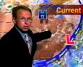
Forecast By Tommy Stafford – Nelson County Life Magazine
LISTEN TO TODAY’S WEATHER BY PRESSING THE BUTTON.
Photography By Tommy Stafford
Nelson County Life Magazine ©2008
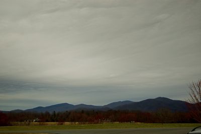
Rain On The Horizon
Afton, Virginia
Today’s weather and audiocast is brought to you exclusively by:

I remember when my folks tried to get me to eat all of the good stuff out of the garden. Nahhh, that wasn’t me back in those days. Peanut butter, you bet! It was simpler then, and we didn’t have to worry where the peanut butter came from or your produce. Not anymore. Don’t get me wrong, groceries have their place, but wouldn’t you rather have food that you know where it comes from. Enter Ken & Yvonne Harris at a.m. Fog on the Nelson-Albemarle County Line along Route 151. They grow and sell about as close to the farm as you can get.
When you stop by you’ll find:
-Hydroponic tomatoes and cucumbers
-On Farm & Locally Grown Lettuce
-Local, organically Raised Farm Eggs
-Local “Happy Steer†Hormone and Antibiotic Free Meat
-Local Hormone & Antibiotic Free Chicken
Not to mention all of the other vegetables, annual, and perennial plants along with lots of fruit trees ready for the spring planting! Spring begins this Thursday, can you believe it’s already here!
And coming soon, that new farm market under construction now, featuring hot teas & coffee, muffins, and bread. They’re open now, but be looking for the grand opening of the new and larger farm market in just a few days!
Visit them on the web at www.amfog.net or call them at 540-456-7100.

Click the image above for the ski and slope conditions at Wintergreen Resort.
–Tuesday’s High / Low at NCL-Nelson County Life Magazine in the Rockfish Valley : 60°/34° – RAIN MARCH: 3.12″
–Tuesday’s High / Low at NCL-Wintergreen Nature Foundation on Devil’s Knob @ Wintergreen Mountain : 45°/31° – RAIN MARCH: 3.93.”
–Tuesday’s High / Low at NCL-Hatcreek Farm on Horseshoe Mountain @ Roseland, VA : °58/32° – RAIN MARCH: 5.00″
–Tuesday’s High / Low at NCL-Wintergreen Winery @ Beech Grove, VA : 56°/36° – RAIN MARCH: 4.20″
–Tuesday’s High / Low at NCL-Tiger Fuel @ Lovingston, VA : 55°/34° – RAIN: 0.00″ Monthly Total Currently Unavailable
–Tuesday’s High / Low at NCL-Delfosse Winery & Vineyard @ Faber, VA : 56°/38° – RAIN MARCH: 1.69″
–Tuesday’s High / Low at NCL-Mini Tara Vineyards @ Arrington, VA : 55°/N/A° – RAIN: 0.00 Monthly Total Currently Unavailable
The photo at the top of today’s weather post is pretty much how the day ended Tuesday. Though we saw some hints of sunshine part of the day, clouds overall prevailed. The sun did come out long enough to warm things up near 60° for most folks.
To our west severe weather has been the story for much of Tuesday and Tuesday night. Flooding and tornadoes were all across the mid-south slowly marching to the east in our direction. There were some scattered showers overnight in our area, but nothing to be concerned with.
Wednesday will be another mostly cloudy day with noticeably warmer temps. I can’t rule out some scattered showers in the morning but the more significant rain will move in after lunch. By late afternoon into Wednesday night, heavier rains will fall and chances for thunderstorms move into the forecast. It will become windy as the the day wears on.
Though severe weather is a possibility as mentioned in the NWS Hazardous Weather Statement:
A STRONG COLD FRONT WILL MOVE ACROSS THE AREA LATE WEDNESDAY
AFTERNOON AND WEDNESDAY EVENING. AHEAD AND ALONG THE COLD
FRONT…SHOWERS AND THUNDERSTORMS ARE EXPECTED. GIVEN STRONG WIND
FIELDS ALOFT…DAMAGING WINDS ARE POSSIBLE IN SHOWERS AND
THUNDERSTORMS. AT THIS TIME…THE MOST LIKELY TIME FOR SEVERE
WEATHER ACROSS THE OUTLOOK AREA IS EXPECTED TO BE BETWEEN 6 PM AND
11 PM WEDNESDAY EVENING.A WIND ADVISORY MAY BE NECESSARY WEDNESDAY NIGHT INTO THURSDAY AS
WIND GUSTS MAY APPROACH 45 MPH.
It doesn’t appear Nelson will be in the bulls eye, but as always I’ll be watching and let you know. Any storms that form, gusty damaging winds would be the main threat.
After Wednesday night we’re quick to clear out and Thursday looks sunny right now for the first day of Spring. Temps will be in the upper 50’s both Thursday & Friday. Rain reenters the forecast again by Friday night into Saturday.
Regional Current Surface Map via wunderground
![]()
Looking 12-24 Hours Ahead

Your Nelson County Life custom area forecast including: Avon, Wintergreen, Montebello, and Faber
Wednesday: Mostly cloudy. Light showers possible early, then rain and scattered thunderstorms afternoon. Warmer & windy.
* Highs Valley: 67-70°
*On the mountains: 60-63°
*Winds: S 15-20 gusts to 35 MPH
*OVERNIGHT: Showers and scattered thunderstorms, ending toward daylight. Lows valley: 45-48° : Mountains: 40-43° : Winds: SW 15-20 & gusty becoming W after midnight.
Thursday – Spring Begins: Early morning clouds and showers east of the BRP, then sunny by noon. Cooler and breezy.
* Highs Valley: 58-61°
*On the mountains: 54-57°
*Winds: NW 15-20 MPH gusts to 35 MPH
*OVERNIGHT: Clear and colder, breezy. Lows valley: 38-41° : Mountains: 34-37° : Winds: NW 10-20 gusting to 30 MPH – becoming W 5-10 after midnight.
The rest of the week Friday is sunny and mild with temps near 60° valley and around mid 50’s mountains. By Friday night rain is possible with lows in the upper 30’s valley and mid 30’s mountains. Scattered light rain continues Saturday with sunny skies working in afternoon. Temps in the upper 50’s. Easter Sunday looks dry with sunny skies and temps mid 50’s valley and upper 40’s mountains.
One of our past favorites heard here at NCL, Jeff Vogelgesang, takes us out with Horse & Buggy from his On The Lam CD.
Have a great Wednesday everyone!

Want to have Jeff & The Honeybirds play at your special event, click on the image above to find out how!


See more about Jeff and his music by clicking here and on his CD covers above.
