UPDATE Nelson County Life Magazine HERE
Weathercast by Tommy Stafford, Nelson County Life Magazine
Updated : 4:30 PM EST 2.21.08
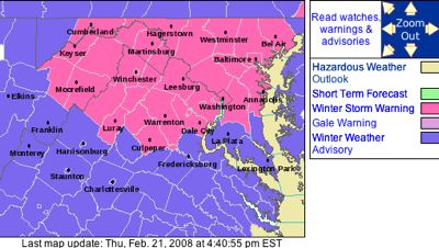
The Winter Storm Watch has now been replaced with a Winter Weather Advisory beginning at 9 PM tonight. Details following within the next hour.


Click on Map Above For Latest Updates
DON’T WANT TO READ TODAY’S WEATHER?
LISTEN BY HITTING THE BUTTON.
BE SURE TO LISTEN TO THIS WEEK’S FEATURED MUSIC ARTIST, ANDY WALDECK OF ARRINGTON AT THE END OF TODAY’S CAST.


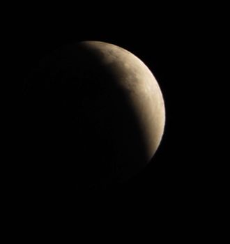
Photography By Ann Strober
For Nelson County Life Magazine ©2008
Lunar Eclipse Over Nelson County
Nellysford, Virginia
–Wednesday’s High / Low at NCL-Nelson County Life Magazine in the Rockfish Valley : 40°/24° – RAIN: 0.00
–Wednesday’s High / Low at NCL-Wintergreen Nature Foundation on Devil’s Knob @ Wintergreen Mountain : 30°/14° – RAIN: 0.00
–Wednesday’s High / Low at NCL-Hatcreek Farm on Horseshoe Mountain @ Roseland, VA : 41°/21° – RAIN: 0.00
–Wednesday’s High / Low at NCL-Wintergreen Winery @ Beech Grove, VA : 40°/25° – RAIN: 0.00
–Wednesday’s High / Low at NCL-Tiger Fuel @ Lovingston, VA : 42°/27° – RAIN: 0.00
–Wednesday’s High / Low at NCL-Delfosse Winery & Vineyard @ Faber, VA : 41°/27° – RAIN: 0.00
–Wednesday’s High / Low at NCL-Mini Tara Vineyards @ Arrington, VA : 40°/27° – RAIN: 0.00


Click the image above for the ski and slope conditions at Wintergreen Resort.


We continue our look and listen this week with Andy Waldeck of Arrington. Be sure to scroll to the bottom to read more about Andy and stick around at the end of today’s audio cast to hear more.
Before I kick off into this very involved forecast, want to say thanks to Ann Strober of Nellysford. Ann sent in today’s pic of last night’s lunar eclipse. I actually tried to grab some shots from here at the office, but Ann’s were much better! Hope you got a look at it, there won’t be another full lunar eclipse until 2010!
The next 24-36 hours will be interesting to say the least. First, a Winter Storm Watch is in effect beginning Thursday evening through late Friday night. That’s a long time for a winter storm watch folks.
In Thursday night’s NWS forecast discussion from the you can see the concern over the developing storm:
“Have decided to issue a Winter Storm Watch for Thursday night
through Friday night. Even though the exact amounts of snow and ice
remain in question…the next storm has the potential to be a high
impact winter event which may affect the morning and
afternoon/evening rush hours on Friday. Overall…believe the models
are too early in scouring out low level cold air. This is not
uncommon in cold air damming situations. Therefore…believe snow
develops Thursday night due to warm advection and isentropic lift.
Snow will begin to mix with sleet and freezing rain Friday
morning…then freezing rain will be the main p-type. There may be a
gradual changeover to rain Friday night…but am not sure this will
be the case. Snow Thursday night/Friday morning could accumulate 1
to 3 inches across the entire County Warning Area…possibly more near the
Pennsylvania border before the changeover to freezing rain. Then
there will be some ice accumulation which could be significant….”
Most of what the forecasters say is self explanatory, but they are concerned about temps at the surface never breaking the freezing mark Friday in our area due to cold air damming. you’ve heard me talk about this before. It’s when cold air below gets pushed up against the mountains and can’t escape keeping a cold pool of air down below. If that occurs when freezing temps are in place and rain is falling, you have ice. It can occur even in the warm months creating low clouds that never want to leave, but it’s a scenario that’s developing over the next day that can make it significant.
It looks like most of the serious winter weather will hold off until late Thursday night. But then we’ll begin to see snow break out eventually changing to sleet and freezing rain, then freezing rain. Friday we look warm only to the lower 30’s for daytime highs, so we may see a prolonged period of icing if all of the factors come together as it looks right now.
By Friday night the freezing rain will linger, but turn to rain showers by Saturday. A warm up, thank goodness, is on the way early next week.
Check back here often on Thursday through Saturday for any advisories or warnings that might be issued. They’ll appear under the cover photo on the upper left in that alerts section. I’ll be monitoring the storm over the next 48 hours as conditions change.
Regional Current Surface Map via wunderground
![]()
Looking Ahead


And for those of you keeping score at home check the detailed numbers at any of our reporting NCL-Weathernet Stations for real up to the minute live weather data and detailed information including highs, lows, wind speeds, rainfall and much, much more, simply use the handy drop down menu on the upper left hand side of your screen.
Your Nelson County Life custom area forecast including: Nellysford, Wintergreen, Schuyler, & Crozet
Wednesday: Mostly sunny early then mostly cloudy by afternoon. Cold.
* Highs Valley: 37-40°
*On the mountains: 27-30°
*Winds: NE-5 MPH becoming SE in the afternoon.
*OVERNIGHT: WINTER STORM WATCH – Snow developing late evening then changing to sleet & freezing rain after midnight 1-3 inch snow & sleet accumulation possible . Lows valley: 20-23° : Mountains: 19-22° : Winds: SE 5-10 MPH
Friday: Winter Storm Watch (possibly a warning by then) continues with sleet & freezing rain early then freezing rain throughout the day. Significant ice accumulation possible.
* Highs Valley: 31-34°
*On the mountains: 28-31°
*Winds: NE-5 MPH
*OVERNIGHT: Light freezing rain lingers. Lows valley: 29-32° : Mountains: 27-30° : Winds: W-5 MPH.
Saturday: Look for rain, sleet and freezing rain early in the mountains, changing to rain in the valley as well. Highs valley mid 40’s and upper 30’s mountains. Overnight lows mid 20’s valley and around 20° mountains. Skies clear Saturday night into Sunday.
Temps warm to the lower 50’s valley by Monday and lower 40’s mountains. Rain is possible again by Tuesday, but temps remains in the 50’s
Andy Waldeck takes us out with Right Direction, a cut from his latest CD, Long on Summer.
Have a great Thursday everyone!
Know your Nelson.COM


Learn more about Andy by clicking here.
Returning to DC, Andy formed his first original music band called Egypt. The idea was simple, Heavy funk riffs ,a la Parliament Funkadelic, mixed with the youthful energy of bands at the time (Living Color, Chili peppers etc.) This band brought the songwriting skills out of Andy, and he began to love the crafting of a song as much as he loved the delivery.
After Egypt broke up, Andy switched to rhythm guitar, re-made himself as a lead singer and Earth to Andy was born. The awesome pop power of this band was easily visible, and within a short year they had signed a management contract with Coran Capshaws ,Red Light Management. New recordings were made, and found their way into the hands and ears of Warner Bros. boutique label Giant Records. A deal was signed and Earth to Andy was on the way. They spent 2 months in L.A. with producer Nick Launay making Chronicle Kings, which brought critical acclaim for its Beatles meets Soundgarden energy.
After several single releases and some solid countywide touring with the likes of Stone Temple Pilots, Fuel, and Tonic. Giant records folded. This was the beginning of the end for Earth to Andy. Unable to get back on their feet, find a new label and continue on productively, they disbanded in 2003. Becoming a solo acoustic artist was the last thing anyone really expected from this consummate rocker/band leader, so that’s what he did. The essence of a song is really felt when it can be played on acoustic guitar,and sung,and understood.
In 2004 Andy released “Offering”, an acoustic EP that showcased the artist in him. Songs are stripped bare of the sonic trimmings, and left naked for the listener to interpret.
Andy has always been about the songs. Early in 2006 he began recording with a new design in mind. A full length, full instrumentation CD with most of the parts being played by him. He wisely enlisted the help of drummer extraordinaire and good friend Nate Brown, who’s work with Andy’s songs has been nothing short of amazing. The process has become a rebirth for Andy. A return to the sounds and grooves that have shaped his musical image. Titled “Long on Summer” and set for fall 2006 release, this work is his finest moment yet, and is sure to bring the attention this artist so rightly deserves.

