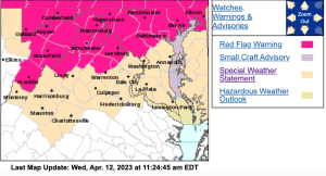
Via NWS : Some parts of the Blue Ridge will have an enhanced chance for the spread of wildfires this afternoon. To the north and northwest there's a Red Flag Warning. Click image for the absolute latest info.
Via NWS : Some parts of the Blue Ridge will have an elevated chance for the spread of wildfires this afternoon. To the north and northwest there’s a Red Flag Warning. Click image for the absolute latest info.
ELEVATED THREAT FOR THE SPREAD OF WILDFIRES THROUGH THE EARLY
EVENING
Special Weather Statement
National Weather Service Baltimore MD/Washington DC
903 AM EDT Wed Apr 12 2023


District of Columbia-Prince Georges-Anne Arundel-Charles-
St. Marys-Calvert-Augusta-Rockingham-Page-Nelson-Albemarle-Greene-
Madison-Rappahannock-Orange-Culpeper-Fairfax-
Arlington/Falls Church/Alexandria-Stafford-Spotsylvania-
King George-Southern Fauquier-Western Highland-Eastern Highland-
Northern Virginia Blue Ridge-Central Virginia Blue Ridge-
Central and Southeast Prince William/Manassas/Manassas Park-
Including the cities of Washington, Bowie, Suitland-Silver Hill,
Clinton, College Park, Greenbelt, Laurel, Camp Springs,
Glen Burnie, Annapolis, Severn, South Gate, Severna Park, Arnold,
Odenton, St. Charles, Waldorf, Lexington Park, California,
Chesapeake Beach, Huntingtown, Dunkirk, North Beach, Lusby,
Prince Frederick, Staunton, Waynesboro, Stuarts Draft,
Harrisonburg, Luray, Shenandoah, Stanley, Lovingston,
Charlottesville, Stanardsville, Madison, Orange, Gordonsville,
Culpeper, Reston, Herndon, Annandale, Centreville, Chantilly,
McLean, Franconia, Arlington, Alexandria, Falls Church, Falmouth,
Fredericksburg, Dahlgren, Turnbull, Hightown, Monterey,
Big Meadows, Wintergreen, Dale City, Manassas, Woodbridge,
Lake Ridge, and Montclair
903 AM EDT Wed Apr 12 2023

...ELEVATED THREAT FOR THE SPREAD OF WILDFIRES THROUGH THE EARLY
EVENING...

West to northwest winds of 10 to 15 mph are expected with gusts
around 20 to 25 mph through this afternoon and relative humidity
values will fall to between 20 and 30 percent. Given recent dry
weather, fuels are very dry. Therefore, an elevated fire danger
will continue until about 8 PM before the winds gradually weaken
and humidity rises.

Outdoor burning is strongly discouraged during this time. Please
refer to your local burn permitting authority on whether you can
burn. If you do burn, use extreme caution and ensure fire
suppression is readily available.

