CANCELLED : Winter Advisory Upgraded to Winter Storm Warning (Includes Wintergreen)

0
558
From NWS : The previously issued Winter Weather Advisory has been upgraded to a Winter Storm Warning along the Blue Ridge Parkway. This includes Wintergreen Resort.

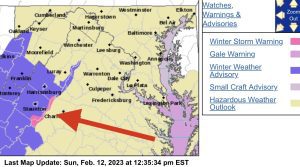
! CANCELLED !

WINTER STORM WARNING
URGENT - WINTER WEATHER MESSAGE
National Weather Service Baltimore MD/Washington DC
1109 AM EST Sun Feb 12 2023

The previously issued Winter Weather Advisory has been upgraded to a Winter Storm Warning for some areas along the Blue Ridge Parkway.This includes Wintergreen Resort.

WINTER STORM WARNING REMAINS IN EFFECT UNTIL MIDNIGHT EST
TONIGHT…

* WHAT…Heavy mixed precipitation. Total snow accumulations of up
to two to three inches, with localized amounts up to five inches
south of Interstate 64. Total ice accumulations of two-tenths to
three-tenths are expected. Winds gusting as high as 35 mph.

* WHERE…Central Virginia Blue Ridge.

* WHEN…Until midnight EST tonight.

* IMPACTS…Plan on slippery road conditions.

* ADDITIONAL DETAILS…Freezing rain is likely while
occasionally mixing with ice pellets. A shift over to all snow
is possible by the evening, becoming locally heavy.

PRECAUTIONARY/PREPAREDNESS ACTIONS…

If you must travel, keep an extra flashlight, food, and water in
your vehicle in case of an emergency.

When venturing outside, watch your first few steps taken on
steps, sidewalks, and driveways, which could be icy and slippery,
increasing your risk of a fall and injury.

WATCH FOR REFREEZING CONDITIONS TONIGHT IN THE SHENANDOAH VALLEY AREA

STAUNTON – (3:15 p.m.) A weather system bringing mostly rain with some sleet and snow continues to move through the Shenandoah Valley and Alleghany Highlands as the afternoon progresses into night on Sunday, February 12. Some icing on trees has been observed in higher elevations.

Motorists should be alert for possible accumulating snow in higher elevations tonight. The rest of the area may experience more rain with some fog followed by a dry pattern with possible refreezing on roadway. Travelers may encounter icy or slushy road conditions, especially on bridges, overpasses and any elevated surface. Tree debris in areas of icing and wind may be possible.

Virginia Department of Transportation Staunton District crews will continue to monitor roads and treat as needed.

When traveling, buckle up and drive to conditions. If wipers are on headlights should also be on.

For winter weather road conditions go to http://www.511Virginia.org, look at the orange bar on the top of the page and click on “Text Views” and then click on “Road Condition Table”. Look at the pull down box that lists all jurisdictions. In this box individual counties can be chosen to view.

On the go? Then visit VDOT’s Free Virginia 511 Tools to get your 511 app for android or iOS. Traffic alerts and traveler information can be obtained by dialing 511.

The VDOT Customer Service Center can be accessed through its mobile friendly website at https://my.vdot.virginia.gov/. Agents are on site 24/7 every day of the year to assist the public. People can also call the VDOT Customer Service Center at 800-FOR- ROAD (800-367-7623).

The Staunton District Snow Page is on the VDOT website under Travel Center Snow Emergency Pages. The Staunton District Twitter feed is at @VaDOTStaunton.

The Staunton District Twitter feed is at @VaDOTStaunton. VDOT can be followed on Facebook, Flickr, Twitter and YouTube. RSS feeds are also available for statewide information. The VDOT Web page is located at http://www.VirginiaDOT.org.

The VDOT Staunton District serves Frederick, Shenandoah, Clarke, Warren, Page, Rockingham, Augusta, Highland, Rockbridge, Alleghany and Bath counties.

#

Road condition definitions:

Severe – drifting or partially blocked road.

Moderate – snow or ice on major portions of the roadway.

Minor – bare pavement except for isolated spots of snow, ice or slush.

LEAVE A REPLY

Please enter your comment!
Please enter your name here