
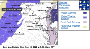
URGENT – WINTER WEATHER MESSAGE…UPDATED
National Weather Service Baltimore MD/Washington DC
252 PM EST Mon Nov 14 2022
Augusta-Rockingham-Northern Virginia Blue Ridge-
Central Virginia Blue Ridge- (Including Wintergreen Resort – scroll below))
252 PM EST Mon Nov 14 2022
…WINTER WEATHER ADVISORY REMAINS IN EFFECT FROM 8 AM TUESDAY TO
MIDNIGHT EST TUESDAY NIGHT…
* WHAT…Wintry mix expected. Total snow and sleet accumulations
of a coating to one inch above 2000 feet. Total ice
accumulation around one to two tenths of an inch above 2000
feet.
* WHERE…Augusta and Rockingham Counties, and Northern Virginia
Blue Ridge and Central Virginia Blue Ridge.
* WHEN…From 8 AM Tuesday to midnight EST Tuesday night. For
elevations above 2000 feet, a wintry mix will overspread the
area most likely between 8 AM and Noon Tuesday. Precipitation
will change to mainly freezing rain Tuesday afternoon before
mixing with rain and ending Tuesday night. For the valleys
most of the precipitation will fall as rain, but a brief
period of sleet is possible at the onset.
* IMPACTS…Plan on slippery road conditions. The hazardous
conditions could impact the morning or evening commute.
* ADDITIONAL DETAILS…Visibility will be reduced to under 1
mile at times in a wintry mix as well as fog for the ridges
above 2000 feet.
PRECAUTIONARY/PREPAREDNESS ACTIONS…
Slow down and use caution while traveling.
When venturing outside, watch your first few steps taken on
steps, sidewalks, and driveways, which could be icy and slippery,
increasing your risk of a fall and injury.
Zone Forecast Product
National Weather Service Baltimore MD/Washington DC
433 PM EST Mon Nov 14 2022
Central Virginia Blue Ridge-
Including the city of Wintergreen
433 PM EST Mon Nov 14 2022
…WINTER WEATHER ADVISORY IN EFFECT FROM 8 AM TUESDAY TO
MIDNIGHT EST TUESDAY NIGHT…
.REST OF THIS AFTERNOON…Mostly sunny. Highs in the lower 40s.
Southeast winds around 5 mph.
.TONIGHT…Partly cloudy. Lows in the upper 20s. Southeast winds
around 5 mph.
.TUESDAY…Rain likely, a slight chance of freezing rain and snow
in the morning, then rain and freezing rain in the afternoon.
Little or no snow accumulation. Ice accumulation of up to one
quarter of an inch. Highs in the mid 30s. East winds around
5 mph. Chance of precipitation near 100 percent.
.TUESDAY NIGHT…Rain with freezing rain likely in the evening,
then a chance of rain after midnight. Lows in the lower 30s.
North winds 5 to 10 mph, becoming northwest with gusts up to
20 mph after midnight. Chance of precipitation near 100 percent.
.WEDNESDAY…Mostly sunny. Highs in the mid 40s. West winds 5 to
10 mph with gusts up to 25 mph.
.WEDNESDAY NIGHT…Mostly clear. Lows in the upper 20s.
.THURSDAY…Sunny. Highs in the upper 30s.
.THURSDAY NIGHT…Mostly clear. Cold with lows in the mid 20s.
.FRIDAY…Sunny. Highs in the mid 30s.
.FRIDAY NIGHT…Mostly clear. Cold with lows in the lower 20s.
.SATURDAY…Sunny. Highs in the mid 30s.
.SATURDAY NIGHT…Mostly clear. Cold with lows in the lower 20s.
.SUNDAY…Sunny. Highs in the mid 30s.
