
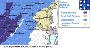
URGENT – WEATHER MESSAGE
National Weather Service Baltimore MD/Washington DC
208 PM EDT Sat Oct 8 2022
Washington-Frederick MD-Carroll-Northern Baltimore-
Extreme Western Allegany-Central and Eastern Allegany-
Northwest Montgomery-Northwest Howard-Northwest Harford-
Frederick VA-Page-Warren-Clarke-Nelson-Albemarle-Greene-Madison-
Rappahannock-Orange-Culpeper-
Prince William/Manassas/Manassas Park-Stafford-Spotsylvania-
Northern Fauquier-Southern Fauquier-Western Loudoun-
Eastern Loudoun-Hampshire-Morgan-Berkeley-Jefferson-Hardy-
Eastern Grant-Western Mineral-Eastern Mineral-
Including the cities of Hagerstown, Frederick, Ballenger Creek,
Eldersburg, Westminster, Reisterstown, Cockeysville, Frostburg,
Cumberland, Germantown, Damascus, Lisbon, Jarrettsville,
Winchester, Luray, Shenandoah, Stanley, Front Royal, Berryville,
Lovingston, Charlottesville, Stanardsville, Madison, Washington,
Orange, Gordonsville, Culpeper, Dale City, Manassas, Woodbridge,
Lake Ridge, Montclair, Falmouth, Fredericksburg, Warrenton,
Turnbull, Purcellville, Leesburg, Ashburn, Sterling, Romney,
Paw Paw, Martinsburg, Charles Town, Shepherdstown, Moorefield,
Petersburg, Elk Garden, Antioch, Keyser, New Creek, Ridgeville,
Russelldale, Headsville, and Fort Ashby
208 PM EDT Sat Oct 8 2022
…FROST ADVISORY REMAINS IN EFFECT FROM MIDNIGHT TONIGHT TO 9 AM
EDT SUNDAY…
* WHAT…Temperatures as low as 34 will result in frost
formation.
* WHERE…Most of western, central, north central, and northern
Maryland, northern and northwest Virginia, and all of the
eastern panhandle of West Virginia.
* WHEN…From midnight tonight to 9 AM EDT Sunday.
* IMPACTS…Frost could kill sensitive outdoor vegetation if
left uncovered.
PRECAUTIONARY/PREPAREDNESS ACTIONS…
Take steps now to protect tender plants from the cold.
URGENT – WEATHER MESSAGE
National Weather Service Baltimore MD/Washington DC
208 PM EDT Sat Oct 8 2022
Northern Virginia Blue Ridge-Central Virginia Blue Ridge-
Including the cities of Big Meadows and Wintergreen
208 PM EDT Sat Oct 8 2022
…FREEZE WARNING IN EFFECT FROM MIDNIGHT TONIGHT TO 9 AM EDT
SUNDAY…
* WHAT…Sub-freezing temperatures as low as 30 expected.
* WHERE…Northern Virginia Blue Ridge and Central Virginia Blue
Ridge.
* WHEN…From midnight tonight to 9 AM EDT Sunday.
* IMPACTS…Frost and freeze conditions will kill crops, other
sensitive vegetation and possibly damage unprotected outdoor
plumbing.
PRECAUTIONARY/PREPAREDNESS ACTIONS…
Take steps now to protect tender plants from the cold. To prevent
freezing and possible bursting of outdoor water pipes they should
be wrapped, drained, or allowed to drip slowly. Those that have
in-ground sprinkler systems should drain them and cover above-
ground pipes to protect them from freezing.
URGENT – WEATHER MESSAGE
National Weather Service Baltimore MD/Washington DC
208 PM EDT Sat Oct 8 2022
Garrett-Augusta-Rockingham-Shenandoah-Eastern Highland-
Western Grant-Eastern Pendleton-
Including the cities of Mountain Lake Park, Oakland, Grantsville,
Staunton, Waynesboro, Stuarts Draft, Harrisonburg, Strasburg,
Woodstock, Mount Jackson, New Market, Monterey, Bayard,
Mount Storm, Brandywine, Franklin, Oak Flat, Ruddle,
and Sugar Grove
208 PM EDT Sat Oct 8 2022
…FREEZE WARNING REMAINS IN EFFECT FROM MIDNIGHT TONIGHT TO 9 AM
EDT SUNDAY…
* WHAT…Sub-freezing temperatures as low as 30 expected.
* WHERE…In Maryland, Garrett County. In Virginia, Augusta,
Rockingham, Shenandoah and Eastern Highland Counties. In West
Virginia, Western Grant and Eastern Pendleton Counties.
* WHEN…From midnight tonight to 9 AM EDT Sunday.
* IMPACTS…Frost and freeze conditions will kill crops, other
sensitive vegetation and possibly damage unprotected outdoor
plumbing.
PRECAUTIONARY/PREPAREDNESS ACTIONS…
Take steps now to protect tender plants from the cold. To prevent
freezing and possible bursting of outdoor water pipes they should
be wrapped, drained, or allowed to drip slowly. Those that have
in-ground sprinkler systems should drain them and cover above-
ground pipes to protect them from freezing.
&&
$$
URGENT – WEATHER MESSAGE
National Weather Service Blacksburg VA
1100 AM EDT Sat Oct 8 2022
Ashe-Alleghany NC-Tazewell-Smyth-Bland-Giles-Wythe-Pulaski-
Montgomery-Grayson-Carroll-Floyd-Craig-Alleghany VA-Bath-
Botetourt-Rockbridge-Mercer-Summers-Monroe-Eastern Greenbrier-
Western Greenbrier-
Including the cities of West Jefferson, Sparta, Tazewell, Marion,
Bland, Pearisburg, Wytheville, Radford, Pulaski, Blacksburg,
Independence, Whitetop, Troutdale, Volney, Galax, Floyd,
New Castle, Clifton Forge, Covington, Hot Springs, Fincastle,
Lexington, Buena Vista, Bluefield, Flat Top, Hinton, Hix, Union,
Lewisburg, White Sulphur Springs, Alderson, Quinwood, Duo,
and Rainelle
1100 AM EDT Sat Oct 8 2022
…FREEZE WARNING REMAINS IN EFFECT FROM 11 PM THIS EVENING TO
10 AM EDT SUNDAY…
* WHAT…Sub-freezing temperatures as low as 30 expected.
* WHERE…Portions of northwest North Carolina, southwest and west
central Virginia and southeast West Virginia… generally west
of the Blue Ridge.
* WHEN…From 11 PM this evening to 10 AM EDT Sunday.
* IMPACTS…Frost and freeze conditions will kill crops, other
sensitive vegetation.
* ADDITIONAL DETAILS… Near freezing temperatures are expected
again late Sunday night and Monday morning. Two back to back
nights with frost and or freezing temperatures may end the
growing season for parts of the area.
PRECAUTIONARY/PREPAREDNESS ACTIONS…
Take steps now to protect tender plants from the cold.
