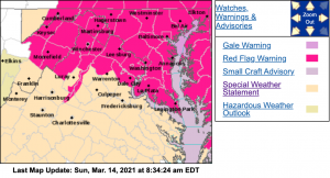
Via NWS : There is an enhanced threat for wildfires today across the Central Virginia Blue Ridge. Click on the image above for the latest from NWS. Sunday - March 14, 2021
Via NWS : There is an enhanced threat for wildfires today across the Central Virginia Blue Ridge. Click on the image above for the latest from NWS. Sunday – March 14, 2021
Special Weather Statement
National Weather Service Baltimore MD/Washington DC
428 AM EDT Sun Mar 14 2021

Garrett-Augusta-Rockingham-Page-Nelson-Albemarle-Greene-Madison-
Rappahannock-Orange-Culpeper-Stafford-Spotsylvania-King George-
Southern Fauquier-Western Highland-Eastern Highland-
Central Virginia Blue Ridge-Western Pendleton-Eastern Pendleton-
Including the cities of Mountain Lake Park, Oakland, Grantsville,
Staunton, Waynesboro, Stuarts Draft, Harrisonburg, Luray,
Shenandoah, Stanley, Lovingston, Charlottesville, Stanardsville,
Madison, Washington, Orange, Gordonsville, Culpeper, Falmouth,
Fredericksburg, Dahlgren, Turnbull, Hightown, Monterey,
Wintergreen, Riverton, Brandywine, Franklin, Oak Flat, Ruddle,
and Sugar Grove
428 AM EDT Sun Mar 14 2021

...Enhanced Threat for Fire Spread through this evening...

Dry fuels, low relative humidity, and gusty westerly winds will
produce favorable conditions for wildfire spread through this
evening across portions of far western Maryland, eastern West
Virginia and central and western Virginia.

Residents are urged to exercise caution handling any potential
ignition source, including machinery, cigarettes, and matches. Be
sure to properly discard all smoking materials. Any dry grasses
and tree litter that ignite will have the potential to spread
quickly.

$$
Special Weather Statement
National Weather Service Blacksburg VA
528 AM EDT Sun Mar 14 2021


Montgomery-Carroll-Floyd-Craig-Alleghany VA-Bath-Roanoke-
Botetourt-Rockbridge-Patrick-Franklin-Bedford-Amherst-Henry-
Pittsylvania-Campbell-Appomattox-Buckingham-Halifax-Charlotte-
Including the cities of Blacksburg, Galax, Floyd, New Castle,
Clifton Forge, Covington, Hot Springs, Roanoke, Salem, Fincastle,
Lexington, Buena Vista, Stuart, Rocky Mount, Bedford, Amherst,
Martinsville, Danville, Lynchburg, Appomattox, South Boston,
and Keysville
528 AM EDT Sun Mar 14 2021

...Elevated Risk for Wildfires Today...

Dry fuels, low relative humidity, and gusty northwest winds from
late morning through the late afternoon are expected to result in
favorable conditions for wildfires to spread.

Residents are urged to exercise caution handling any potential
ignition source...including machinery...cigarettes...and matches.
Be sure to properly discard all smoking materials. Fire from any
dry grasses and tree litter that ignites will have the potential
to spread quickly.

Virginia residents are reminded that open burning is prohibited
before 4 pm each day through April 30th.
URGENT - FIRE WEATHER MESSAGE
National Weather Service Baltimore MD/Washington DC
401 AM EDT Sun Mar 14 2021

District of Columbia-Washington-Frederick MD-Carroll-
Northern Baltimore-Cecil-Southern Baltimore-Prince Georges-
Anne Arundel-Extreme Western Allegany-
Central and Eastern Allegany-Northwest Montgomery-
Central and Southeast Montgomery-Northwest Howard-
Central and Southeast Howard-Northwest Harford-Southeast Harford-
Frederick VA-Clarke-Fairfax-Arlington/Falls Church/Alexandria-
Western Loudoun-Eastern Loudoun-Northern Virginia Blue Ridge-
Hampshire-Morgan-Berkeley-Jefferson-Hardy-Western Grant-
Eastern Grant-Western Mineral-Eastern Mineral-
401 AM EDT Sun Mar 14 2021

...RED FLAG WARNING IN EFFECT FROM 8 AM THIS MORNING TO 10 PM EDT
THIS EVENING FOR GUSTY WINDS AND LOW HUMIDITY FOR PORTIONS OF
NORTHERN VIRGINIA...MUCH OF MARYLAND...EASTERN WEST VIRGINIA...AND
THE DISTRICT OF COLUMBIA...

The National Weather Service in Baltimore MD/Washington has
issued a Red Flag Warning for gusty winds and low humidity, which
is in effect from 8 AM this morning to 10 PM EDT this evening.
The Fire Weather Watch is no longer in effect.

* WINDS...Northwest 15 to 25 mph with gusts up to 35 mph.

* RELATIVE HUMIDITY...15 to 25 percent.

* IMPACTS...Critical fire weather conditions are expected to
  develop today. All outdoor burning is discouraged, as fires
  could rapidly spread and become uncontrollable.

* FUEL MOISTURE...3 to 6 percent for fine fuels.

PRECAUTIONARY/PREPAREDNESS ACTIONS...

A Red Flag Warning means that critical fire weather conditions
are either occurring now, or will shortly. A combination of
strong winds, low relative humidity, and warm temperatures can
contribute to extreme fire behavior. Be careful of heat and
sparks while operating any equipment, and avoid smoking in
wildland areas.

