

Central Virginia Blue Ridge
By Tommy Stafford
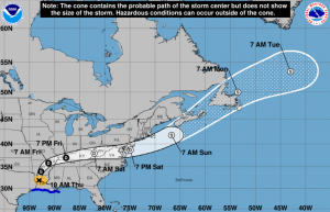
Most of us have been watching early Thursday as Hurricane Laura came ashore in Louisiana. As she made landfall the storm was a very strong category 4 hurricane with winds of 150 MPH. That nearly makes Laura a category 5 storm. Winds of 156 MPH or greater would be CAT 5. Obviously the brunt of the damage from wind and storm surge will be confined to the Louisiana vicinity where Laura is coming ashore. But once the storm continues moving north then eastward toward the Mid-Atlantic by the weekend, we could see fallout from what will then be Tropical Depression Laura.


In the local National Weather Service (Baltimore / DC Office) Thursday morning Forecaster Discussion there is also a reference to Laura having some impact on the weather across the Central Virginia Blue Ridge and the Mid-Atlantic area this weekend.
The remnants of Laura will pass through the Tennessee Valley
Friday night. A few showers may approach the area overnight, but
most of the activity should hold off until Saturday.

Locally, heavy rainfall and isolated instances of flooding are
possible Saturday. Scattered severe thunderstorms (including the
potential for gusty to damaging winds or a few tornadoes) are
possible as well as the remnants of Laura interact with an
approaching cold front and a strengthening upper jet.

Refer to the National Hurricane Center for the latest information
regarding the track of Laura.
I’ll be keeping a watch into the weekend and update as we move along. The good news as of now, Laura is not expected to linger across our area (given current forecasts as of Thursday morning) and should exit quicky to the northeast by the second half of the weekend.
Have a great Thursday!
Tommy`

