")
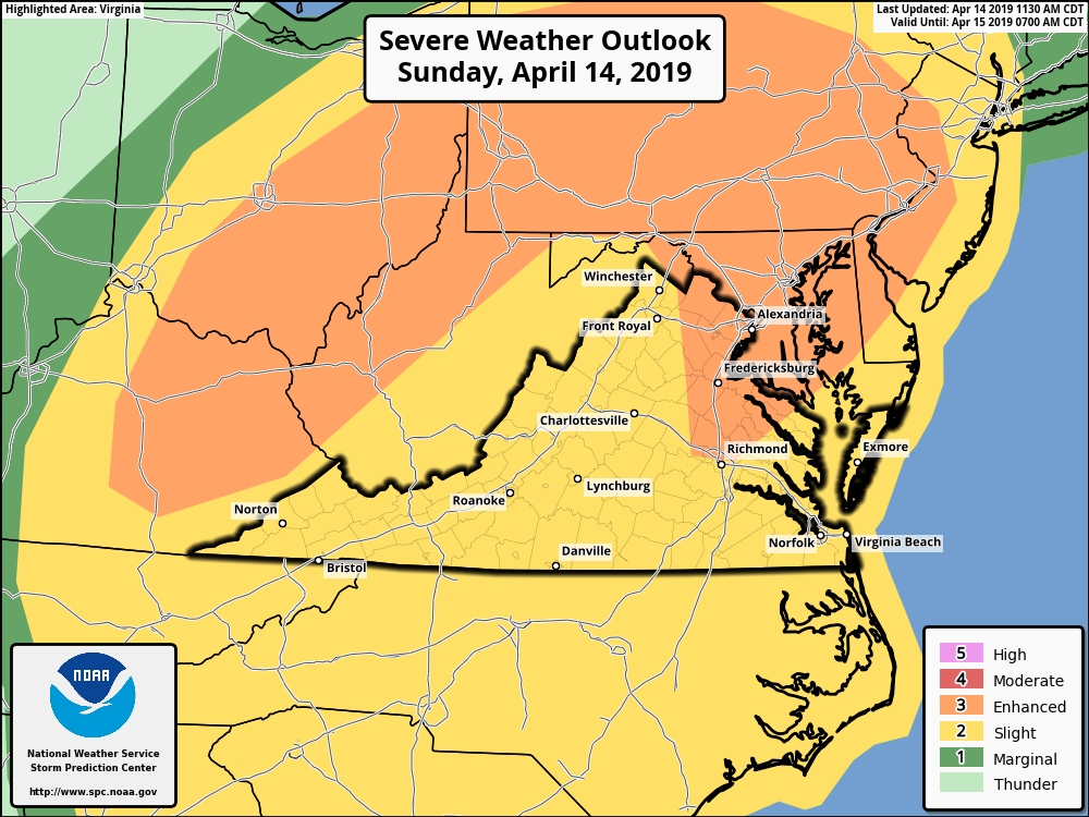 Image from the Storm Prediction Center : As of 8:30 Sunday morning – Nelson and the immediate surrounding are are in the slight risk area (yellow) for severe weather on Sunday. An enhanced risk area (greater probability) is indicated in the orange shaded areas.
Central Virginia Blue Ridge
Nelson County, Virginia
The threat for severe weather has ended and is no longer a factor.
Earlier post:
Updated 2:30 PM – April 14, 2019
As we get more into spring the return of severe weather becomes more likely, particular over the next several weeks until we get into the dead of summer. For several days I’ve been discussing the potential for severe weather to hit this afternoon & evening.
The Storm Prediction Center in Norman, Oklahoma is watching for the potential of severe weather to set up across our general area on this afternoon and into the night.
A deepening area of low pressure will be developing Sunday afternoon that will create the environment for possible severe storms. In our immediate region near Nelson, the most likely threat would be damaging winds and heavy rains, though an isolated tornado can’t be ruled completely out. The absolute best chances for any tornadoes would be more south and west of our area.
 A broader view of the risk area from the Storm Prediction Center.
The local NWS office out of Sterling, Virginia mentions the threat in their Saturday weather discussion.
“The threat for severe weather will increase this afternoon and
tonight. There are two rounds for possible severe thunderstorms.The first round is late this afternoon into early this evening.
Low pressure will pass by to our west through the Ohio Valley
before moving into the eastern Great Lakes during this time.
The cold front associated with the low will remain well to the
west, but a strengthening gradient will cause gusty southerly
winds to develop during the afternoon (around 30-40 mph). These
southerly winds will usher in plenty of moisture. Precipitable waters and
specific humidity are progged to be nearly maxed out relative to
climatology. At the same time, the wind field will be
strengthening at all levels of the atmosphere, causing
significant deep layer shear and low-level helicity to develop
throughout the afternoon. A band of showers and thunderstorms
are likely to race well ahead of the boundary this afternoon,
moving into our western areas this afternoon and toward the
Washington and Baltimore metropolitan areas this evening. This
activity will be associated with shortwave energy, a mid-level
jetmax and divergent flow at the upper-levels of the
atmosphere. The main question will be how much instability
develops, because it will be somewhat limited due to extensive
mid-level cloud cover. That having been said, it will not take
much instability for a few of these thunderstorms to be severe
late this afternoon into early this evening, and that is because
of the strengthening wind field. Confidence with the first round
of potential severe storms is low, but locally damaging wind
gusts, large hail and perhaps an isolated tornado cannot be ruled
out since these cells may be more discrete, causing the
possibility of supercells. The best chance for severe
thunderstorms will be near and west of the Blue Ridge mountains
with the first round, since convection will arriving around peak
heating across these areas and moving into the Metro areas after
sunset. Isolated instances of flooding are possible as well due to
heavy rainfall rates and potential of training convection.The second round of potential severe thunderstorms are expected
later this evening and overnight. A strong cold front is
expected to move through the area during this time. The wind
field is progged to be very strong with 70-80 knots of deep
layer shear most likely tonight. The strong shear combined with
forcing from the front and strong moisture advection should cause
a qlcs type feature to develop near the cold front late this
evening across western areas and that line will likely pass
through much of the area during the overnight hours. The main
threat will be damaging winds with the line, but an isolated
tornado and isolated instances of flooding cannot be ruled out as
well.The cold front will be near the near the I-95 corridor by Monday
morning, but the convection should be well off to our east by
that time. Gusty west to northwest winds will develop behind the
cold front along with upslope rain and snow showers near the
Allegheny Front.“
I’ll keep an eye on all of this and update the maps throughout the day as new ones come out.
Tommy
