
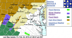
URGENT – WINTER WEATHER MESSAGE
National Weather Service Baltimore MD/Washington DC
257 PM EST Fri Feb 22 2019
Western Highland-Eastern Highland-Central Virginia Blue Ridge-
Western Pendleton-Eastern Pendleton-
257 PM EST Fri Feb 22 2019
…WINTER WEATHER ADVISORY IN EFFECT FROM 3 AM TO NOON EST
SATURDAY…
* WHAT…Freezing rain expected. Total ice accumulations around
one-tenth of an inch expected.
* WHERE…In Virginia, Western Highland and Eastern Highland
Counties, and Central Virginia Blue Ridge. In West Virginia,
Western Pendleton and Eastern Pendleton Counties.
* WHEN…From 3 AM to noon EST Saturday.
* ADDITIONAL DETAILS…Ice may create slippery travel and walking
conditions in some areas.
PRECAUTIONARY/PREPAREDNESS ACTIONS…
A Winter Weather Advisory means that periods of freezing rain
will cause travel difficulties. Expect slippery roads. Slow down
and use caution while driving.
When venturing outside, watch your first few steps taken on
steps, sidewalks, and driveways, which could be icy and slippery,
increasing your risk of a fall and injury.
Zone Forecast Product
National Weather Service Baltimore MD/Washington DC
336 PM EST Fri Feb 22 2019Central Virginia Blue Ridge-
Including the city of Wintergreen
336 PM EST Fri Feb 22 2019…WINTER WEATHER ADVISORY IN EFFECT FROM 3 AM TO NOON EST
SATURDAY…
…FLOOD WATCH IN EFFECT FROM SATURDAY AFTERNOON THROUGH LATE
SATURDAY NIGHT…
…HIGH WIND WATCH IN EFFECT FROM SUNDAY MORNING THROUGH MONDAY
MORNING….REST OF THIS AFTERNOON…Cloudy with a 50 percent chance of
rain. Highs in the lower 40s. Southeast winds around 5 mph.
.TONIGHT…A chance of rain in the evening, then rain or freezing
rain likely after midnight. Ice accumulation around a trace. Lows
in the lower 30s. East winds around 5 mph. Chance of
precipitation 70 percent.
.SATURDAY…Rain or freezing rain in the morning, then rain in
the afternoon. Ice accumulation of up to a tenth of an inch.
Highs in the upper 30s. Southeast winds 5 to 10 mph. Chance of
precipitation near 100 percent.
.SATURDAY NIGHT…Rain. Lows in the upper 30s. South winds 5 to
10 mph, increasing to southwest 15 to 20 mph after midnight.
Chance of rain near 100 percent.
.SUNDAY…Mostly cloudy with showers likely in the morning, then
mostly sunny in the afternoon. Very windy and much warmer with
highs in the lower 60s. Temperature falling into the lower 50s in
the afternoon. Southwest winds 15 to 25 mph with gusts up to
50 mph, increasing to west 25 to 35 mph with gusts up to 60 mph
in the afternoon. Chance of rain 60 percent.
.SUNDAY NIGHT…Mostly clear and windy. Lows in the lower 30s.
.MONDAY…Sunny, breezy with highs in the lower 40s.
.MONDAY NIGHT…Mostly clear. Lows in the upper 20s.
.TUESDAY…Mostly sunny. Highs in the mid 40s.
.TUESDAY NIGHT…Partly cloudy. Lows in the upper 20s.
.WEDNESDAY…Partly sunny. Highs in the mid 40s.
.WEDNESDAY NIGHT…Mostly cloudy. Lows in the upper 20s.
.THURSDAY…Mostly sunny. Highs in the lower 40s.
URGENT – WEATHER MESSAGE
National Weather Service Baltimore MD/Washington DC
139 PM EST Fri Feb 22 2019
Extreme Western Allegany-Western Highland-Eastern Highland-
Northern Virginia Blue Ridge-Central Virginia Blue Ridge-
Western Grant-Eastern Grant-Western Mineral-Western Pendleton-
Eastern Pendleton-
Including the cities of Frostburg, Hightown, Monterey,
Big Meadows, Wintergreen, Bayard, Mount Storm, Petersburg,
Elk Garden, Riverton, Brandywine, Franklin, Oak Flat, Ruddle,
and Sugar Grove
139 PM EST Fri Feb 22 2019
…HIGH WIND WATCH IN EFFECT FROM SUNDAY MORNING THROUGH MONDAY
MORNING…
The National Weather Service in Baltimore MD/Washington has
issued a High Wind Watch, which is in effect from Sunday morning
through Monday morning.
* TIMING…10 AM Sunday morning through 10 AM Monday morning.
* WINDS…Southwest late Sunday morning becoming west to northwest
Sunday afternoon through Monday morning around 25 to 40 mph
with the potential for gusts around 60 mph. The strongest winds
are most likely over the higher elevations above 1500 feet.
* IMPACTS…There is the potential for downed trees, powerlines,
and minor structural damage. Driving high profile vehicles in
these conditions is dangerous.
PRECAUTIONARY/PREPAREDNESS ACTIONS…
A High Wind Watch means there is the potential for a hazardous
high wind event. Sustained winds of at least 40 mph, or gusts of
58 mph or stronger may occur. Continue to monitor the latest
forecasts.
Flood Watch
National Weather Service Baltimore MD/Washington DC
258 PM EST Fri Feb 22 2019
Augusta-Nelson-Western Highland-Eastern Highland-
Central Virginia Blue Ridge-
Including the cities of Staunton, Waynesboro, Stuarts Draft,
Lovingston, Hightown, Monterey, and Wintergreen
258 PM EST Fri Feb 22 2019
…FLOOD WATCH IN EFFECT FROM SATURDAY AFTERNOON THROUGH LATE
SATURDAY NIGHT…
The National Weather Service in Sterling Virginia has issued a
* Flood Watch for Augusta, Highland, Nelson, and the central
Virginia Blue Ridge Mountains.
* From Saturday afternoon through late Saturday night.
* Rain is expected through Saturday night, and the steadiest rain
is expected Saturday afternoon and night. Most likely rainfall
amounts will be around around three quarters of an inch to one
and one-half inches.
* Excess runoff due to saturated soil from recent snow melt and
the rain that is expected may cause creeks and streams to rise
out of their banks as well as the potential of flooding in low
lying urban areas.
PRECAUTIONARY/PREPAREDNESS ACTIONS…
A Flood Watch means there is a potential for flooding based on
current forecasts.
You should monitor later forecasts and be alert for possible
Flood Warnings. Those living in areas prone to flooding should be
prepared to take action should flooding develop.
Flood Watch
National Weather Service Blacksburg VA
250 PM EST Fri Feb 22 2019
…Additional Moderate to Heavy Rainfall Possible Late Tonight
into Saturday Night…
.A slow moving warm front lifts northward from the Southeast U.S.
into the mid-Atlantic through Sunday morning followed quickly by a
cold front. An extended period of rain, moderate to heavy at times
will impact the area late tonight into Saturday night.
Surry-Stokes-Rockingham-Caswell-Wilkes-Yadkin-Roanoke-Botetourt-
Rockbridge-Patrick-Franklin-Bedford-Amherst-Henry-Pittsylvania-
Campbell-Appomattox-Buckingham-Halifax-Charlotte-
Including the cities of Dobson, Danbury, Eden, Yanceyville,
Wilkesboro, Yadkinville, Roanoke, Salem, Fincastle, Lexington,
Buena Vista, Stuart, Rocky Mount, Bedford, Amherst, Martinsville,
Danville, Lynchburg, Appomattox, South Boston, and Keysville
250 PM EST Fri Feb 22 2019
…FLOOD WATCH REMAINS IN EFFECT THROUGH SUNDAY MORNING…
The Flood Watch continues for
* Portions of North Carolina and Virginia, including the
following areas, in North Carolina, Caswell, Rockingham,
Stokes, Surry, Wilkes, and Yadkin. In Virginia, Amherst,
Appomattox, Bedford, Botetourt, Buckingham, Campbell,
Charlotte, Franklin, Halifax, Henry, Patrick, Pittsylvania,
Roanoke, and Rockbridge.
* Through Sunday morning
* Periods of moderate to at times heavy rain. Rainfall totals of 1
to 2 inches are expected through Sunday, with locally higher
amounts possible.
* Flooding of low-lying, poor drainage, and normally flood prone
areas. Small creeks and streams will be subject to flooding as
well as larger mainstem rivers.
* Those living along creeks, streams and rivers should be alert
to possible flooding.
PRECAUTIONARY/PREPAREDNESS ACTIONS…
A Flood Watch means there is a potential for flooding based on
current forecasts.
You should monitor later forecasts and be alert for possible
Flood Warnings. Those living in areas prone to flooding should be
prepared to take action should flooding develop.
