
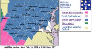
WINTER STORM WARNING IN EFFECT FROM 6 PM TUESDAY TO MIDNIGHT EST WEDNESDAY NIGHT
URGENT – WINTER WEATHER MESSAGE
National Weather Service Blacksburg VA
333 PM EST Mon Feb 18 2019
…Expect wintry weather to impact the area late Tuesday
afternoon into late Wednesday…
.A strong area of high pressure will shifts east into the
Northeast United States, this will result in cold air wedging
down the Appalachians. As a winter storm lifts northeast across
our region, precipitation will spread north over this shallow
dome of cold air, producing a wintry mixture of snow, sleet and
freezing rain.
Alleghany VA-Bath-Botetourt-Rockbridge-Bedford-Amherst-Campbell-
Appomattox-Buckingham-Eastern Greenbrier-Western Greenbrier-
Including the cities of Clifton Forge, Covington, Hot Springs,
Fincastle, Lexington, Buena Vista, Amherst, Lynchburg,
Appomattox, Lewisburg, White Sulphur Springs, Quinwood, Duo,
and Rainelle
333 PM EST Mon Feb 18 2019
…WINTER STORM WARNING IN EFFECT FROM 6 PM TUESDAY TO MIDNIGHT
EST WEDNESDAY NIGHT…
* WHAT…Heavy mixed precipitation expected. Total snow and sleet
accumulations of 1 to 3 inches…with locally higher amounts across
the Alleghanys and Blue Ridge. Ice accumulations of one tenth
to three tenths of an inch expected.
* WHERE…Portions of central, south central and west central
Virginia and southeast West Virginia.
* WHEN…From 6 PM Tuesday to midnight EST Wednesday night.
* ADDITIONAL DETAILS…Power outages and tree damage are likely
due to the ice. Travel could be nearly impossible. The
hazardous conditions could impact the morning or evening
commute.
PRECAUTIONARY/PREPAREDNESS ACTIONS…
A Winter Storm Warning means significant amounts of snow, sleet
and ice will make travel very hazardous or impossible.
The latest road conditions for the state you are calling from can
be obtained by calling 5 1 1.
URGENT – WINTER WEATHER MESSAGE
National Weather Service Baltimore MD/Washington DC
126 PM EST Mon Feb 18 2019
District of Columbia-Washington-Frederick MD-Carroll-
Northern Baltimore-Southern Baltimore-Prince Georges-Anne Arundel-
Extreme Western Allegany-Central and Eastern Allegany-
Northwest Montgomery-Central and Southeast Montgomery-
Northwest Howard-Central and Southeast Howard-Northwest Harford-
Southeast Harford-Augusta-Rockingham-Shenandoah-Frederick VA-Page-
Warren-Clarke-Nelson-Albemarle-Greene-Madison-Rappahannock-Orange-
Culpeper-Prince William/Manassas/Manassas Park-Fairfax-
Arlington/Falls Church/Alexandria-Stafford-Spotsylvania-
Northern Fauquier-Southern Fauquier-Western Highland-
Eastern Highland-Western Loudoun-Eastern Loudoun-
Northern Virginia Blue Ridge-Central Virginia Blue Ridge-
Hampshire-Morgan-Berkeley-Jefferson-Hardy-Western Grant-
Eastern Grant-Western Mineral-Eastern Mineral-Western Pendleton-
Eastern Pendleton-
126 PM EST Mon Feb 18 2019
…WINTER STORM WATCH REMAINS IN EFFECT FROM TUESDAY EVENING
THROUGH WEDNESDAY EVENING…
* WHAT…Heavy snow, mixing with and eventually changing to
sleet and then freezing rain. Snow accumulations of 5 or more
inches and ice accumulations of a quarter-inch or greater are
possible.
* WHERE…The District of Columbia, Maryland east of the
Alleghany Front and west of the Chesapeake Bay, central and
northern Virginia, and the eastern West Virginia panhandle.
* WHEN…From Tuesday evening through Wednesday evening.
* ADDITIONAL DETAILS…Travel could be very difficult. The
hazardous conditions could impact the morning and evening
commute.
PRECAUTIONARY/PREPAREDNESS ACTIONS…
A Winter Storm Watch means there is potential for significant
snow, sleet or ice accumulations that may impact travel. Continue
to monitor the latest forecasts.
