
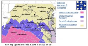
 As of 7:15 AM Sunday most of the Blue Ridge area in Central Virginia from Augusta and Albemarle south is under a Winter Storm Warning for all of Sunday into Sunday night. Click on the image above for the absolute latest updates from NWS.
Central Virginia Blue Ridge
WINTER STORM WARNING
URGENT – WINTER WEATHER MESSAGE
National Weather Service Baltimore MD/Washington DC
322 AM EST Sun Dec 9 2018
VAZ037-508-091630-
/O.EXT.KLWX.WS.W.0011.181209T1200Z-181210T0500Z/
Albemarle-Central Virginia Blue Ridge-
322 AM EST Sun Dec 9 2018
…WINTER STORM WARNING NOW IN EFFECT FROM 7 AM THIS MORNING TO
MIDNIGHT EST TONIGHT…
* WHAT…Heavy snow expected. Total snow accumulations of 4 to 7
inches expected, with highest amounts in the southern portions
of the county.
* WHERE…Central Virginia Blue Ridge, and Albemarle County.
* WHEN…From 7 AM this morning to midnight EST tonight.
* ADDITIONAL DETAILS…Plan on snow covered and slippery roads.
Travel will be dangerous. Temperatures will remain well below
freezing Sunday night, so any untreated surfaces will remain
snow covered and slippery.
PRECAUTIONARY/PREPAREDNESS ACTIONS…
A Winter Storm Warning for snow means severe winter weather
conditions will make travel very hazardous or impossible. If you
must travel, keep an extra flashlight, food and water in your
vehicle in case of an emergency.
The latest road conditions for the state you are calling from can
be obtained by calling 5 1 1.
&&
$$
URGENT – WINTER WEATHER MESSAGE
National Weather Service Baltimore MD/Washington DC
322 AM EST Sun Dec 9 2018
VAZ025-091630-
/O.UPG.KLWX.WW.Y.0027.181209T1100Z-181210T0500Z/
/O.EXB.KLWX.WS.W.0011.181209T1200Z-181210T0500Z/
Augusta-
322 AM EST Sun Dec 9 2018
…WINTER STORM WARNING IN EFFECT FROM 7 AM THIS MORNING TO
MIDNIGHT EST TONIGHT…
* WHAT…Heavy snow expected. Total snow accumulations of 3 to 7
inches expected, with highest amounts in the southern portions
of the county.
* WHERE…Augusta County.
* WHEN…From 7 AM this morning to midnight EST tonight.
* ADDITIONAL DETAILS…Plan on snow covered and slippery roads.
Travel will be dangerous. Temperatures will remain well below
freezing Sunday night, so any untreated surfaces will remain
snow covered and slippery.
PRECAUTIONARY/PREPAREDNESS ACTIONS…
A Winter Storm Warning for snow means severe winter weather
conditions will make travel very hazardous or impossible. If you
must travel, keep an extra flashlight, food and water in your
vehicle in case of an emergency.
The latest road conditions for the state you are calling from can
be obtained by calling 5 1 1.
&&
$$
URGENT – WINTER WEATHER MESSAGE
National Weather Service Baltimore MD/Washington DC
322 AM EST Sun Dec 9 2018
VAZ036-091630-
/O.EXT.KLWX.WS.W.0011.181209T1000Z-181210T0500Z/
Nelson-
322 AM EST Sun Dec 9 2018
…WINTER STORM WARNING NOW IN EFFECT UNTIL MIDNIGHT EST
TONIGHT…
* WHAT…Heavy snow expected. Total snow accumulations of 6 to 9
inches expected, with highest amounts in the southern portions
of the county.
* WHERE…Nelson County.
* WHEN…Until midnight EST tonight.
* ADDITIONAL DETAILS…Plan on snow covered and slippery roads.
Travel will be dangerous. Temperatures will remain well below
freezing Sunday night, so any untreated surfaces will remain
snow covered and slippery.
PRECAUTIONARY/PREPAREDNESS ACTIONS…
A Winter Storm Warning for snow means severe winter weather
conditions will make travel very hazardous or impossible. If you
must travel, keep an extra flashlight, food and water in your
vehicle in case of an emergency.
The latest road conditions for the state you are calling from can
be obtained by calling 5 1 1.
&&
$$
URGENT – WINTER WEATHER MESSAGE
National Weather Service Blacksburg VA
414 AM EST Sun Dec 9 2018
…WINTER STORM WILL BRING SNOW HEAVY AT TIMES SUNDAY…
.Low pressure tracks from the Gulf Coast this morning to off the
Georgia coast this afternoon, then lifts northeast off the North
Carolina coast this evening. Cold high pressure covers the Ohio
the Mid-Atlantic region during this time. A prolonged period of
moderate to heavy snow is expected across the region, with the
heaviest across southern Virginia into western North Carolina.
VAZ011-018-023-035-047-WVZ042-092100-
/O.CON.KRNK.WS.W.0007.181209T1200Z-181210T1600Z/
Giles-Craig-Botetourt-Amherst-Buckingham-Mercer-
Including the cities of Pearisburg, New Castle, Fincastle,
Amherst, and Bluefield
414 AM EST Sun Dec 9 2018
…WINTER STORM WARNING REMAINS IN EFFECT FROM 7 AM THIS MORNING
TO 11 AM EST MONDAY…
* WHAT…Heavy snow expected. Total snow accumulations of 5 to 10
inches expected.
* WHERE…Portions of central, southwest and west central
Virginia and southeast West Virginia.
* WHEN…From 7 AM this morning to 11 AM EST Monday.
* ADDITIONAL DETAILS…Travel could be very difficult to
impossible. Plan on snow covered roads. Blowing and drifting
snow is expected at higher elevations.
PRECAUTIONARY/PREPAREDNESS ACTIONS…
A Winter Storm Warning for snow means severe winter weather
conditions will make travel very hazardous or impossible. If you
must travel, keep an extra flashlight, food and water in your
vehicle in case of an emergency.
The public is encouraged to report snowfall amounts or damage to
the National Weather Service via email at rnk.skywarn@noaa.gov…
through Facebook or Twitter…or by calling 1…8 6 6…2 1 5…
4 3 2 4. Pictures are greatly appreciated.
The latest road conditions for the state you are calling from can
be obtained by calling 5 1 1.
&&
$$
URGENT – WINTER WEATHER MESSAGE
National Weather Service Blacksburg VA
414 AM EST Sun Dec 9 2018
…WINTER STORM WILL BRING SNOW HEAVY AT TIMES SUNDAY…
.Low pressure tracks from the Gulf Coast this morning to off the
Georgia coast this afternoon, then lifts northeast off the North
Carolina coast this evening. Cold high pressure covers the Ohio
the Mid-Atlantic region during this time. A prolonged period of
moderate to heavy snow is expected across the region, with the
heaviest across southern Virginia into western North Carolina.
VAZ019-024-WVZ043-044-092100-
/O.UPG.KRNK.WW.Y.0023.181209T1200Z-181210T1600Z/
/O.EXA.KRNK.WS.W.0007.181209T1200Z-181210T1600Z/
Alleghany VA-Rockbridge-Summers-Monroe-
Including the cities of Clifton Forge, Covington, Lexington,
Buena Vista, Hinton, Hix, and Union
414 AM EST Sun Dec 9 2018
…WINTER STORM WARNING IN EFFECT FROM 7 AM THIS MORNING TO 11 AM
EST MONDAY…
* WHAT…Heavy snow expected. Total snow accumulations of 4 to 6
inches expected.
* WHERE…In Virginia, Alleghany VA and Rockbridge Counties. In
West Virginia, Summers and Monroe Counties.
* WHEN…From 7 AM this morning to 11 AM EST Monday.
* ADDITIONAL DETAILS…Travel will be very difficult.
PRECAUTIONARY/PREPAREDNESS ACTIONS…
A Winter Storm Warning for snow means severe winter weather
conditions will make travel very hazardous or impossible. If you
must travel, keep an extra flashlight, food and water in your
vehicle in case of an emergency.
The latest road conditions for the state you are calling from can
be obtained by calling 5 1 1.
&&
$$
URGENT – WINTER WEATHER MESSAGE
National Weather Service Blacksburg VA
414 AM EST Sun Dec 9 2018
…WINTER STORM WILL BRING SNOW HEAVY AT TIMES SUNDAY…
.Low pressure tracks from the Gulf Coast this morning to off the
Georgia coast this afternoon, then lifts northeast off the North
Carolina coast this evening. Cold high pressure covers the Ohio
the Mid-Atlantic region during this time. A prolonged period of
moderate to heavy snow is expected across the region, with the
heaviest across southern Virginia into western North Carolina.
VAZ034-045-046-059-092100-
/O.CON.KRNK.WS.W.0007.000000T0000Z-181210T1600Z/
Bedford-Campbell-Appomattox-Charlotte-
Including the cities of Lynchburg, Appomattox, and Keysville
414 AM EST Sun Dec 9 2018
…WINTER STORM WARNING REMAINS IN EFFECT UNTIL 11 AM EST
MONDAY…
* WHAT…Heavy snow expected. Total snow accumulations of 8 to 16
inches expected.
* WHERE…Bedford, Appomattox, Charlotte and Campbell Counties.
* WHEN…Until 11 AM EST Monday.
* ADDITIONAL DETAILS…Travel could be very difficult to
impossible. Plan on snow covered roads.
PRECAUTIONARY/PREPAREDNESS ACTIONS…
A Winter Storm Warning for snow means severe winter weather
conditions will make travel very hazardous or impossible. If you
must travel, keep an extra flashlight, food and water in your
vehicle in case of an emergency.
The public is encouraged to report snowfall amounts or damage to
the National Weather Service via email at rnk.skywarn@noaa.gov…
through Facebook or Twitter…or by calling 1…8 6 6…2 1 5…
4 3 2 4. Pictures are greatly appreciated.
The latest road conditions for the state you are calling from can
be obtained by calling 5 1 1.
