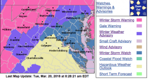
URGENT – WINTER WEATHER MESSAGE
National Weather Service Baltimore MD/Washington DC
429 AM EDT Tue Mar 20 2018
Frederick MD-Carroll-Northern Baltimore-Northwest Montgomery-
Northwest Howard-Northwest Harford-Southeast Harford-Augusta-
Rockingham-Shenandoah-Page-Warren-Clarke-Western Loudoun-
Northern Virginia Blue Ridge-Central Virginia Blue Ridge-
Jefferson-
429 AM EDT Tue Mar 20 2018
…WINTER WEATHER ADVISORY REMAINS IN EFFECT UNTIL 6 PM EDT THIS
EVENING…
…WINTER STORM WATCH REMAINS IN EFFECT FROM LATE TONIGHT THROUGH
WEDNESDAY EVENING…
* WHAT…A mix of snow, sleet and freezing rain is expected today.
Snow and sleet accumulations of a coating to 3 inches, and up to
one tenth inch of ice are expected today. Heavy wet snow is
possible Tuesday night into Wednesday, with total snow
accumulation of 5 inches or more possible.
* WHERE…Portions the Shenandoah Valley, Blue Ridge Mountains,
and northern Maryland.
* WHEN…For the Winter Weather Advisory, until 6 PM EDT this
evening. For the Winter Storm Watch, from late tonight through
Wednesday evening.
* ADDITIONAL DETAILS…The snow and ice will result in difficult
travel conditions today. Be prepared for reduced visibilities at
times. Difficult travel conditions and significant reductions
in visibility are possible late tonight through Wednesday.
PRECAUTIONARY/PREPAREDNESS ACTIONS…
A Winter Weather Advisory means that periods of snow, sleet or
freezing rain will cause travel difficulties. Be prepared for
slippery roads and limited visibilities, and use caution while
driving. The latest road conditions for the state you are calling
from can be obtained by calling 5 1 1.
URGENT – WINTER WEATHER MESSAGE
National Weather Service Blacksburg VA
506 AM EDT Tue Mar 20 2018
…Another snow storm on the way for the Central Appalachians and
Adjacent Areas…
.A complex winter storm system will develop across Ohio Valley and
shift slowly southeastward through the eastern Tennessee Valley,
central and southern Appalachians, and then toward the mid-
Atlantic coast through the first half of this week. This will
bring a prolonged period of light to moderate precipitation to the
area beginning today in the form of rain, then change mostly to
snow overnight and into Wednesday as colder air spreads southward
from the northeast U.S. Precipitation may mix with rain in the
valleys again during the day on Wednesday. The greatest
accumulations of wet snow are expected along and west of the Blue
Ridge, and especially at the higher elevations, with lesser
amounts over the piedmont and foothills. While average snowfall
amounts are expected to be in the 3 to 6 inch range for areas
along and west of the Blue Ridge, with lesser amounts across the
Piedmont, snowfall amounts up to a foot are possible along the
I-64 corridor and the Greenbrier Valley of eastern West Virginia.
Patrick-Franklin-Bedford-Amherst-Campbell-Appomattox-Buckingham-
Including the cities of Stuart, Rocky Mount, Bedford, Amherst,
Lynchburg, and Appomattox
506 AM EDT Tue Mar 20 2018
…WINTER WEATHER ADVISORY IN EFFECT FROM MIDNIGHT TONIGHT TO
8 AM EDT THURSDAY…
* WHAT…Snow expected. Total snow accumulations of 1 to 3
inches are expected.
* WHERE…Portions of central, south central, southwest and west
central Virginia, mainly east of the Blue Ridge and west of a
line from Buckingham, to Appomattox, to Rocky Mount, to Stuart.
* WHEN…From midnight tonight to 8 AM EDT Thursday.
* ADDITIONAL DETAILS…Plan on difficult travel conditions
throughout the day Wednesday, along with reduced visibility in
periods of heavier precipitation.
PRECAUTIONARY/PREPAREDNESS ACTIONS…
A Winter Weather Advisory for snow means periods of snow will
cause primarily travel difficulties. Be prepared for snow covered
roads and limited visibilities, and use caution while driving.
The latest road conditions for the state you are calling from can
be obtained by calling 5 1 1.

