REFRESH Nelson County Life Magazine HERE

Forecast By Tommy Stafford – Nelson County Life Magazine
LISTEN TO THE WEATHER BY PRESSING THE BUTTON.
Photography By Paul Purpura
Nelson County Life Magazine ©2008
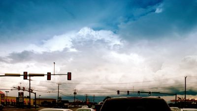
Storm Clouds on The Horizon
Augusta County, Virginia
Today’s weather and is brought to you exclusively by:

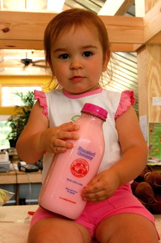
Olivia Harris of a.m. Fog Shows Off One of The Homestead Creamery Varieties
Afton, Virginia
Most of you know by now that Yvette and I are expecting a child in the fall of this year. Yea, she’s been drinking the milk lots to keep up the calcium! She’s always liked Homestead Creamery milk. You know, it comes in those classic glass bottles, not far off of the kind the milkman used to deliver in simpler times. Most of the stores around here carried it, then one day she walked in and no more! Gone.
Folks this is one popular brand of milk and it’s the best around. No artificial hormones, and about as close to the cow as it comes! Yea, move over happy steer, we’ve got the happy cow now! As soon as Ken and Yvonne Harris up at a.m. Fog heard about this they jumped all over it! And, yep! They have the whole line of Homestead Creamery milk products in the familiar glass bottles, right there in their market on the Nelson-Albemarle County line on Route 151.
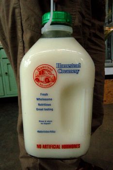
Nothing’s quite as good as a cold glass of milk from one of those chilled bottles!
And now you can get Homestead Creamery milk just up the road at a.m. Fog. along with all of your vegetables, plants and nursery needs to boot!
You can always visit them on the web at www.amfog.net or call ’em at 540-456-7100
Rainfall totals as of 11:59 PM EDT Wednesday night:
–WEDNESDAY’S High / Low at NCL-Nelson County Life Magazine in the Rockfish Valley : 88°/67° – RAIN : 0.18″ – YTD: 16.73″
–WEDNESDAY’S High / Low at NCL-TWNF on Devil’s Knob @ Wintergreen Mountain : 72°/62° – RAIN 0.12″ – YTD: 24.20″
–WEDNESDAY’S High / Low at NCL-Hatcreek Farm on Horseshoe Mountain @ Roseland, VA : 87°/64°– RAIN : 0.10″ – YTD: 24.41″
–WEDNESDAY’S High / Low at NCL-Tiger Fuel @ Lovingston, VA : 86°/68° – RAIN : 0.02″ – YTD: 21.29″
–WEDNESDAY’S High / Low at NCL-Delfosse Winery & Vineyard @ Faber, VA : 87°/66° – RAIN : 0.00″ – YTD: 16.91″
Thanks to our Paul Purpura for today’s weather shot at the top of the post. Paul was over in Augusta county yesterday in Waynesboro when the storms were approaching and he shot this one at the intersection of Lew Dewitt and Rt 340. Those are some pretty ominous looking clouds Paul!
One quick thing before I get to the forecast. Yesterday Keith Dix, co-owner of Basic Necessities in Nellysford was talking to me about rainfall percentages. At first he though I had predicted a 90% chance of storms on Wednesday. If you read my weathercast on a regular basis you know I almost never use percentages when forecasting. That’s what I was explaining to Keith, it’s so unreliable and I see the guys at the NWS get it wrong so many times, like yesterday, I just don’t like to use them. Again, they rely too heavily on the computer models to tell them what’s going to happen and don’t look at what trends are for the particular area. Now I will say in their defense, that the guys at the NWS in Sterling / D.C. area have tons of counties to forecast for, so I understand why they use the most expedient route to get a forecast out. I tend to use a narrative description to forecast the probability vs percentages. But Keith had valid reason to question a 90% prediction of storms yesterday, it never happened, not even close.
Most of the day Wednesday was more or less sunny. We did see some lights showers early in the day, with rain and thunderstorms in the afternoon. Most locations never got more than a fifth of an inch, though a severe thunderstorm watch was issued in the afternoon hours, but was canceled early because nothing really ever developed in our area.
We may have a stray shower early in the day Thursday then look for mostly sunny skies, milder temperatures, and a northerly wind keeping things very nice! Friday looks mostly sunny as well with partly sunny conditions over the weekend with chances for scattered thunderstorms once again.
#97 continues to peak general interest for folks along the eastern seaboard. We’ll see what he does over the next several days, if anything.
![]()
Invest #97
Dolly is now back down to a tropical storm after coming ashore in Texas as a hurricane yesterday Brownsville. As she moves over land, she’ll continue to lose more steam. You can see the latest on what’s happening with her in the images below.
![]()
Dolly Radar Image
![]()
Dolly Computer Projections
![]()
Eastern U.S. Regional Current Surface Map via wunderground

Looking 12-24 Hours Ahead
Your Nelson County Life custom area forecast including: Waynesboro, Nellysford, Tyro, and Naked Mountain.
THURSDAY: Lingering morning showers then mostly sunny and milder by afternoon.
* Highs Valley: 85-88°
*On the mountains: 71-74°
*Winds: NW 5-10 MPH
*OVERNIGHT:Mostly clear and cool. Lows valley: 56-59° : Mountains: 55-58° : Winds: NW 5-10 MPH
FRIDAY: Mostly sunny & warm.
* Highs Valley: 88-91°
*On the mountains: 73-76°
*Winds: SW 5-10 MPH
*OVERNIGHT: Becoming mostly cloudy. Lows valley: 64-67° : Mountains: 60-63° : Winds: S 5-10 MPH
EXTENDED OUTLOOK
SAT: P/S PM T-Storm 88/68
SUN: P/S PM T-Storm 88/67
MON: P/S 84/66
TUE: M/C 83/64
WED: M/C 85/64
All mountain temperatures in the extended period roughly 10-15 degrees cooler than those listed in the valley.
Have a great Thursday!
