REFRESH Nelson County Life Magazine HERE for the latest updates:
Weathercast by Tommy Stafford, Nelson County Life Magazine
NEW! AUDIO VERSION OF TODAY’S FORECAST
Photography by Diana Garland
Nelson County Life Magazine – Copyright 2007
Bug on the Window
Lovingston, Virginia

This guy above must know hot weather is back in the picture. Our NCL photographer, Diana Garland, got this shot of the cute little fellow cooling himself on the glass!
Did you feel how nice it was Monday night and Tuesday morning? We ate supper on the mountain last night with a friends of ours up on Devil’s Knob at The Levels, it was actually chilly by the time we left there. Overnight lows here in the valley even fell to the low 50’s. On the mountain it was warmer with a low of 63. Many times we have that when an inversion sets up.
We’ll have a short burst of a very hot weather over the next 48 hours before we have some almost Fallish temperatures this weekend. We also have a slight chance of severe weather on Thursday afternoon as a frontal boundary makes its way through the area. You can see the areas outlined below, along the references from the NWS:
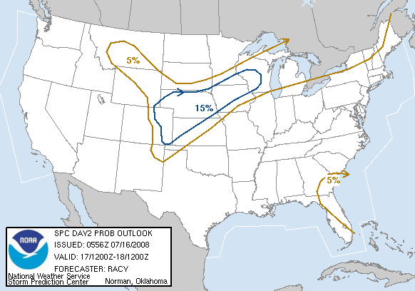
A HEAT INDEX NEAR 100 DEGREES IS EXPECTED THURSDAY AFTERNOON AS HEAT
AND HUMIDITY INCREASES ACROSS THE MID ATLANTIC.A FEW SEVERE THUNDERSTORMS WILL BE POSSIBLE THURSDAY EVENING AND
THURSDAY NIGHT AS A COLD FRONT APPROACHES THE REGION FROM THE OHIO
VALLEY.
There is a slight risk for a tornado or two on Thursday afternoon, but I think the better chances of widespread severe weather are slightly north of Nelson County. And what about old tropical depression # 4, now named Tropical Storm Dean. It’s still holding together and by Sunday peaks my interest. By then we’ll have to start watching him to see what’s really going to happen. Here’s the latest tracking map:

Here are the numbers as of 11:59 PM EDT Monday night
*NCL-Nelson County Life Magazine : Greenfield / Afton
Tues High: 89.4 degrees @ 4:35 PM
Morn Low: 53.2 degrees @ 6:36 AM
0.00″ of rain
*NCL-Wintergreen Nature Foundation : Devil’s Knob
Tues High: 77.9 degrees @ 1:43 PM
Morn Low: 63.0 degrees @ 2:10 AM
0.00″ of rain
*NCL-Wintergreen Winery @ the foot of Wintergreen Mountain in Beech Grove
Tues High: N/A degrees @ 0:00 PM
Morn Low: N/A degrees @ 0:00 AM {STATION OFFLINE AS OF TUES MORNING}
0.00″ of rain
*NCL-Delfosse Vineyard & Winery near Hickory Creek : Faber
Tues High: 89.4 degrees @ 3:45 PM
Morn Low: N/A degrees @ 0:00 AM
0.00″ of rainNCL-Tiger Fuel – Lovingston
Tues High: 89.1 degrees @ 3:31 PM
Morn Low: 55.9 degrees @ 6:22 AM
0.00″ of rainNCL-Mini Tara Vineyards : Arrington
Tues High: 88.7 degrees @ 4:37 PM
Morn Low: N/A degrees @ 0:00 AM
0.00″ of rainCurrent-Sat Surface Map

On the National Forecast Map, a cold front is approaching from our north. It will provide chances for thunderstorms in the forecast by Thursday.
Today’s Forecast Map

Local forecast
*Wednesday Mostly sunny and warmer.
*High temps in Lovingston, Batesville & Tyro 94 degrees.
*On the mountains above 2000 feet along the BRP, Wintergreen, Three Ridges, Devil’s Knob, and Love, Sunny & nice!
Highs top out around 80 degrees.
Winds SW 4-8 MPH
*Wednesday night Mostly clear.
*Lows valley around 62 degrees.
*On the mountains overnight low of 65.
*Winds SW 2-4 MPH becoming northerly after midnight.
Thursday Mostly sunny early, then partly cloudy, hot. Thunderstorms late in the day into the evening.
*Highs valley near 100
*On the mountains around 87
Thursday night muggy with lows generally around 70 degrees.
By the weekend look for a big cool down with a highs on Sunday in the mid to upper 70’s in the valley and upper 60’s on the mountains. Overnight lows in the mid to lower 50’s.
When severe weather or news breaks out, come here. We’ll have all of the latest watches, warnings, and coverage affecting Nelson County, Wintergreen, and nearby counties.
Have a great Wednesday!
Know your Nelson
-T-
