REFRESH Nelson County Life Magazine HERE for the latest updates:
Screen Grab from Wednesday afternoon’s NCL-Weathernet
Nelson County Life Magazine : Copyright 2007
Afton / Greenfield, Virginia
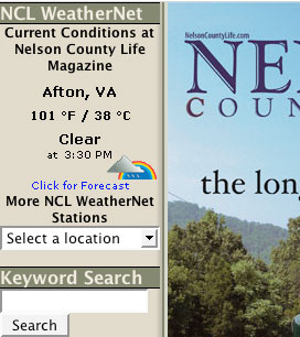
There it is above! Yep 101 degrees Wednesday afternoon high here at Nelson County Life Magazine in Greenfield. Yvette noticed 100 degrees first, then 101 while I was away on the mountain at The Edge having lunch with our NCL photographer, Paul Purpura. It was even hot up there, around 86 at the time! We tied the high temperature with NCL-Tiger Fuel in Lovingston, they hit 101, and NCL-Delfosse Winery almost made it there at 100 ! Overnight lows never dropped out of the 70’s.
Today will still be a hot one, and we may briefly touch 100 again in some locations across Nelson. We have a slightly better chance for thunderstorms this afternoon as a frontal boundary drapes across NOVA. An isolated severe thunderstorm is possible with all of the heat and humidity here to feed the storms that do develop. We don’t get any real relief until this weekend.
Here’s the HOT, HOT, HOT, numbers as of 11:59 PM EDT Wednesday night
*NCL-Nelson County Life Magazine : Greenfield / Afton
Wed High: 101.8 degrees @ 3:47 PM
Heat Index of 113
0.00″ of rain
*NCL-Wintergreen Nature Foundation : Devil’s Knob
Wed High: 86.9 degrees @ 2:13 PM
0.00″ of rain>
*NCL-Delfosse Vineyard & Winery near Hickory Creek : Faber
Wed High:100.6 degrees @ 5:02 PM
0.00″ of rain>>
*NCL-Tiger Fuel – Lovingston
Wed High:101.8 degrees @ 4:33 PM
0.00″ of rain>>
0.00″ of rain
The current surface map continues to show high pressure dominating our weather. This will keep Thursday hot & humid again. A frontal boundary drapes across NOVA increasing our chances for afternoon thunderstorms. A severe storm is possible late in the day.
Current-Sat Surface Map

On the National Forecast Map, the humid air mass stays in place Thursday but a secondary front on Friday and Friday night will finally break the spell! Scattered thunderstorms Friday evening will be followed by cooler drier air overnight into the weekend.
Today’s Forecast Map

Local forecast
*Thursday Partly cloudy, hot & humid once again with temps nearing 100. Scattered afternoon thunderstorms across 20% of the area.
*High temps in Greenfield, Howardsville & Greenwood 96 to 100 degrees.
*On the mountains above 2000 feet along the BRP, Wintergreen, Three Ridges, Devil’s Knob, and Love, Early morning fog, then partly sunny. Hot & muggy with widely scattered afternoon t-storms.
Highs top out around 84 to 87 degrees.
Winds NE in the morning shifting SW in the afternoon 4-6 MPH
*Thursday night Partly cloudy & muggy, isolated t-storms ending.
*Lows valley around 71 degrees.
*On the mountains overnight low of 70.
*Winds Light NW overnight.
*Friday Partly sunny, continued hot scattered PM storms.
*High temp around 95 degrees.
*On the mountains Mostly sunny & hot with an afternoon high near 80. A scattered storm possible.
Winds becoming WNW 3-5 MPH
By the weekend look for temps cooling into the upper 80’s and less humid Overnight lows, low & mid 60’s. Slightly cooler mountains. Overnight lows at Wintergreen Mountain cooling to upper 50’s by Sunday night.
Remember when severe weather or news breaks out, come here. We’ll have all of the latest watches, warnings, and coverage affecting Nelson County, Wintergreen, and nearby counties.
Have a great Thursday!
Know your Nelson
-T-

At D’Ambola’s the temp is exactly 101.2 at 1:25.I envy your 98
Ahhhhh, you are so right Phil. We are basically getting out the winter jackets here now since it’s so much cooler!
-T-