
Central Virginia Blue Ridge
A Winter Weather Advisory has been issued for the Blue Ridge Parkway and Skyline Drive most of the day Monday. 2-5 inches of snow is possible especially in the highest of elevations on grassy, unpaved areas. Click here for more info on that bulletin.
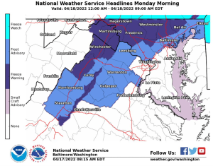
A variety of winter weather bulletins goes into effect late Sunday night into Monday morning across the Central Virginia Blue Ridge. Freeze Warnings are primarily confined to the higher elevations along the Blue Ridge Parkway and Skyline Drive. Frost advisories in some other areas.
The potential for a couple of inches of snow is in play as well in places like Wintergreen and Montebello in the higher elevations along the BRP.
Zone Forecast Product
National Weather Service Baltimore MD/Washington DC
938 AM EDT Sun Apr 17 2022


VAZ508-171700-
Central Virginia Blue Ridge-
Including the city of Wintergreen
938 AM EDT Sun Apr 17 2022

...FREEZE WARNING IN EFFECT FROM MIDNIGHT TONIGHT TO 9 AM EDT
MONDAY...
...WINTER WEATHER ADVISORY IN EFFECT FROM 5 AM TO 8 PM EDT
MONDAY...

.REST OF SUNDAY...Mostly sunny. Highs in the upper 50s. North
winds 5 to 10 mph.
.SUNDAY NIGHT...Mostly cloudy. Snow likely with a chance of rain after
midnight. Widespread frost after midnight. Little or no snow
accumulation. Lows in the lower 30s. East winds 10 to 15 mph with
gusts up to 25 mph. Chance of precipitation 70 percent.
.MONDAY...Snow and rain. Sleet, mainly in the morning. Snow and
sleet accumulation around an inch. Cooler with highs in the upper
30s. East winds 10 to 15 mph with gusts up to 25 mph. Chance of
precipitation near 100 percent.
Tommy
URGENT - WEATHER MESSAGE
National Weather Service Baltimore MD/Washington DC
813 AM EDT Sun Apr 17 2022

Washington-Frederick MD-Carroll-Northern Baltimore-
Northwest Howard-Northwest Harford-Shenandoah-Frederick VA-Clarke-
Northern Virginia Blue Ridge-Central Virginia Blue Ridge-Morgan-
Berkeley-Jefferson-
Including the cities of Hagerstown, Frederick, Ballenger Creek,
Eldersburg, Westminster, Reisterstown, Cockeysville, Lisbon,
Jarrettsville, Strasburg, Woodstock, Mount Jackson, New Market,
Winchester, Berryville, Big Meadows, Wintergreen, Paw Paw,
Martinsburg, Charles Town, and Shepherdstown
813 AM EDT Sun Apr 17 2022

...FREEZE WARNING IN EFFECT FROM MIDNIGHT TONIGHT TO 9 AM EDT
MONDAY...

* WHAT...Sub-freezing temperatures as low as 30 expected.

* WHERE...Portions of central, north central and northern
  Maryland, central and northwest Virginia and eastern West
  Virginia.

* WHEN...From midnight tonight to 9 AM EDT Monday.

* IMPACTS...Frost and freeze conditions will kill crops, other
  sensitive vegetation and possibly damage unprotected outdoor
  plumbing.

PRECAUTIONARY/PREPAREDNESS ACTIONS...

Take steps now to protect tender plants from the cold. To prevent
freezing and possible bursting of outdoor water pipes they should
be wrapped, drained, or allowed to drip slowly. Those that have
in-ground sprinkler systems should drain them and cover above-
ground pipes to protect them from freezing.
URGENT - WEATHER MESSAGE
National Weather Service Baltimore MD/Washington DC
813 AM EDT Sun Apr 17 2022

Cecil-Northwest Montgomery-Southeast Harford-Augusta-Rockingham-
Page-Warren-Northern Fauquier-Western Loudoun-
Including the cities of Elkton, Germantown, Damascus, Aberdeen,
Staunton, Waynesboro, Stuarts Draft, Harrisonburg, Luray,
Shenandoah, Stanley, Front Royal, Warrenton, and Purcellville
813 AM EDT Sun Apr 17 2022

...FROST ADVISORY IN EFFECT FROM MIDNIGHT TONIGHT TO 9 AM EDT
MONDAY...

* WHAT...Temperatures as low as 33 will result in frost
  formation.

* WHERE...In Maryland, Cecil, Northwest Montgomery and Southeast
  Harford Counties. In Virginia, Augusta, Rockingham, Page,
  Warren, Northern Fauquier and Western Loudoun Counties.

* WHEN...From midnight tonight to 9 AM EDT Monday.

* IMPACTS...Frost could kill sensitive outdoor vegetation if
  left uncovered.

PRECAUTIONARY/PREPAREDNESS ACTIONS...

Take steps now to protect tender plants from the cold.
