
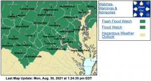
FLASH FLOOD WATCH
Flood Watch
National Weather Service Baltimore MD/Washington DC
1148 AM EDT Mon Aug 30 2021
Charles-Nelson-Albemarle-Orange-Stafford-Central Virginia Blue Ridge-
Including the cities of Wintergreen, St. Charles, Falmouth, Waldorf,
Lovingston, Charlottesville, Orange, and Gordonsville
1148 AM EDT Mon Aug 30 2021
…FLASH FLOOD WATCH IN EFFECT UNTIL 10 PM EDT THIS EVENING…
…FLASH FLOOD WATCH IN EFFECT FROM WEDNESDAY MORNING THROUGH
THURSDAY MORNING…
The National Weather Service in Sterling Virginia has issued a
* Flash Flood Watch for portions of southern Maryland and Virginia,
including the following areas: in southern Maryland, Charles. In
Virginia, Albemarle, Central Virginia Blue Ridge, Nelson, Orange
and Stafford.
* Until 10 PM EDT this evening.
* Scattered to numerous showers and thunderstorms are likely this
afternoon and evening, some of which may produce a few inches of
rain in a short period of time.
* Heavy rainfall in a short period of time would result in rapid
rises of water in small streams and creeks, and in urban and poor
drainage areas.
PRECAUTIONARY/PREPAREDNESS ACTIONS…
You should monitor later forecasts and be prepared to take action
should Flash Flood Warnings be issued.
&&
The National Weather Service in Sterling Virginia has expanded the
* Flash Flood Watch to include portions of southern Maryland and
Virginia, including the following areas: in southern Maryland,
Charles. In Virginia, Albemarle, Central Virginia Blue Ridge,
Nelson, Orange and Stafford.
* From Wednesday morning through Thursday morning.
* The remnants of Ida will interact with a stalled front resulting
periods of showers and thunderstorms with heavy rain beginning
late Wednesday morning and continuing through Wednesday night.
Rainfall amounts of 1 to 2 inches are expected, with localized
amounts around 4 inches possible.
* This amount of heavy rainfall will result in the potential for
flash flooding of creeks and small streams, as well as the
potential for river flooding on the main stem rivers.
PRECAUTIONARY/PREPAREDNESS ACTIONS…
You should monitor later forecasts and be prepared to take action
should Flash Flood Warnings be issued.
Flood Watch
National Weather Service Baltimore MD/Washington DC
1148 AM EDT Mon Aug 30 2021
District of Columbia-Northern Baltimore-Southern Baltimore-Prince
Georges-Anne Arundel-Northwest Montgomery-Central and Southeast
Montgomery-Northwest Howard-Central and Southeast Howard-Northwest
Harford-Southeast Harford-Greene-Madison-Rappahannock-Culpeper-
Prince William/Manassas/Manassas Park-Fairfax-Arlington/Falls
Church/Alexandria-Northern Fauquier-Southern Fauquier-Western
Loudoun-Eastern Loudoun-Northern Virginia Blue Ridge-
Including the cities of Silver Spring, South Gate, Bowie, Arlington,
Annapolis, Manassas, Odenton, Damascus, Falls Church, Purcellville,
Bethesda, Chantilly, Culpeper, Centreville, Sterling, College Park,
Reisterstown, Columbia, Warrenton, Herndon, Severna Park, Greenbelt,
Germantown, Leesburg, McLean, Camp Springs, Rockville,
Jarrettsville, Arnold, Dale City, Big Meadows, Suitland-Silver Hill,
Lake Ridge, Gaithersburg, Severn, Reston, Montclair, Baltimore,
Madison, Alexandria, Clinton, Glen Burnie, Ashburn, Ellicott City,
Woodbridge, Stanardsville, Washington, Annandale, Franconia,
Cockeysville, Lisbon, Laurel, Turnbull, and Aberdeen
1148 AM EDT Mon Aug 30 2021
…FLASH FLOOD WATCH IN EFFECT UNTIL 10 PM EDT THIS EVENING…
…FLASH FLOOD WATCH REMAINS IN EFFECT FROM WEDNESDAY MORNING
THROUGH THURSDAY MORNING…
The National Weather Service in Sterling Virginia has issued a
* Flash Flood Watch for portions of DC, Maryland and Virginia,
including the following areas: in DC, District of Columbia. In
Maryland, Anne Arundel, Central and Southeast Howard, Central and
Southeast Montgomery, Northern Baltimore, Northwest Harford,
Northwest Howard, Northwest Montgomery, Prince Georges, Southeast
Harford and Southern Baltimore. In Virginia, Arlington/Falls
Church/Alexandria, Culpeper, Eastern Loudoun, Fairfax, Greene,
Madison, Northern Fauquier, Northern Virginia Blue Ridge, Prince
William/Manassas/Manassas Park, Rappahannock, Southern Fauquier
and Western Loudoun.
* Until 10 PM EDT this evening.
* Scattered to numerous showers and thunderstorms are likely this
afternoon and evening, some of which may produce a few inches of
rain in a short period of time.
* Heavy rainfall in a short period of time would result in rapid
rises of water in small streams and creeks, and in urban and poor
drainage areas.
PRECAUTIONARY/PREPAREDNESS ACTIONS…
You should monitor later forecasts and be prepared to take action
should Flash Flood Warnings be issued.
&&
The Flash Flood Watch continues for
* Portions of DC, Maryland and Virginia, including the following
areas: in DC, District of Columbia. In Maryland, Anne Arundel,
Central and Southeast Howard, Central and Southeast Montgomery,
Northern Baltimore, Northwest Harford, Northwest Howard, Northwest
Montgomery, Prince Georges, Southeast Harford and Southern
Baltimore. In Virginia, Arlington/Falls Church/Alexandria,
Culpeper, Eastern Loudoun, Fairfax, Greene, Madison, Northern
Fauquier, Northern Virginia Blue Ridge, Prince
William/Manassas/Manassas Park, Rappahannock, Southern Fauquier
and Western Loudoun.
* From Wednesday morning through Thursday morning.
* The remnants of Ida will interact with a stalled front, resulting
in a prolonged period of heavy rainfall beginning Wednesday
morning and continuing through Wednesday night. Rainfall amounts
of 2 to 4 inches are expected, with localized amounts up to 6
inches possible.
* This amount of heavy rainfall will not only result in the
potential for considerable flash flooding of creeks, small
streams, and urban areas, but also the potential for river
flooding on the main stem rivers.
PRECAUTIONARY/PREPAREDNESS ACTIONS…
You should monitor later forecasts and be prepared to take action
should Flash Flood Warnings be issued.
Flood Watch
National Weather Service Baltimore MD/Washington DC
1148 AM EDT Mon Aug 30 2021
Augusta-
Including the cities of Stuarts Draft, Staunton, and Waynesboro
1148 AM EDT Mon Aug 30 2021
…FLASH FLOOD WATCH IN EFFECT UNTIL 10 PM EDT THIS EVENING…
…FLASH FLOOD WATCH IN EFFECT FROM LATE TUESDAY NIGHT THROUGH LATE
WEDNESDAY NIGHT…
The National Weather Service in Sterling Virginia has issued a
* Flash Flood Watch for a portion of western Virginia, including the
following area: Augusta.
* Until 10 PM EDT this evening.
* Scattered to numerous showers and thunderstorms are likely this
afternoon and evening, some of which may produce a few inches of
rain in a short period of time.
* Heavy rainfall in a short period of time would result in rapid
rises of water in small streams and creeks, and in urban and poor
drainage areas.
PRECAUTIONARY/PREPAREDNESS ACTIONS…
You should monitor later forecasts and be prepared to take action
should Flash Flood Warnings be issued.
&&
The National Weather Service in Sterling Virginia has expanded the
* Flash Flood Watch to include a portion of western Virginia,
including the following area: Augusta.
* From late Tuesday night through late Wednesday night.
* The remnants of Ida will interact with a stalled front resulting
periods of showers and thunderstorms with heavy rain beginning
late Wednesday morning and continuing through Wednesday night.
Rainfall amounts of 1 to 2 inches are expected, with localized
amounts around 4 inches possible.
* This amount of heavy rainfall will result in the potential for
flash flooding of creeks and small streams, as well as the
potential for river flooding on the main stem rivers.
PRECAUTIONARY/PREPAREDNESS ACTIONS…
You should monitor later forecasts and be prepared to take action
should Flash Flood Warnings be issued.
