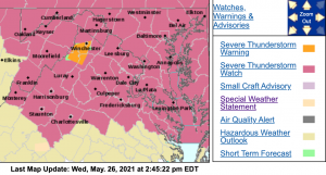
The NWS has issued a Severe Thunderstorm Watch for much of e area until 10 PM this evening. Click image above for the latest updates.
The NWS has issued a Severe Thunderstorm Watch for much of e area until 10 PM this evening. Click image above for the latest updates.
URGENT - IMMEDIATE BROADCAST REQUESTED Severe Thunderstorm Watch Number 206 NWS Storm Prediction Center Norman OK 245 PM EDT Wed May 26 2021 The NWS Storm Prediction Center has issued a * Severe Thunderstorm Watch for portions of Western Connecticut District Of Columbia Delaware Maryland New Jersey Southeast New York Eastern Pennsylvania Northern Virginia Eastern Panhandle of West Virginia Coastal Waters * Effective this Wednesday afternoon and evening from 245 PM until 1000 PM EDT. * Primary threats include... Scattered damaging wind gusts to 70 mph possible Isolated large hail events to 1 inch in diameter possible SUMMARY...Thunderstorms are expected to continue to develop over parts of Pennsylvania and spread eastward across the watch area through the evening hours. Damaging winds will be the main threat with the strongest cells. The severe thunderstorm watch area is approximately along and 65 statute miles north and south of a line from 45 miles northwest of Staunton VA to 5 miles south southeast of Lakehurst NJ. For a complete depiction of the watch see the associated watch outline update (WOUS64 KWNS WOU6). PRECAUTIONARY/PREPAREDNESS ACTIONS... REMEMBER...A Severe Thunderstorm Watch means conditions are favorable for severe thunderstorms in and close to the watch area. Persons in these areas should be on the lookout for threatening weather conditions and listen for later statements and possible warnings. Severe thunderstorms can and occasionally do produce tornadoes.
SEVERE THUNDERSTORM WATCH OUTLINE UPDATE FOR WS 206 NWS STORM PREDICTION CENTER NORMAN OK 245 PM EDT WED MAY 26 2021 SEVERE THUNDERSTORM WATCH 206 IS IN EFFECT UNTIL 1000 PM EDT FOR THE FOLLOWING LOCATIONS ANZ338-430-431-530-531-532-533-534-535-536-537-538-539-540-541- 542-543-630-270200- /O.NEW.KWNS.SV.A.0206.210526T1845Z-210527T0200Z/ CW . ADJACENT COASTAL WATERS INCLUDED ARE NEW YORK HARBOR DELAWARE BAY WATERS NORTH OF EAST POINT NJ TO SLAUGHTER BEACH DE DELAWARE BAY WATERS SOUTH OF EAST POINT NJ TO SLAUGHTER BEACH DE CHESAPEAKE BAY NORTH OF POOLES ISLAND MD CHESAPEAKE BAY FROM POOLES ISLAND TO SANDY POINT MD CHESAPEAKE BAY FROM SANDY POINT TO NORTH BEACH MD CHESAPEAKE BAY FROM NORTH BEACH TO DRUM POINT MD CHESAPEAKE BAY FROM DRUM POINT MD TO SMITH POINT VA TIDAL POTOMAC FROM KEY BRIDGE TO INDIAN HEAD MD TIDAL POTOMAC FROM INDIAN HEAD TO COBB ISLAND MD TIDAL POTOMAC FROM COBB ISLAND MD TO SMITH POINT VA PATAPSCO RIVER INCLUDING BALTIMORE HARBOR CHESTER RIVER TO QUEENSTOWN MD EASTERN BAY CHOPTANK RIVER TO CAMBRIDGE MD AND THE LITTLE CHOPTANK RIVER PATUXENT RIVER TO BROOMES ISLAND MD TANGIER SOUND AND THE INLAND WATERS SURROUNDING BLOODSWORTH ISLAND CHESAPEAKE BAY FROM SMITH POINT TO WINDMILL POINT VA $$ ATTN...WFO...OKX...AKQ...LWX...PHI...
SEVERE THUNDERSTORM WATCH OUTLINE UPDATE FOR WS 206 NWS STORM PREDICTION CENTER NORMAN OK 245 PM EDT WED MAY 26 2021 SEVERE THUNDERSTORM WATCH 206 IS IN EFFECT UNTIL 1000 PM EDT FOR THE FOLLOWING LOCATIONS VAC001-003-013-015-033-043-047-057-059-061-069-079-091-099-103- 107-109-113-125-133-137-139-153-157-159-165-171-177-179-187-193- 510-540-600-610-630-660-683-685-790-820-840-270200- /O.NEW.KWNS.SV.A.0206.210526T1845Z-210527T0200Z/ VA . VIRGINIA COUNTIES INCLUDED ARE ACCOMACK ALBEMARLE ARLINGTON AUGUSTA CAROLINE CLARKE CULPEPER ESSEX FAIRFAX FAUQUIER FREDERICK GREENE HIGHLAND KING GEORGE LANCASTER LOUDOUN LOUISA MADISON NELSON NORTHUMBERLAND ORANGE PAGE PRINCE WILLIAM RAPPAHANNOCK RICHMOND ROCKINGHAM SHENANDOAH SPOTSYLVANIA STAFFORD WARREN WESTMORELAND VIRGINIA INDEPENDENT CITIES INCLUDED ARE ALEXANDRIA CHARLOTTESVILLE FAIRFAX FALLS CHURCH FREDERICKSBURG HARRISONBURG MANASSAS MANASSAS PARK STAUNTON WAYNESBORO WINCHESTER $$

 The NWS has issued a Severe Thunderstorm Watch for much of e area until 10 PM this evening. Click image above for the latest updates.