
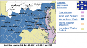
 Via NWS : Most of the area will be under a WINTER STORM WATCH starting late Saturday into Sunday evening. Significant snow accumulations are possible across the area. Click on the image above to see the latest from NWS.
Watches now being upgraded to warnings early Saturday morning.
Appomattox Buckingham:
https://inws.ncep.noaa.gov/a/a.php?i=53640193
Amherst / Rockbridge:
https://inws.ncep.noaa.gov/a/a.php?i=53640642
WINTER STORM WATCH
URGENT – WINTER WEATHER MESSAGE
National Weather Service Baltimore MD/Washington DC
310 PM EST Fri Jan 29 2021
Augusta-Rockingham-Nelson-Albemarle-Western Highland-
Eastern Highland-Central Virginia Blue Ridge-Western Pendleton-
Eastern Pendleton-
310 PM EST Fri Jan 29 2021
…WINTER STORM WATCH IN EFFECT FROM LATE SATURDAY EVENING
THROUGH SUNDAY EVENING…
* WHAT…Heavy snow possible. Potential for 5 or more inches of
snow.
* WHERE…Portions of central Virginia, the central Shenandoah
Valley, as well as Highland County in Virginia and Pendleton
County in West Virginia.
* WHEN…From late Saturday evening through Sunday evening.
* IMPACTS…Travel could be very difficult.
PRECAUTIONARY/PREPAREDNESS ACTIONS…
Monitor the latest forecasts for updates on this situation.
URGENT – WINTER WEATHER MESSAGE
National Weather Service Baltimore MD/Washington DC
310 PM EST Fri Jan 29 2021
District of Columbia-Prince Georges-Anne Arundel-Charles-
St. Marys-Calvert-Northwest Montgomery-
Central and Southeast Montgomery-Northwest Howard-
Central and Southeast Howard-Shenandoah-Frederick VA-Page-Warren-
Clarke-Greene-Madison-Rappahannock-Orange-Culpeper-
Prince William/Manassas/Manassas Park-Fairfax-
Arlington/Falls Church/Alexandria-Stafford-Spotsylvania-
King George-Northern Fauquier-Southern Fauquier-Western Loudoun-
Eastern Loudoun-Northern Virginia Blue Ridge-Jefferson-Hardy-
310 PM EST Fri Jan 29 2021
…WINTER STORM WATCH IN EFFECT FROM LATE SATURDAY NIGHT THROUGH
LATE SUNDAY NIGHT…
* WHAT…Heavy snow possible. Potential for 5 or more inches of
snow.
* WHERE…The District of Columbia, and portions of central and
southern Maryland, central and northern Virginia, and the
eastern panhandle of West Virginia.
* WHEN…From late Saturday night through late Sunday night.
* IMPACTS…Travel could be very difficult.
PRECAUTIONARY/PREPAREDNESS ACTIONS…
Monitor the latest forecasts for updates on this situation.
URGENT – WINTER WEATHER MESSAGE
National Weather Service Blacksburg VA
312 PM EST Fri Jan 29 2021
…Wintry Mix LIkely Saturday Night through Sunday…
.A winter storm will impact the region beginning Saturday night
through at least Sunday night. Precipitation will change from
snow, to sleet, to freezing rain, and possibly back to snow or
rain throughout the event. This wintry mix will make travel
difficult and dangerous.
Ashe-Alleghany NC-Surry-Stokes-Rockingham-Caswell-Watauga-Wilkes-
Yadkin-Tazewell-Smyth-Bland-Giles-Wythe-Pulaski-Montgomery-
Grayson-Carroll-Floyd-Craig-Alleghany VA-Bath-Roanoke-Botetourt-
Rockbridge-Patrick-Franklin-Bedford-Amherst-Henry-Pittsylvania-
Campbell-Appomattox-Buckingham-Halifax-Charlotte-Mercer-Summers-
Monroe-Eastern Greenbrier-Western Greenbrier-
Including the cities of West Jefferson, Sparta, Dobson, Danbury,
Eden, Yanceyville, Boone, Wilkesboro, Yadkinville, Tazewell,
Marion, Bland, Pearisburg, Wytheville, Radford, Pulaski,
Blacksburg, Independence, Whitetop, Troutdale, Volney, Galax,
Floyd, New Castle, Clifton Forge, Covington, Hot Springs,
Roanoke, Salem, Fincastle, Lexington, Buena Vista, Stuart,
Rocky Mount, Amherst, Martinsville, Danville, Lynchburg,
Appomattox, South Boston, Keysville, Bluefield, Hinton, Hix,
Union, Lewisburg, White Sulphur Springs, Quinwood, Duo,
and Rainelle
312 PM EST Fri Jan 29 2021
…WINTER STORM WATCH IN EFFECT FROM SATURDAY EVENING THROUGH
SUNDAY EVENING…
* WHAT…Heavy mixed precipitation possible. Total snow
accumulations of up to 6 inches and ice accumulations of a
light glaze possible.
* WHERE…Portions of central, south central, southwest and west
central Virginia, north central and northwest North Carolina
and southeast West Virginia.
* WHEN…From Saturday evening through Sunday evening.
* IMPACTS…Travel could be very difficult.
PRECAUTIONARY/PREPAREDNESS ACTIONS…
A Winter Storm Watch means there is a potential for significant
snow…sleet…or ice accumulations that may impact travel.
Monitor the latest forecasts for updates on this situation.
