
Latest updates and post by clicking here.
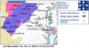
WINTER STORM WARNING / ICE STORM WARNING
Northern Virginia Blue Ridge-Central Virginia Blue Ridge-
1250 PM EST Thu Dec 31 2020
...ICE STORM WARNING IN EFFECT FROM 7 AM TO 10 PM EST FRIDAY…
* WHAT…Significant icing expected. Total ice accumulations of up
to one third of an inch, with the highest amounts in the higher
elevations.
* WHERE…Northern Virginia Blue Ridge and Central Virginia Blue
Ridge.
* WHAT…Significant icing expected. Total ice accumulations of up
to one third of an inch, with the highest amounts in the higher
elevations.
* IMPACTS…Power outages and tree damage are likely due to the
ice. Travel could be nearly impossible. The hazardous conditions
could impact the evening commute.
PRECAUTIONARY/PREPAREDNESS ACTIONS…
Travel is strongly discouraged. If you must travel, keep an extra
flashlight, food and water in your vehicle in case of an
emergency. Prepare for possible power outages.
When venturing outside, watch your first few steps taken on
steps, sidewalks, and driveways, which could be icy and slippery,
increasing your risk of a fall and injury.
Northern Virginia Blue Ridge-Central Virginia Blue Ridge–
1231 PM EST Thu Dec 31 2020
…WINTER STORM WARNING IN EFFECT FROM 7 AM TO 10 PM EST FRIDAY…
* WHAT…Significant icing expected. Total ice accumulations of up
to one third of an inch, with the highest amounts in the higher
elevations.
* WHERE…Northern Virginia Blue Ridge and Central Virginia Blue
Ridge.
* WHEN…From 7 AM to 10 PM EST Friday. Freezing rain will move
into the area Friday morning and then gradually change to rain
Friday afternoon and evening.
* IMPACTS…Power outages and tree damage are likely due to the
ice. Travel could be nearly impossible. The hazardous conditions
could impact the evening commute.
PRECAUTIONARY/PREPAREDNESS ACTIONS…
If you must travel, keep an extra flashlight, food, and water in
your vehicle in case of an emergency. Prepare for possible power
outages.
When venturing outside, watch your first few steps taken on
steps, sidewalks, and driveways, which could be icy and slippery,
increasing your risk of a fall and injury.
WINTER WEATHER ADVISORY
URGENT – WINTER WEATHER MESSAGE
National Weather Service Baltimore MD/Washington DC
1231 PM EST Thu Dec 31 2020
Augusta-Rockingham-Page-Western Highland-Eastern Highland-
Western Pendleton-Eastern Pendleton-
1231 PM EST Thu Dec 31 2020
…WINTER WEATHER ADVISORY IN EFFECT FROM 7 AM TO 10 PM EST
FRIDAY…
* WHAT…Freezing rain expected. Total ice accumulations of up to
two tenths of an inch, with the highest amounts in the higher
elevations.
* WHERE…Portions of northwest and western Virginia and eastern
West Virginia.
* WHEN…From 7 AM to 10 PM EST Friday. Freezing rain will move
into the area Friday morning and then gradually change to rain
Friday afternoon and evening.
* IMPACTS…Difficult travel conditions are possible. The
hazardous conditions could impact the evening commute.
PRECAUTIONARY/PREPAREDNESS ACTIONS…
Slow down and use caution while traveling. Prepare for possible
power outages.
When venturing outside, watch your first few steps taken on
steps, sidewalks, and driveways, which could be icy and slippery,
increasing your risk of a fall and injury.
