

URGENT – WINTER WEATHER MESSAGE
National Weather Service Baltimore MD/Washington DC
310 PM EST Mon Dec 14 2020
Central and Southeast Montgomery-Nelson-Albemarle-Greene-Madison-
Culpeper-Prince William/Manassas/Manassas Park-Fairfax-
Southern Fauquier-
310 PM EST Mon Dec 14 2020
…WINTER STORM WATCH IN EFFECT FROM WEDNESDAY MORNING THROUGH
LATE WEDNESDAY NIGHT…
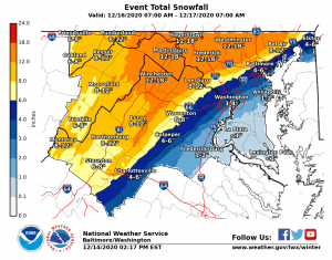
* WHAT…Heavy snow possible. Total snow accumulations greater
than 5 inches possible.
* WHERE…Portions of central Maryland as well as portions
northern and central Virginia
* WHEN…From Wednesday morning through late Wednesday night. Snow
will most likely overspread the area later Wednesday morning
into Wednesday afternoon. Precipitation may mix with rain and
sleet at times later Wednesday afternoon and Wednesday night.
* IMPACTS…Travel could be very difficult to impossible.
PRECAUTIONARY/PREPAREDNESS ACTIONS…
Monitor the latest forecasts for updates on this situation.
URGENT – WINTER WEATHER MESSAGE
National Weather Service Baltimore MD/Washington DC
310 PM EST Mon Dec 14 2020
Garrett-Washington-Frederick MD-Carroll-Northern Baltimore-
Extreme Western Allegany-Central and Eastern Allegany-
Northwest Montgomery-Northwest Howard-Northwest Harford-Augusta-
Rockingham-Shenandoah-Frederick VA-Page-Warren-Clarke-
Rappahannock-Northern Fauquier-Western Highland-Eastern Highland-
Western Loudoun-Eastern Loudoun-Northern Virginia Blue Ridge-
Central Virginia Blue Ridge-Hampshire-Morgan-Berkeley-Jefferson-
Hardy-Western Grant-Eastern Grant-Western Mineral-Eastern Mineral-
Western Pendleton-Eastern Pendleton-
310 PM EST Mon Dec 14 2020
…WINTER STORM WATCH REMAINS IN EFFECT FROM WEDNESDAY MORNING
THROUGH LATE WEDNESDAY NIGHT…
* WHAT…Heavy snow possible. Total snow accumulations greater
than 8 inches possible.
* WHERE…Portions of central, north central, northern and
western Maryland, central, northern, northwest and western
Virginia and eastern and panhandle West Virginia.
* WHEN…From Wednesday morning through late Wednesday night. Snow
will most likely overspread the area later Wednesday morning
into Wednesday afternoon. The heaviest snow is most likely late
Wednesday afternoon through Wednesday evening.
* IMPACTS…Travel could be very difficult. Potential impacts
include significant travel delays and closures. Plan ahead to
minimize impact on you and your family.
PRECAUTIONARY/PREPAREDNESS ACTIONS…
Monitor the latest forecasts for updates on this situation.
URGENT - WINTER WEATHER MESSAGE
National Weather Service Blacksburg VA
226 PM EST Mon Dec 14 2020

...Wintry precipitation possible on Wednesday...

.A complex low pressure system will bring a wintry mix across
portions of the Mid Atlantic on Wednesday. Temperatures will start
below freezing during Wednesday morning due to northeast flow from
a cold wedge of high pressure near the surface. Meanwhile, warmer
air aloft will advance northward over the cold wedge to bring
mixed precipitation. The system should exit by Wednesday evening.


Tazewell-Bland-Giles-Wythe-Pulaski-Montgomery-Carroll-Floyd-Craig-
Alleghany VA-Bath-Roanoke-Botetourt-Rockbridge-Franklin-Bedford-
Amherst-Mercer-Summers-Monroe-Eastern Greenbrier-
Western Greenbrier-
Including the cities of Tazewell, Bland, Pearisburg, Wytheville,
Radford, Pulaski, Blacksburg, Galax, Floyd, New Castle,
Clifton Forge, Covington, Hot Springs, Roanoke, Salem, Fincastle,
Lexington, Buena Vista, Rocky Mount, Amherst, Bluefield, Hinton,
Hix, Union, Lewisburg, White Sulphur Springs, Quinwood, Duo,
and Rainelle
226 PM EST Mon Dec 14 2020

...WINTER STORM WATCH IN EFFECT FROM WEDNESDAY MORNING THROUGH
LATE WEDNESDAY NIGHT...

* WHAT...Mixed precipitation possible. Total snow accumulations of
  2 to 7 inches possible. Ice accumulations up to two tenths of
  an inch possible along the Blue Ridge.

* WHERE...Portions of central, south central, southwest and west
  central Virginia and southeast West Virginia.

* WHEN...From Wednesday morning through late Wednesday night.

* IMPACTS...Travel could be very difficult due to slick roads.
  Isolated power lines and trees may be downed due to the weight
  of snow and ice.

PRECAUTIONARY/PREPAREDNESS ACTIONS...

Monitor the latest forecasts for updates on this situation.
