
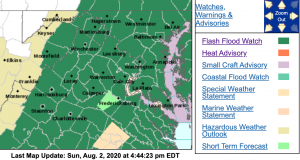
 A Flash Flood Watch is in effect for the areas shaded in green from Monday afternoon into Tuesday evening. For the absolute latest updates from NWS, click on the image above.
Nelson-Albemarle-Greene-Northern Virginia Blue Ridge-
Central Virginia Blue Ridge-
Including the cities of Lovingston, Charlottesville,
Stanardsville, Big Meadows, and Wintergreen
801 AM EDT Tue Aug 4 2020
…FLASH FLOOD WATCH IS CANCELLED…
The Flash Flood Watch for portions of central Virginia and
northwest Virginia has been cancelled.
Flooding rains are no longer expected.
Appomattox-Buckingham-Halifax-Charlotte-
Including the cities of Appomattox, South Boston, and Keysville
643 AM EDT Tue Aug 4 2020
…FLASH FLOOD WATCH IS CANCELLED…
The Flash Flood Watch for portions of central Virginia and south
central Virginia has been cancelled. The threat of flash flooding
producing rains has ended.
FLASH FLOOD WATCH
Flood Watch
National Weather Service Baltimore MD/Washington DC
328 PM EDT Sun Aug 2 2020
Augusta-Rockingham-Shenandoah-Page-Nelson-Albemarle-Greene-
Madison-Rappahannock-Orange-Culpeper-Spotsylvania-
Northern Virginia Blue Ridge-Central Virginia Blue Ridge-Hardy-
Including the cities of Staunton, Waynesboro, Stuarts Draft,
Harrisonburg, Strasburg, Woodstock, Mount Jackson, New Market,
Luray, Shenandoah, Stanley, Lovingston, Charlottesville,
Stanardsville, Madison, Washington, Orange, Gordonsville,
Culpeper, Fredericksburg, Big Meadows, Wintergreen,
and Moorefield
328 PM EDT Sun Aug 2 2020
…FLASH FLOOD WATCH IN EFFECT FROM MONDAY AFTERNOON THROUGH
TUESDAY EVENING…
The National Weather Service in Sterling Virginia has issued a
* Flash Flood Watch for portions of Virginia and eastern West
Virginia, including the following areas, in Virginia,
Albemarle, Augusta, Central Virginia Blue Ridge, Culpeper,
Greene, Madison, Nelson, Northern Virginia Blue Ridge, Orange,
Page, Rappahannock, Rockingham, Shenandoah, and Spotsylvania.
In eastern West Virginia, Hardy.
* From Monday afternoon through Tuesday evening.
* Rainfall associated with Tropical Storm Isaias is expected to
start spreading northward late Monday afternoon and continue
through much of the day on Tuesday. Widespread rainfall totals
of 3 to 6 inches are expected with localized higher amounts
possible.
* This amount of rain is likely to result in significant flash
flooding of small streams and creeks Monday night into Tuesday
evening.
PRECAUTIONARY/PREPAREDNESS ACTIONS…
A Flash Flood Watch means that conditions may develop that lead
to flash flooding. Flash flooding is a very dangerous situation.
You should monitor later forecasts and be prepared to take action
should Flash Flood Warnings be issued.
Flood Watch
National Weather Service Blacksburg VA
314 PM EDT Sun Aug 2 2020
…Heavy Rainfall Expected Monday through Tuesday Combination of
Stalled Frontal Systems and Outer Effects of Tropical Storm
Isaias…
.Significant amounts of rainfall are expected to begin across the
forecast area after midnight tonight and increase through the day
Monday into Tuesday as a result of a stalled frontal system
across the area, firmly entrenched deep tropical moisture, and
the outer circulation of now Tropical Storm Isaias moving
northward from along the central and northern Florida East Coast
today to just east of Danville by Tuesday morning. Upslope east
flow along the Blue Ridge later tonight and Monday combined with
an increasing fetch of tropical moisture associated with the
outer circulation of Isaias as it moves northward and then
further enhanced with disturbances aloft and the proximity of the
stalled frontal system over the area could lead to excessive
amounts of rainfall across parts of the forecast area. One area
that seems likely to see excessive amounts of rain, in the 2-
4 inch range, are the eastern slopes of Blue Ridge Mountains,
particularly from Watauga County NC northeastward toward
Rockbridge County VA. The other area that could see excessive
amounts of rain will be Southside Virginia into the Virginia and
North Carolina Piedmont or roughly the Danville, Lynchburg,
Martinsville, and Reidsville areas as the core of Isaias passes
just east of Danville early Tuesday. In these areas, 2-4 inches of
rain are likely through Tuesday with locally higher amounts. Most
of the rain in this area will occur Monday afternoon through
Tuesday morning.
Small creeks and streams could rise into flood quickly by Monday
afternoon in areas of heavy rainfall. The Watauga River and its
tributaries in western NC will be subject to flooding as early as
Monday morning. Larger main stem river flooding is less likely,
but at least minor flooding could be expected on the Dan River
basin and its tributaries later in the week.
Stokes-Yadkin-Roanoke-Botetourt-Rockbridge-Franklin-Bedford-
Amherst-Appomattox-Buckingham–
Including the cities of Danbury, Yadkinville, Roanoke, Salem,
Fincastle, Lexington, Buena Vista, Rocky Mount, Bedford, Amherst,
and Appomattox
314 PM EDT Sun Aug 2 2020
…FLASH FLOOD WATCH IN EFFECT FROM MONDAY AFTERNOON THROUGH
TUESDAY EVENING…
The National Weather Service in Blacksburg has expanded the
* Flash Flood Watch to include portions of North Carolina and
Virginia, including the following areas, in North Carolina,
Stokes and Yadkin. In Virginia, Amherst, Appomattox, Bedford,
Botetourt, Buckingham, Franklin, Roanoke, and Rockbridge.
* From Monday afternoon through Tuesday evening
* Excessive rainfall enhanced by the remnants of Tropical Storm
Isaias
* Small creeks and streams could rise into flood quickly on
Monday. Flash flooding can be expected in areas of quick heavy
rainfall and areas of persistent moderate or heavier rainfall.
From 2 to 4 inches of rainfall is expected in the included
counties, with locally higher amounts possible.
PRECAUTIONARY/PREPAREDNESS ACTIONS…
A Flash Flood Watch means that conditions may develop that lead
to flash flooding. Flash flooding is a VERY DANGEROUS SITUATION.
Remember…TURN AROUND…DON`T DROWN!
You should monitor later forecasts and be prepared to take action
should Flash Flood Warnings be issued.
