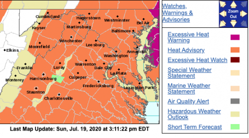


HEAT ADVISORY
URGENT – WEATHER MESSAGE
National Weather Service Baltimore MD/Washington DC
247 PM EDT Sun Jul 19 2020
Washington-Frederick MD-Carroll-Northern Baltimore-
Northwest Montgomery-Northwest Howard-Northwest Harford-
Shenandoah-Frederick VA-Page-Warren-Clarke-Nelson-Albemarle-
Greene-Madison-Rappahannock-Orange-Culpeper-Northern Fauquier-
Southern Fauquier-Western Loudoun-Eastern Loudoun-Hampshire-
Morgan-Berkeley-Jefferson-Hardy-
Including the cities of Hagerstown, Frederick, Ballenger Creek,
Eldersburg, Westminster, Reisterstown, Cockeysville, Germantown,
Damascus, Lisbon, Jarrettsville, Strasburg, Woodstock,
Mount Jackson, New Market, Winchester, Luray, Shenandoah,
Stanley, Front Royal, Berryville, Lovingston, Charlottesville,
Stanardsville, Madison, Washington, Orange, Gordonsville,
Culpeper, Warrenton, Turnbull, Purcellville, Leesburg, Ashburn,
Sterling, Romney, Paw Paw, Martinsburg, Charles Town,
Shepherdstown, and Moorefield
247 PM EDT Sun Jul 19 2020
…HEAT ADVISORY REMAINS IN EFFECT UNTIL 8 PM EDT THIS EVENING…
…HEAT ADVISORY IN EFFECT FROM NOON TO 8 PM EDT MONDAY…
The National Weather Service in Baltimore MD/Washington has
issued a Heat Advisory, which is in effect from noon to 8 PM EDT
Monday.
* WHAT…Heat index values from 100 to 103 west of the Blue Ridge
Mountains. Heat index values to around 106 east of the Blue
Ridge Mountains.
* WHERE…Portions of The District of Columbia, central,
northern and western Maryland, northern and northwest
Virginia, as well as the eastern panhandle of West Virginia.
* WHEN…From noon today to 8 PM EDT this evening, and again from
noon to 8 PM EDT Monday.
* Impacts…Hot temperatures and high humidity may cause heat
illnesses to occur.
PRECAUTIONARY/PREPAREDNESS ACTIONS…
Drink plenty of fluids, stay in an air-conditioned room, stay out
of the sun, and check up on relatives and neighbors. Young
children and pets should never be left unattended in vehicles
under any circumstances.
Take extra precautions if you work or spend time outside. When
possible reschedule strenuous activities to early morning or
evening. Know the signs and symptoms of heat exhaustion and heat
stroke. Wear lightweight and loose fitting clothing when
possible. To reduce risk during outdoor work, the Occupational
Safety and Health Administration recommends scheduling frequent
rest breaks in shaded or air conditioned environments. Anyone
overcome by heat should be moved to a cool and shaded location.
Heat stroke is an emergency! Call 9 1 1.
CDC recommends that if you need to go to a cooling center, wear a
cloth face covering. While you are there, wash your hands with
soap, or use hand sanitizer, often. Face covers should not be
used by children under the age of 2. They also should not be used
by people having trouble breathing, or who are unconscious,
injured, or can`t remove the mask themselves.
A Heat Advisory means that a period of high temperatures is
expected. The combination of high temperatures and high humidity
will create a situation in which heat illnesses are possible.
Take extra precautions if you work or spend time outside. When
possible, reschedule strenuous activities to early morning or
evening. Know the signs and symptoms of heat exhaustion and heat
stroke. Wear light weight and loose fitting clothing when
possible and drink plenty of water.
To reduce risk during outdoor work, the Occupational Safety and
Health Administration recommends scheduling frequent rest breaks
in shaded or air conditioned environments. Anyone overcome by
heat should be moved to a cool and shaded location. Heat stroke
is an emergency – call 911.
&&
URGENT – WEATHER MESSAGE
National Weather Service Baltimore MD/Washington DC
247 PM EDT Sun Jul 19 2020
Augusta-Rockingham-
Including the cities of Staunton, Waynesboro, Stuarts Draft,
and Harrisonburg
247 PM EDT Sun Jul 19 2020
…HEAT ADVISORY IN EFFECT FROM NOON TO 8 PM EDT MONDAY…
The National Weather Service in Baltimore MD/Washington has
issued a Heat Advisory, which is in effect from noon to 8 PM EDT
Monday.
* WHAT…Heat index values from 100 to 103 west of the Blue Ridge
Mountains.
* WHERE…Portions of the central Shenandoah Valley.
* WHEN…From noon to 8 PM EDT Monday.
* Impacts…Hot temperatures and high humidity may cause heat
illnesses to occur.
PRECAUTIONARY/PREPAREDNESS ACTIONS…
A Heat Advisory means that a period of high temperatures is
expected. The combination of high temperatures and high humidity
will create a situation in which heat illnesses are possible.
Take extra precautions if you work or spend time outside. When
possible, reschedule strenuous activities to early morning or
evening. Know the signs and symptoms of heat exhaustion and heat
stroke. Wear light weight and loose fitting clothing when
possible and drink plenty of water.
To reduce risk during outdoor work, the Occupational Safety and
Health Administration recommends scheduling frequent rest breaks
in shaded or air conditioned environments. Anyone overcome by
heat should be moved to a cool and shaded location. Heat stroke
is an emergency – call 911.
URGENT – WEATHER MESSAGE
National Weather Service Blacksburg VA
304 PM EDT Sun Jul 19 2020
Rockingham-Caswell-Roanoke-Franklin-Bedford-Amherst-Henry-
Pittsylvania-Campbell-Appomattox-Buckingham-Halifax-Charlotte-
Including the cities of Eden, Yanceyville, Roanoke, Salem,
Rocky Mount, Bedford, Amherst, Martinsville, Danville, Lynchburg,
Appomattox, South Boston, and Keysville
304 PM EDT Sun Jul 19 2020
…HEAT ADVISORY REMAINS IN EFFECT UNTIL 9 PM EDT THIS EVENING…
…HEAT ADVISORY IN EFFECT FROM 1 PM TO 9 PM EDT MONDAY…
* WHAT…For the first Heat Advisory, heat index values up to
106. For the second Heat Advisory, heat index values up to 108
expected.
* WHERE…Portions of central, south central and west central
Virginia and north central North Carolina.
* WHEN…For the first Heat Advisory, until 9 PM EDT this
evening. For the second Heat Advisory, from 1 PM to 9 PM EDT
Monday.
* IMPACTS…Hot temperatures and high humidity may cause heat
illnesses to occur.
PRECAUTIONARY/PREPAREDNESS ACTIONS…
Drink plenty of fluids, stay in an air-conditioned room, stay out
of the sun, and check up on relatives and neighbors. Young
children and pets should never be left unattended in vehicles
under any circumstances.
Take extra precautions if you work or spend time outside. When
possible reschedule strenuous activities to early morning or
evening. Know the signs and symptoms of heat exhaustion and heat
stroke. Wear lightweight and loose fitting clothing when
possible. To reduce risk during outdoor work, the Occupational
Safety and Health Administration recommends scheduling frequent
rest breaks in shaded or air conditioned environments. Anyone
overcome by heat should be moved to a cool and shaded location.
Heat stroke is an emergency! Call 9 1 1.
CDC recommends that if you need to go to a cooling center, wear a
cloth face covering. While you are there, wash your hands with
soap, or use hand sanitizer, often. Face covers should not be
used by children under the age of 2. They also should not be used
by people having trouble breathing, or who are unconscious,
injured, or can`t remove the mask themselves.

