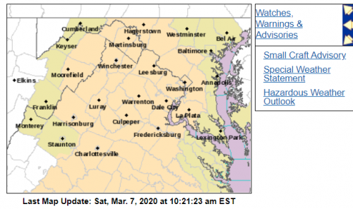
Rapid Wildland Fire Growth Potential Today
Special Weather Statement
National Weather Service Baltimore MD/Washington DC
948 AM EST Sat Mar 7 2020
District of Columbia-Washington-Frederick MD-Prince Georges-
Charles-Northwest Montgomery-Central and Southeast Montgomery-
Northwest Howard-Central and Southeast Howard-Rockingham-
Shenandoah-Frederick VA-Page-Warren-Clarke-Nelson-Albemarle–
Greene-Madison-Rappahannock-Orange-Culpeper-
Prince William/Manassas/Manassas Park-Fairfax-
Arlington/Falls Church/Alexandria-Stafford-Spotsylvania-
King George-Northern Fauquier-Southern Fauquier-Western Loudoun-
Eastern Loudoun-Northern Virginia Blue Ridge-
Central Virginia Blue Ridge-Hampshire-Morgan-Berkeley-Jefferson-
Hardy-
Including the cities of Washington, Hagerstown, Frederick,
Ballenger Creek, Bowie, Suitland-Silver Hill, Clinton,
College Park, Greenbelt, Laurel, Camp Springs, St. Charles,
Waldorf, Germantown, Damascus, Bethesda, Rockville, Gaithersburg,
Silver Spring, Lisbon, Columbia, Ellicott City, Harrisonburg,
Strasburg, Woodstock, Mount Jackson, New Market, Winchester,
Luray, Shenandoah, Stanley, Front Royal, Berryville, Lovingston,
Charlottesville, Stanardsville, Madison, Orange, Gordonsville,
Culpeper, Dale City, Manassas, Woodbridge, Lake Ridge, Montclair,
Reston, Herndon, Annandale, Centreville, Chantilly, McLean,
Franconia, Arlington, Alexandria, Falls Church, Falmouth,
Fredericksburg, Dahlgren, Warrenton, Turnbull, Purcellville,
Leesburg, Ashburn, Sterling, Big Meadows, Wintergreen, Romney,
Paw Paw, Martinsburg, Charles Town, Shepherdstown, and Moorefield
948 AM EST Sat Mar 7 2020
…Rapid Wildland Fire Growth Potential Today…
Gusty winds and rapidly lowering humidity will result in an
enhanced risk of rapid wildland fire growth today. Humidity will
drop below 30 percent across most of the region by this afternoon,
with sustained winds of 15 to 20 mph and gusts up to 30 mph.
The combination of gusty winds and low humidity may allow small
fires to rapidly grow if they escape control. Anyone with outdoor
plans involving fire should use extreme caution today.
Though humidity will again be very low on Sunday, the winds will
be much lighter. Thus, the fire danger will be lower.
Special Weather Statement
National Weather Service Blacksburg VA
927 AM EST Sat Mar 7 2020
Patrick-Franklin-Bedford-Amherst-Henry-Pittsylvania-Campbell-
Appomattox-Buckingham-Halifax-Charlotte-
Including the cities of Stuart, Rocky Mount, Bedford, Amherst,
Martinsville, Danville, Lynchburg, Appomattox, South Boston,
and Keysville
927 AM EST Sat Mar 7 2020
…Increased fire danger across southwest Virginia…
Gusty winds and low relative humidity levels will enhance the
threat for wildfires this afternoon.
Virginia residents are reminded that open burning is prohibited
before 4 pm each day through April 30th.
Use extra caution when handling any potential ignition source…
including machinery…cigarettes…and matches. Be sure to properly
discard all smoking materials. Any fires that do start will have
the potential to spread quickly.


