
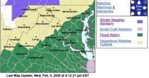
 For the absolute latest updates from NWS click on the map image above. .
St. Marys-Calvert-Augusta-Nelson-Albemarle-Spotsylvania-
King George-Central Virginia Blue Ridge-
Including the cities of Lexington Park, California,
Chesapeake Beach, Huntingtown, Dunkirk, North Beach, Lusby,
Prince Frederick, Staunton, Waynesboro, Stuarts Draft,
Lovingston, Charlottesville, Fredericksburg, Dahlgren,
and Wintergreen
203 AM EST Fri Feb 7 2020
…FLOOD WATCH IS CANCELLED…
The Flood Watch for portions of southern Maryland and Virginia
has been cancelled. Moderate rain is exiting, and the threat for
flooding is diminishing.
FLOOD WATCH
Flood Watch
National Weather Service Baltimore MD/Washington DC
323 PM EST Wed Feb 5 2020
District of Columbia-Southern Baltimore-Prince Georges-
Anne Arundel-Charles-St. Marys-Calvert-
Central and Southeast Montgomery-Central and Southeast Howard-
Southeast Harford-Augusta-Nelson-Albemarle-Greene-Madison-Orange-
Culpeper-Prince William/Manassas/Manassas Park-Fairfax-
Arlington/Falls Church/Alexandria-Stafford-Spotsylvania-
King George-Southern Fauquier-Central Virginia Blue Ridge–
Including the cities of Washington, Baltimore, Bowie,
Suitland-Silver Hill, Clinton, College Park, Greenbelt, Laurel,
Camp Springs, Glen Burnie, Annapolis, Severn, South Gate,
Severna Park, Arnold, Odenton, St. Charles, Waldorf,
Lexington Park, California, Chesapeake Beach, Huntingtown,
Dunkirk, North Beach, Lusby, Prince Frederick, Bethesda,
Rockville, Gaithersburg, Silver Spring, Columbia, Ellicott City,
Aberdeen, Staunton, Waynesboro, Stuarts Draft, Lovingston,
Charlottesville, Stanardsville, Madison, Orange, Gordonsville,
Culpeper, Dale City, Manassas, Woodbridge, Lake Ridge, Montclair,
Reston, Herndon, Annandale, Centreville, Chantilly, McLean,
Franconia, Arlington, Alexandria, Falls Church, Falmouth,
Fredericksburg, Dahlgren, Turnbull, and Wintergreen
323 PM EST Wed Feb 5 2020
…FLOOD WATCH IN EFFECT FROM THURSDAY AFTERNOON THROUGH FRIDAY
MORNING…
* From Thursday afternoon through Friday morning
* Multiple rounds of rainfall will occur through early Friday. The
heaviest rainfall potential will begin Thursday afternoon and
continue into Thursday night. Storm total rainfall amounts
through Friday morning are expected to range between 2 and 3
inches.
* Flooding of poor drainage and low lying areas will be possible,
and some smaller streams and rivers may exceed their banks.
PRECAUTIONARY/PREPAREDNESS ACTIONS…
A Flood Watch means there is a potential for flooding based on
current forecasts.
You should monitor later forecasts and be alert for possible
Flood Warnings. Those living in areas prone to flooding should be
prepared to take action should flooding develop.
Flood Watch
National Weather Service Blacksburg VA
256 PM EST Wed Feb 5 2020
… Flood Watch Tonight through Friday Morning…
Tazewell-Smyth-Bland-Giles-Wythe-Pulaski-Montgomery-Craig-
Alleghany VA-Bath-Roanoke-Botetourt-Rockbridge-Mercer-Summers-
Monroe-Eastern Greenbrier-Western Greenbrier-
Including the cities of Tazewell, Marion, Bland, Pearisburg,
Wytheville, Radford, Pulaski, Blacksburg, New Castle,
Clifton Forge, Covington, Hot Springs, Roanoke, Salem, Fincastle,
Lexington, Buena Vista, Bluefield, Flat Top, Hinton, Hix, Union,
Lewisburg, White Sulphur Springs, Alderson, Quinwood, Duo,
and Rainelle
256 PM EST Wed Feb 5 2020
…FLOOD WATCH REMAINS IN EFFECT FROM MIDNIGHT EST TONIGHT
THROUGH FRIDAY MORNING…
The Flood Watch continues for
* Portions of Virginia and southeast West Virginia, including
the following areas, in Virginia, Alleghany VA, Bath, Bland,
Botetourt, Craig, Giles, Montgomery, Pulaski, Roanoke,
Rockbridge, Smyth, Tazewell, and Wythe. In southeast West
Virginia, Eastern Greenbrier, Mercer, Monroe, Summers, and
Western Greenbrier.
* From midnight EST tonight through Friday morning
* An extended period of rainfall with high rainfall rates and
thunderstorms on Thursday create favorable conditions for
flooding. Rainfall totals of 2 to 3 inches are expected with
locally higher amounts possible.
* The ground will be saturated when thunderstorms are most
likely. High rainfall rates inside of these storms could
potentially create rapid water rises, especially in small
creeks and streams, areas with poor drainage, and low lying
areas.
PRECAUTIONARY/PREPAREDNESS ACTIONS…
A Flood Watch means there is a potential for flooding based on
current forecasts.
You should monitor later forecasts and be alert for possible
Flood Warnings. Those living in areas prone to flooding should be
prepared to take action should flooding develop.
Flood Watch
National Weather Service Blacksburg VA
256 PM EST Wed Feb 5 2020
… Flood Watch Tonight through Friday Morning…
Ashe-Alleghany NC-Surry-Stokes-Rockingham-Caswell-Watauga-Wilkes-
Yadkin-Grayson-Carroll-Floyd-Patrick-Franklin-Bedford-Amherst-
Henry-Pittsylvania-Campbell-Appomattox-Buckingham-Halifax-
Charlotte-
Including the cities of West Jefferson, Sparta, Dobson, Danbury,
Eden, Yanceyville, Boone, Wilkesboro, Yadkinville, Independence,
Whitetop, Troutdale, Volney, Galax, Floyd, Stuart, Rocky Mount,
Bedford, Amherst, Martinsville, Danville, Lynchburg, Appomattox,
South Boston, and Keysville
256 PM EST Wed Feb 5 2020
…FLOOD WATCH REMAINS IN EFFECT FROM MIDNIGHT EST TONIGHT
THROUGH FRIDAY MORNING…
The Flood Watch continues for
* Portions of North Carolina and Virginia, including the
following areas, in North Carolina, Alleghany NC, Ashe,
Caswell, Rockingham, Stokes, Surry, Watauga, Wilkes, and
Yadkin. In Virginia, Amherst, Appomattox, Bedford, Buckingham,
Campbell, Carroll, Charlotte, Floyd, Franklin, Grayson,
Halifax, Henry, Patrick, and Pittsylvania.
* From midnight EST tonight through Friday morning
* An extended period of rainfall with high rainfall rates and
thunderstorms on Thursday create favorable conditions for
flooding. Rainfall totals of 3 to 4 inches with locally higher
amounts over 5 inches possible along the Blue Ridge.
* The ground will be saturated when thunderstorms are most
likely. High rainfall rates inside of these storms could
potentially create rapid water rises, especially in small
creeks and streams, areas with poor drainage, and low lying
areas.
PRECAUTIONARY/PREPAREDNESS ACTIONS…
A Flood Watch means there is a potential for flooding based on
current forecasts.
You should monitor later forecasts and be alert for possible
Flood Warnings. Those living in areas prone to flooding should be
prepared to take action should flooding develop.
