
WINTER WEATHER ADVISORY AREA EXPANDED FOR TUESDAY. Click here for that update.
URGENT – WINTER WEATHER MESSAGE
National Weather Service Blacksburg VA
335 AM EST Mon Jan 6 2020
…Accumulating Snow Likely on Tuesday…
.A vigorous upper-level disturbance will move across the
region Tuesday, moving east of the forecast area by Tuesday
evening. This disturbance will combine with ample moisture and
below freezing temperatures Tuesday morning to bring a quick
round of snow to the area beginning in the west just before
daybreak spreading into the eastern areas by mid to late morning,
then tapering off from the west during the afternoon.
Snow accumulations of 1 to 3 inches will be possible generally
along and northwest of a line from Boone, to Hillsville, to
Roanoke, to Lynchburg. South of this line, mixed winter
precipitation of sleet and snow is expected with total
accumulations of winter precipitation expected to be less than 1
inch before the precipitation mixes with and changes to rain
during the late morning and early afternoon. Isolated 4 inch snow
totals will be possible near the North Carolina/Tennessee/Virginia
border from Boone to Whitetop, as well as in West Virginia from
Flat Top to Rainelle and Quinwood.
Giles-Pulaski-Montgomery-Carroll-Floyd-Craig-Alleghany VA-Bath-
Roanoke-Botetourt-Rockbridge-Franklin-Bedford-Amherst-Campbell-
Summers-Monroe-Eastern Greenbrier-Western Greenbrier-
Including the cities of Pearisburg, Radford, Pulaski, Blacksburg,
Galax, Floyd, New Castle, Clifton Forge, Covington, Hot Springs,
Roanoke, Salem, Fincastle, Lexington, Buena Vista, Rocky Mount,
Amherst, Lynchburg, Hinton, Hix, Union, Lewisburg,
White Sulphur Springs, Quinwood, Duo, and Rainelle
335 AM EST Mon Jan 6 2020
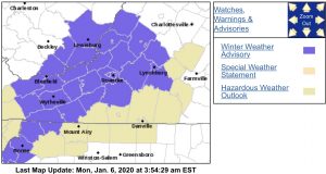
…WINTER WEATHER ADVISORY IN EFFECT FROM 7 AM TO 4 PM EST
TUESDAY…
* WHAT…Mostly snow, but some sleet expected. Total snow and
sleet accumulations of 1 to 3 inches.
* WHERE…Portions of central, south central, southwest and west
central Virginia and southeast West Virginia.
* WHEN…From 7 AM to 4 PM EST Tuesday.
* IMPACTS…Plan on slippery road conditions. The hazardous
conditions could impact the morning and afternoon commute.
PRECAUTIONARY/PREPAREDNESS ACTIONS…
Slow down and use caution while traveling. Untreated roads and
walkways will become snow and sleet covered and thus hazardous.
The latest road conditions for the state you are calling from can
be obtained by calling 5 1 1.
