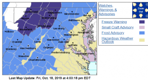
Via NWS : A frost advisory has been issued for much of the Central Virginia Blue Ridge area from 2 AM until 9 AM Saturday morning. Click on image above for latest updates from NWS.
Via NWS : A frost advisory has been issued for much of the Central Virginia Blue Ridge area from 2 AM until 9 AM Saturday morning. Click on image above for latest updates from NWS.
URGENT - WEATHER MESSAGE
National Weather Service Baltimore MD/Washington DC
413 PM EDT Fri Oct 18 2019

Frederick MD-Carroll-Northern Baltimore-Northwest Montgomery-
Central and Southeast Montgomery-Northwest Howard-
Central and Southeast Howard-Northwest Harford-Augusta-Rockingham-
Shenandoah-Page-Warren-Nelson-Albemarle-Greene-Madison-
Rappahannock-Orange-Culpeper-
Prince William/Manassas/Manassas Park-Fairfax-Stafford-
Northern Fauquier-Southern Fauquier-Western Highland-
Eastern Highland-Western Loudoun-Eastern Loudoun-
Western Pendleton-Eastern Pendleton-
Including the cities of Frederick, Ballenger Creek, Eldersburg,
Westminster, Reisterstown, Cockeysville, Germantown, Damascus,
Bethesda, Rockville, Gaithersburg, Silver Spring, Lisbon,
Columbia, Ellicott City, Jarrettsville, Staunton, Waynesboro,
Stuarts Draft, Harrisonburg, Strasburg, Woodstock, Mount Jackson,
New Market, Luray, Shenandoah, Stanley, Front Royal, Lovingston,
Charlottesville, Stanardsville, Madison, Washington, Orange,
Gordonsville, Culpeper, Dale City, Manassas, Woodbridge,
Lake Ridge, Montclair, Reston, Herndon, Annandale, Centreville,
Chantilly, McLean, Franconia, Falmouth, Warrenton, Turnbull,
Hightown, Monterey, Purcellville, Leesburg, Ashburn, Sterling,
Riverton, Brandywine, Franklin, Oak Flat, Ruddle, and Sugar Grove
413 PM EDT Fri Oct 18 2019

...FROST ADVISORY REMAINS IN EFFECT FROM 2 AM TO 9 AM EDT
SATURDAY...

* WHAT...Temperatures as low as 33 will result in frost
  formation.

* WHERE...Portions of central, north central and northern
  Maryland, central, northern, northwest and western Virginia
  and eastern West Virginia.

* WHEN...From 2 AM to 9 AM EDT Saturday.

* IMPACTS...Frost could kill sensitive outdoor vegetation if
  left uncovered.

PRECAUTIONARY/PREPAREDNESS ACTIONS...

Take steps now to protect tender plants from the cold.
URGENT - WEATHER MESSAGE
National Weather Service Blacksburg VA
252 PM EDT Fri Oct 18 2019

Ashe-Alleghany NC-Watauga-Tazewell-Smyth-Bland-Giles-Wythe-
Pulaski-Montgomery-Grayson-Carroll-Floyd-Craig-Alleghany VA-Bath-
Roanoke-Botetourt-Rockbridge-Bedford-Amherst-Campbell-Appomattox-
Buckingham-Mercer-Summers-Monroe-Eastern Greenbrier-
Western Greenbrier-
Including the cities of West Jefferson, Sparta, Boone, Tazewell,
Marion, Bland, Pearisburg, Wytheville, Radford, Pulaski,
Blacksburg, Independence, Whitetop, Troutdale, Volney, Galax,
Floyd, New Castle, Clifton Forge, Covington, Hot Springs,
Roanoke, Salem, Fincastle, Lexington, Buena Vista, Bedford,
Amherst, Lynchburg, Appomattox, Bluefield, Flat Top, Hinton, Hix,
Union, Lewisburg, White Sulphur Springs, Alderson, Quinwood, Duo,
and Rainelle
252 PM EDT Fri Oct 18 2019

...FROST ADVISORY REMAINS IN EFFECT FROM 2 AM TO 9 AM EDT
SATURDAY...

* WHAT...Temperatures as low as around 35 will result in frost
  formation.

* WHERE...Portions of central, south central, southwest and west
  central Virginia and southeast West Virginia.

* WHEN...From 2 AM to 9 AM EDT Saturday.

* IMPACTS...Frost could kill sensitive outdoor vegetation if
  left uncovered.

PRECAUTIONARY/PREPAREDNESS ACTIONS...

Take steps now to protect tender plants from the cold.

