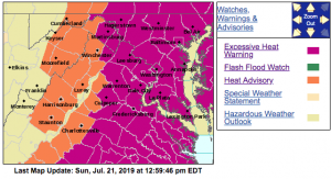
Via NWS : HEAT ADVISORY & EXCESSIVE HEAT WARNING continues into the evening. Click on image above for absolute latest updates from NWS.
Via NWS : HEAT ADVISORY or EXCESSIVE HEAT WARNING continues into the evening. Click on image above for absolute latest updates from NWS.
URGENT - WEATHER MESSAGE
National Weather Service Baltimore MD/Washington DC
549 AM EDT Sun Jul 21 2019

MDZ502-VAZ025>030-WVZ050-051-055-502-504-211800-
/O.CON.KLWX.HT.Y.0004.190721T1500Z-190722T0100Z/
Central and Eastern Allegany-Augusta-Rockingham-Shenandoah-
Frederick VA-Page-Warren-Hampshire-Morgan-Hardy-Eastern Grant-
Eastern Mineral-
Including the cities of Cumberland, Staunton, Waynesboro,
Stuarts Draft, Harrisonburg, Strasburg, Woodstock, Mount Jackson,
New Market, Winchester, Luray, Shenandoah, Stanley, Front Royal,
Romney, Paw Paw, Moorefield, Petersburg, Antioch, Keyser,
New Creek, Ridgeville, Russelldale, Headsville, and Fort Ashby
549 AM EDT Sun Jul 21 2019

...HEAT ADVISORY REMAINS IN EFFECT FROM 11 AM THIS MORNING TO
9 PM EDT THIS EVENING...

* HEAT INDEX VALUES..Around 100 degrees to temperatures in the
  mid 90s, and dewpoints in the lower 70s.

* IMPACTS...The heat and humidity may cause heat stress during
  outdoor exertion or extended exposure.

PRECAUTIONARY/PREPAREDNESS ACTIONS...

A Heat Advisory means that a period of high temperatures is
expected. The combination of high temperatures and high humidity
will create a situation in which heat illnesses are possible.

Take extra precautions if you work or spend time outside. When
possible, reschedule strenuous activities to early morning or
evening. Know the signs and symptoms of heat exhaustion and heat
stroke. Wear light weight and loose fitting clothing when
possible and drink plenty of water.

To reduce risk during outdoor work, the Occupational Safety and
Health Administration recommends scheduling frequent rest breaks
in shaded or air conditioned environments. Anyone overcome by
heat should be moved to a cool and shaded location. Heat stroke
is an emergency - call 911.

&&

$$
URGENT - WEATHER MESSAGE
National Weather Service Baltimore MD/Washington DC
549 AM EDT Sun Jul 21 2019

VAZ036>040-211800-
/O.CON.KLWX.HT.Y.0004.190721T1500Z-190722T0100Z/
Nelson-Albemarle-Greene-Madison-Rappahannock-
Including the cities of Lovingston, Charlottesville,
Stanardsville, Madison, and Washington
549 AM EDT Sun Jul 21 2019

...HEAT ADVISORY REMAINS IN EFFECT FROM 11 AM THIS MORNING TO
9 PM EDT THIS EVENING...

* HEAT INDEX VALUES...Around 105 degrees due to temperatures in
  the upper 90s, and dewpoints in the lower 70s.

* IMPACTS...The heat and humidity may cause heat stress during
  outdoor exertion or extended exposure.

  PRECAUTIONARY/PREPAREDNESS ACTIONS...

A Heat Advisory means that a period of high temperatures is
expected. The combination of high temperatures and high humidity
will create a situation in which heat illnesses are possible.

Take extra precautions if you work or spend time outside. When
possible, reschedule strenuous activities to early morning or
evening. Know the signs and symptoms of heat exhaustion and heat
stroke. Wear light weight and loose fitting clothing when
possible and drink plenty of water.

To reduce risk during outdoor work, the Occupational Safety and
Health Administration recommends scheduling frequent rest breaks
in shaded or air conditioned environments. Anyone overcome by
heat should be moved to a cool and shaded location. Heat stroke
is an emergency - call 911.
URGENT - WEATHER MESSAGE
National Weather Service Blacksburg VA
553 AM EDT Sun Jul 21 2019

...Excessive Heat Expected This Afternoon...

.Strong high pressure aloft will remain across the region through
this evening resulting in another afternoon and evening of above
normal temperatures. High temperatures will once again climb into
the mid to upper 90s. Combine this with dewpoints in the lower to
mid 70s and the heat index will rise to values in the 105 to 110
degree range.


NCZ005-006-VAZ034-035-044-045-212100-
/O.CON.KRNK.HT.Y.0002.000000T0000Z-190722T0300Z/
Rockingham-Caswell-Bedford-Amherst-Pittsylvania-Campbell-
Including the cities of Eden, Yanceyville, Bedford, Amherst,
Danville, and Lynchburg
553 AM EDT Sun Jul 21 2019

...HEAT ADVISORY REMAINS IN EFFECT UNTIL 11 PM EDT THIS EVENING...

* Heat Index Values...103 to 108 degrees due to temperatures in
  the mid to upper 90s, and dewpoints around 70.

* Timing...Highest heat indices are expected during the afternoon
  with lingering effects into the evening.

* Impacts...Prolonged exposure or any strenuous activity may
  lead to heat related illnesses that require immediate medical
  attention.

* Locations...Parts of the Virginia and North Carolina Piedmont
  and foothills.

* Hazards...Elevated heat indices.

PRECAUTIONARY/PREPAREDNESS ACTIONS...

A Heat Advisory means high humidities are expected to combine
with hot temperatures to make it feel like it is 105 degrees or
greater. This combination will increase the likelihood of heat
illnesses. Drink plenty of fluids...stay in an air-conditioned
room...stay out of the sun...check on relatives and neighbors...
and provide shade and fresh water for outdoor animals.

Take extra precautions...if you work or spend time outside.  When
possible...reschedule strenuous activities to early morning or
evening. Know the signs and symptoms of heat exhaustion and heat
stroke. Wear lightweight and loose fitting clothing when possible
and drink plenty of water.

To reduce risk during outdoor work...the Occupational Safety and
Health Administration recommends scheduling frequent rest breaks
in shaded or air conditioned environments. Anyone overcome by
heat should be moved to a cool and shaded location.   Heat stroke
is an emergency...call 9 1 1.
URGENT - WEATHER MESSAGE
National Weather Service Blacksburg VA
553 AM EDT Sun Jul 21 2019

...Excessive Heat Expected This Afternoon...

.Strong high pressure aloft will remain across the region through
this evening resulting in another afternoon and evening of above
normal temperatures. High temperatures will once again climb into
the mid to upper 90s. Combine this with dewpoints in the lower to
mid 70s and the heat index will rise to values in the 105 to 110
degree range.


VAZ046-047-058-059-212100-
/O.CON.KRNK.EH.W.0001.000000T0000Z-190722T0300Z/
Appomattox-Buckingham-Halifax-Charlotte-
Including the cities of Appomattox, South Boston, and Keysville
553 AM EDT Sun Jul 21 2019

...EXCESSIVE HEAT WARNING REMAINS IN EFFECT UNTIL 11 PM EDT THIS
EVENING...

* Heat Index Values...Up to around 110 degrees due to
  temperatures in the upper 90s, and dewpoints in the mid 70s.

* Timing...Excessively high heat indices are expected for the
  afternoon and evening.

* Impacts...Prolonged exposure or any strenuous activity may
  lead to heat related illnesses that require immediate medical
  attention.

* Locations...Parts of the Virginia Piedmont.

* Hazards...Excessively high heat indices.

PRECAUTIONARY/PREPAREDNESS ACTIONS...

Take extra precautions...if you work or spend time outside. When
possible...reschedule strenuous activities to early morning or
evening. Know the signs and symptoms of heat exhaustion and heat
stroke. Wear light weight and loose fitting clothing when
possible and drink plenty of water.

To reduce risk during outdoor work...the Occupational Safety and
Health Administration recommends scheduling frequent rest breaks
in shaded or air conditioned environments. Anyone overcome by
heat should be moved to a cool and shaded location. Heat stroke
is an emergency...call 9 1 1.

An Excessive Heat Warning means that a prolonged period of
dangerously hot temperatures will occur. The combination of hot
temperatures and high humidity will combine to create a DANGEROUS
SITUATION in which heat illnesses are likely. Drink plenty of
fluids...stay in an air-conditioned room...stay out of the sun...
and check up on relatives and neighbors.

Young children and pets should never be left unattended in
vehicles under any circumstances. This is especially true during
warm or hot weather when car interiors can reach lethal
temperatures in a matter of minutes.

