
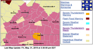
 Via NWS : A Severe Thunderstorm Watch as of 8:95 PM now canceled in South Central Virginia. Click on image above for the latest updates from NWS.
8:05 PM : Severe Thunderstorm Watch is cancelled details here.
URGENT - IMMEDIATE BROADCAST REQUESTED Severe Thunderstorm Watch Number 300 NWS Storm Prediction Center Norman OK 130 PM EDT Fri May 31 2019 The NWS Storm Prediction Center has issued a * Severe Thunderstorm Watch for portions of North Carolina Southern Virginia Far southern West Virginia Coastal Waters * Effective this Friday afternoon and evening from 130 PM until 1100 PM EDT. * Primary threats include... Scattered damaging wind gusts to 70 mph likely Scattered large hail and isolated very large hail events to 2 inches in diameter possible SUMMARY...Episodic severe storms are expected into this evening with several cells and multiple clusters spreading east. Damaging winds are the primary threat, but large hail is possible as well. The severe thunderstorm watch area is approximately along and 105 statute miles north and south of a line from 35 miles south southwest of Dublin VA to 55 miles east northeast of New Bern NC. For a complete depiction of the watch see the associated watch outline update (WOUS64 KWNS WOU0). PRECAUTIONARY/PREPAREDNESS ACTIONS... REMEMBER...A Severe Thunderstorm Watch means conditions are favorable for severe thunderstorms in and close to the watch area. Persons in these areas should be on the lookout for threatening weather conditions and listen for later statements and possible warnings. Severe thunderstorms can and occasionally do produce tornadoes.
SEVERE THUNDERSTORM WATCH OUTLINE UPDATE FOR WS 300 NWS STORM PREDICTION CENTER NORMAN OK 130 PM EDT FRI MAY 31 2019 SEVERE THUNDERSTORM WATCH 300 IS IN EFFECT UNTIL 1100 PM EDT FOR THE FOLLOWING LOCATIONS VA . VIRGINIA COUNTIES INCLUDED ARE ALLEGHANY AMELIA AMHERST APPOMATTOX BATH BEDFORD BLAND BOTETOURT BRUNSWICK BUCKINGHAM CAMPBELL CARROLL CHARLOTTE CRAIG CUMBERLAND DINWIDDIE FLOYD FRANKLIN GILES GRAYSON GREENSVILLE HALIFAX HENRY ISLE OF WIGHT LUNENBURG MECKLENBURG MONTGOMERY NOTTOWAY PATRICK PITTSYLVANIA PRINCE EDWARD PRINCE GEORGE PULASKI ROANOKE ROCKBRIDGE SMYTH SOUTHAMPTON SURRY SUSSEX TAZEWELL WYTHE VIRGINIA INDEPENDENT CITIES INCLUDED ARE BUENA VISTA CHESAPEAKE COVINGTON DANVILLE EMPORIA FRANKLIN GALAX HOPEWELL LEXINGTON LYNCHBURG MARTINSVILLE NORFOLK PETERSBURG PORTSMOUTH RADFORD ROANOKE SALEM SUFFOLK VIRGINIA BEACH
