
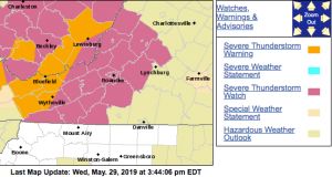
 Via NWS : A Severe Thunderstorm Watch is in effect for the highlighted counties until 8 PM this evening. Click on graphic above for absolute latest updates from NWS
HE NATIONAL WEATHER SERVICE HAS CANCELLED SEVERE THUNDERSTORM
WATCH 294 FOR THE FOLLOWING AREAS
IN VIRGINIA THIS CANCELS 16 COUNTIES
IN CENTRAL VIRGINIA
AMHERST
IN SOUTHWEST VIRGINIA
CARROLL CITY OF GALAX CITY OF RADFORD
FLOYD GRAYSON MONTGOMERY
PULASKI WYTHE
IN WEST CENTRAL VIRGINIA
BOTETOURT CITY OF BUENA VISTA CITY OF LEXINGTON
CITY OF ROANOKE CITY OF SALEM ROANOKE
ROCKBRIDGE
SEVERE THUNDERSTORM WATCH OUTLINE UPDATE FOR WS 294
NWS STORM PREDICTION CENTER NORMAN OK
340 PM EDT WED MAY 29 2019
SEVERE THUNDERSTORM WATCH 294 IS IN EFFECT UNTIL 800 PM EDT
FOR THE FOLLOWING LOCATIONS
VAC005-009-017-019-021-023-035-045-063-067-071-077-121-141-155-
161-163-173-185-197-530-580-640-678-750-770-775-300000-
/O.NEW.KWNS.SV.A.0294.190529T1940Z-190530T0000Z/
VA
. VIRGINIA COUNTIES INCLUDED ARE
ALLEGHANY AMHERST BATH
BEDFORD BLAND BOTETOURT
CARROLL CRAIG FLOYD
FRANKLIN GILES GRAYSON
MONTGOMERY PATRICK PULASKI
ROANOKE ROCKBRIDGE SMYTH
TAZEWELL WYTHE
VIRGINIA INDEPENDENT CITIES INCLUDED ARE
BUENA VISTA COVINGTON GALAX
LEXINGTON RADFORD ROANOKE
SALEM
URGENT – IMMEDIATE BROADCAST REQUESTED
Severe Thunderstorm Watch Number 294
NWS Storm Prediction Center Norman OK
340 PM EDT Wed May 29 2019
The NWS Storm Prediction Center has issued a
* Severe Thunderstorm Watch for portions of
Western Virginia
Southeastern West Virginia
* Effective this Wednesday afternoon and evening from 340 PM
until 800 PM EDT.
* Primary threats include…
Scattered damaging wind gusts to 70 mph possible
Isolated large hail events to 1 inch in diameter possible
SUMMARY…A cluster of storms across far western Virginia and
southern West Virginia will continue moving east-southeastward the
remainder of this afternoon into this evening. The threat for
damaging winds and isolated large hail could persist for the next
few hours, before the storms weaken.
The severe thunderstorm watch area is approximately along and 60
statute miles east and west of a line from 30 miles east northeast
of White Sulphur Springs WV to 50 miles south southwest of Bluefield
WV. For a complete depiction of the watch see the associated watch
outline update (WOUS64 KWNS WOU4).
PRECAUTIONARY/PREPAREDNESS ACTIONS…
REMEMBER…A Severe Thunderstorm Watch means conditions are
favorable for severe thunderstorms in and close to the watch area.
Persons in these areas should be on the lookout for threatening
weather conditions and listen for later statements and possible
warnings. Severe thunderstorms can and occasionally do produce
tornadoes.
