
Central Virginia Blue Ridge
UPDATED: 10 PM 4.19.19 : All severe weather has ended across the area and all watches and warnings in the immediate area have been canceled.
Have a great weekend!
Tommy
Ok folks here’s the sort of quick and dirty. As time is going to be short with me as the day progresses. I personally have never seen the storm prediction center issue the moderate risk category for severe weather in our area. Back in the mid south where I spent the lion’s share of my weather stint, it was fairly common. But not here. It’s happened here. Yes. I just don’t remember it. It’s not common for the blue ridge area.
This means the chance for seeing damaging severe weather is high. 4 out of 5 on their scale. The biggest threat by far is damaging winds. I’ve read some estimates of 65 knots (that’s around 75 MPH) for any storms that reach those levels.
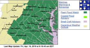
Just be prepared in case this all comes together. The greater risk is still south of Nelson. But anywhere in these areas you see shaded in the top image, severe weather is probable.
I’m on the air this afternoon and evening along with my other colleagues David Reese and Jack Durkin at CBS19 Weather Authority in Charlottesville. I’ll update my other pages a much as possible but follow me there as well later if this all gets cranking. Should it happen. It’s going to be a very busy afternoon & evening!!
Tommy
