
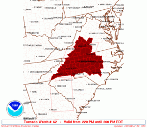
 From Storm Prediction Center : A tornado watch is in effect until 8PM Sunday evening for the areas highlighted in red. Amherst-Appomattox-Buckingham are three of several other nearby counties included in the watch. Click image above for the absolute latest updated info from SPC.
 Tornado Watch – CANCELED
TORNADO WATCH 62…PREVIOUSLY IN EFFECT UNTIL 8 PM EDT THIS
EVENING…IS NOW IN EFFECT UNTIL 10 PM EDT THIS EVENING FOR THE
FOLLOWING AREAS
IN NORTH CAROLINA THIS WATCH INCLUDES 7 COUNTIES
IN NORTH CENTRAL NORTH CAROLINA
CASWELL ROCKINGHAM STOKES
SURRY
IN NORTHWEST NORTH CAROLINA
ALLEGHANY NC WILKES YADKIN
IN VIRGINIA THIS WATCH INCLUDES 23 COUNTIES
IN CENTRAL VIRGINIA
AMHERST APPOMATTOX BUCKINGHAM
CAMPBELL CITY OF LYNCHBURG
IN SOUTH CENTRAL VIRGINIA
BEDFORD CHARLOTTE CITY OF DANVILLE
CITY OF MARTINSVILLE HALIFAX HENRY
PITTSYLVANIA
IN SOUTHWEST VIRGINIA
CARROLL FLOYD PATRICK
IN WEST CENTRAL VIRGINIA
BOTETOURT CITY OF BUENA VISTA CITY OF LEXINGTON
CITY OF ROANOKE CITY OF SALEM FRANKLIN
ROANOKE ROCKBRIDGE
URGENT - IMMEDIATE BROADCAST REQUESTED Tornado Watch Number 62 NWS Storm Prediction Center Norman OK 220 PM EDT Sun Apr 14 2019 The NWS Storm Prediction Center has issued a * Tornado Watch for portions of North Carolina Western Virginia * Effective this Sunday afternoon and evening from 220 PM until 800 PM EDT. * Primary threats include... A couple tornadoes possible Isolated damaging wind gusts to 65 mph possible SUMMARY...Multiple clusters and rounds of thunderstorms are expected into early evening. A couple tornadoes and locally damaging winds are the primary hazards. The tornado watch area is approximately along and 90 statute miles east and west of a line from 25 miles south southwest of Charlotte NC to 50 miles north of Danville VA. For a complete depiction of the watch see the associated watch outline update (WOUS64 KWNS WOU2). PRECAUTIONARY/PREPAREDNESS ACTIONS... REMEMBER...A Tornado Watch means conditions are favorable for tornadoes and severe thunderstorms in and close to the watch area. Persons in these areas should be on the lookout for threatening weather conditions and listen for later statements and possible warnings.
