
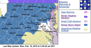
The most recent post with update watch and warning information can be found by clicking here.
WINTER STORM WATCH IN EFFECT FROM TUESDAY EVENING THROUGH WEDNESDAY EVENING
URGENT – WINTER WEATHER MESSAGE
National Weather Service Baltimore MD/Washington DC
338 AM EST Mon Feb 18 2019
District of Columbia-Washington-Frederick MD-Carroll-
Northern Baltimore-Southern Baltimore-Prince Georges-Anne Arundel-
Extreme Western Allegany-Central and Eastern Allegany-
Northwest Montgomery-Central and Southeast Montgomery-
Northwest Howard-Central and Southeast Howard-Northwest Harford-
Southeast Harford-Augusta-Rockingham-Shenandoah-Frederick VA-Page-
Warren-Clarke-Nelson-Albemarle-Greene-Madison-Rappahannock-Orange-
Culpeper-Prince William/Manassas/Manassas Park-Fairfax-
Arlington/Falls Church/Alexandria-Stafford-Spotsylvania-
Northern Fauquier-Southern Fauquier-Western Highland-
Eastern Highland-Western Loudoun-Eastern Loudoun-
Northern Virginia Blue Ridge-Central Virginia Blue Ridge–
Hampshire-Morgan-Berkeley-Jefferson-Hardy-Western Grant-
Eastern Grant-Western Mineral-Eastern Mineral-Western Pendleton-
Eastern Pendleton-
338 AM EST Mon Feb 18 2019
…WINTER STORM WATCH IN EFFECT FROM TUESDAY EVENING THROUGH
WEDNESDAY EVENING…
* WHAT…Heavy snow, mixing with and eventually changing to sleet
and then freezing rain. Snow accumulations of 5 or more inches
and ice accumulations of a quarter-inch or greater are possible.
* WHERE…The District of Columbia, Maryland east of the
Appalachians and west of the Chesapeake Bay, central and
northern Virginia, and the eastern West Virginia panhandle.
* WHEN…From Tuesday evening through Wednesday evening.
* ADDITIONAL DETAILS…Travel could be very difficult. The
hazardous conditions could impact the morning or evening
commute.
PRECAUTIONARY/PREPAREDNESS ACTIONS…
A Winter Storm Watch means there is potential for significant
snow, sleet or ice accumulations that may impact travel. Continue
to monitor the latest forecasts.
URGENT – WINTER WEATHER MESSAGE
National Weather Service Blacksburg VA
328 AM EST Mon Feb 18 2019
…Winter weather expected from Tuesday afternoon into Wednesday
afternoon…
.A strong area of high pressure will shifts east into the
Northeast United States, this will result in cold air wedging
down the Appalachians. As a winter storm lifts northeast across
our region, precipitation will spread north over this shallow dome
of cold air, producing a wintery mixture of snow, sleet and
freezing rain across our region. The storm is still evolving and
the amounts and precipitation types will likely change over time.
Ashe-Alleghany NC-Surry-Watauga-Wilkes-Tazewell-Smyth-Bland-Giles-
Wythe-Pulaski-Montgomery-Grayson-Carroll-Floyd-Craig-Alleghany VA-
Bath-Roanoke-Botetourt-Rockbridge-Patrick-Franklin-Bedford-
Amherst-Henry-Pittsylvania-Campbell-Appomattox-Buckingham-Mercer-
Summers-Monroe-Eastern Greenbrier-Western Greenbrier-
Including the cities of West Jefferson, Sparta, Dobson, Boone,
Wilkesboro, Tazewell, Marion, Bland, Pearisburg, Wytheville,
Radford, Pulaski, Blacksburg, Independence, Whitetop, Troutdale,
Volney, Galax, Floyd, New Castle, Clifton Forge, Covington,
Hot Springs, Roanoke, Salem, Fincastle, Lexington, Buena Vista,
Stuart, Rocky Mount, Amherst, Martinsville, Danville, Lynchburg,
Appomattox, Bluefield, Hinton, Hix, Union, Lewisburg,
White Sulphur Springs, Quinwood, Duo, and Rainelle
328 AM EST Mon Feb 18 2019
…WINTER STORM WATCH IN EFFECT FROM TUESDAY AFTERNOON THROUGH
WEDNESDAY AFTERNOON…
* WHAT…Heavy mixed precipitation possible. Total snow
accumulations will vary from light amounts in the piedmont to
heavy snows in Southeast West Virginia and Alleghany highlands
of Virginia. The highest amounts of snow will occur in western
Greenbrier where 4 to 8 inches are possible. Ice accumulations
will range from a light glaze to around one quarter of an inch.
* WHERE…Portions of southwest Virginia, northwest North
Carolina and southeast West Virginia.
* WHEN…From Tuesday afternoon through Wednesday afternoon.
* ADDITIONAL DETAILS…Power outages and tree damage are likely
due to the ice. Travel could be nearly impossible. The hazardous
conditions could impact the morning and evening commutes.
PRECAUTIONARY/PREPAREDNESS ACTIONS…
A Winter Storm Watch means there is potential for significant
snow, sleet or ice accumulations that may impact travel. Continue
to monitor the latest forecasts.
