
This watch has been replaced by a winter storm warning for some counties including Nelson & Wintergreen.
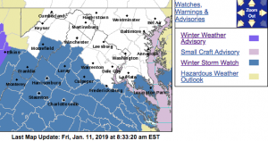
WINTER STORM WATCH
URGENT – WINTER WEATHER MESSAGE
National Weather Service Baltimore MD/Washington DC
337 AM EST Fri Jan 11 2019
MDZ017-VAZ036>040-050-051-056-057-111645-
/O.NEW.KLWX.WS.A.0002.190112T1700Z-190113T1700Z/
St. Marys-Nelson-Albemarle-Greene-Madison-Rappahannock-Orange-
Culpeper-Spotsylvania-King George-
337 AM EST Fri Jan 11 2019
…WINTER STORM WATCH IN EFFECT FROM SATURDAY AFTERNOON THROUGH
SUNDAY MORNING…
* WHAT…Significant snow possible. Snowfall accumulations of 5 or
more inches possible.
* WHERE…Portions of central Virginia, the Virginia Piedmont and
extreme southern Maryland.
* WHEN…From Saturday afternoon through Sunday morning. The
steadiest snow is most likely late Saturday afternoon into
Sunday morning.
* ADDITIONAL DETAILS…Travel may be difficult due to snow covered
and slippery roads.
PRECAUTIONARY/PREPAREDNESS ACTIONS…
A Winter Storm Watch means there is potential for significant
snow, sleet or ice accumulations that may impact travel. Continue
to monitor the latest forecasts.
URGENT – WINTER WEATHER MESSAGE
National Weather Service Baltimore MD/Washington DC
337 AM EST Fri Jan 11 2019
VAZ025>027-029-030-503-504-507-508-WVZ055-505-506-111645-
/O.NEW.KLWX.WS.A.0002.190112T1500Z-190113T1700Z/
Augusta-Rockingham-Shenandoah-Page-Warren-Western Highland-
Eastern Highland-Northern Virginia Blue Ridge-
Central Virginia Blue Ridge-Hardy-Western Pendleton-
Eastern Pendleton-
337 AM EST Fri Jan 11 2019
…WINTER STORM WATCH IN EFFECT FROM SATURDAY MORNING THROUGH
SUNDAY MORNING…
* WHAT…Significant snow possible. Snowfall accumulations of 5 or
more inches possible.
* WHERE…Portions of the Potomac Highlands in eastern West
Virginia and Virginia as well as the central Shenandoah Valley.
* WHEN…From Saturday morning through Sunday morning. The
steadiest snow is most likely Saturday afternoon through Sunday
morning.
* ADDITIONAL DETAILS…Travel may be difficult due to snow covered
and slippery roads.
PRECAUTIONARY/PREPAREDNESS ACTIONS…
A Winter Storm Watch means there is potential for significant
snow, sleet or ice accumulations that may impact travel. Continue
to monitor the latest forecasts.
URGENT – WINTER WEATHER MESSAGE
National Weather Service Blacksburg VA
406 AM EST Fri Jan 11 2019
…Snow to wintry mix expected this weekend…
.A storm system moving out of the mid-Mississippi Valley will
affect a large part of the area with wintry weather, beginning
Saturday and lasting into early Sunday night. Areas north of Route
460 are expected to see predominantly snow, with snow mixing with
sleet and freezing rain further south. Greatest impact is expected
Saturday night into Sunday morning. Wintry weather begins to taper
off by Sunday evening.
VAZ013-014-017-022-034-035-045>047-112100-
/O.NEW.KRNK.WS.A.0002.190112T1800Z-190114T0000Z/
Pulaski-Montgomery-Floyd-Roanoke-Bedford-Amherst-Campbell-
Appomattox-Buckingham-
Including the cities of Radford, Pulaski, Blacksburg, Floyd,
Roanoke, Salem, Amherst, Lynchburg, and Appomattox
406 AM EST Fri Jan 11 2019
…WINTER STORM WATCH IN EFFECT FROM SATURDAY AFTERNOON THROUGH
SUNDAY EVENING…
* WHAT…Heavy snow with sleet possible. Total combined snow and
sleet accumulations of 4 to 6 inches possible.
* WHERE…Much of the New River Valley, Roanoke County eastward
to the central Virginia Piedmont.
* WHEN…From Saturday afternoon through Sunday evening.
* ADDITIONAL DETAILS…Plan on slippery and snow covered road
conditions especially Saturday night into Sunday.
PRECAUTIONARY/PREPAREDNESS ACTIONS…
A Winter Storm Watch means there is potential for significant
snow, sleet or ice accumulations that may impact travel. Continue
to monitor the latest forecasts.
&&
$$
URGENT – WINTER WEATHER MESSAGE
National Weather Service Blacksburg VA
406 AM EST Fri Jan 11 2019
…Snow to wintry mix expected this weekend…
.A storm system moving out of the mid-Mississippi Valley will
affect a large part of the area with wintry weather, beginning
Saturday and lasting into early Sunday night. Areas north of Route
460 are expected to see predominantly snow, with snow mixing with
sleet and freezing rain further south. Greatest impact is expected
Saturday night into Sunday morning. Wintry weather begins to taper
off by Sunday evening.
VAZ011-018>020-023-024-WVZ042>044-507-508-112100-
/O.NEW.KRNK.WS.A.0002.190112T1500Z-190114T0000Z/
Giles-Craig-Alleghany VA-Bath-Botetourt-Rockbridge-Mercer-Summers-
Monroe-Eastern Greenbrier-Western Greenbrier-
Including the cities of Pearisburg, New Castle, Clifton Forge,
Covington, Hot Springs, Fincastle, Lexington, Buena Vista,
Bluefield, Hinton, Hix, Union, Lewisburg, White Sulphur Springs,
Quinwood, Duo, and Rainelle
406 AM EST Fri Jan 11 2019
…WINTER STORM WATCH IN EFFECT FROM SATURDAY MORNING THROUGH
SUNDAY EVENING…
* WHAT…Heavy snow possible. Total snow accumulations of 4 to 6
inches, with isolated amounts up to 8 inches possible.
* WHERE…The Alleghany Highlands, southern Shenandoah Valley and
much of southeastern West Virginia.
* WHEN…From Saturday morning through Sunday evening.
* ADDITIONAL DETAILS…Plan on slippery and snow covered road
conditions especially Saturday night into Sunday.
PRECAUTIONARY/PREPAREDNESS ACTIONS…
A Winter Storm Watch means there is potential for significant
snow, sleet or ice accumulations that may impact travel. Continue
to monitor the latest forecasts.
