
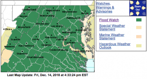
FLOOD WATCH NOW IN EFFECT FROM SATURDAY MORNING THROUGH LATE SATURDAY NIGHT
Flood Watch
National Weather Service Baltimore MD/Washington DC
239 PM EST Fri Dec 14 2018
Charles-St. Marys-Augusta-Nelson-Albemarle-Greene-Orange-Stafford-
Spotsylvania-King George-Central Virginia Blue Ridge-
Including the cities of St. Charles, Waldorf, Lexington Park,
California, Staunton, Waynesboro, Stuarts Draft, Lovingston,
Charlottesville, Stanardsville, Orange, Gordonsville, Falmouth,
Fredericksburg, Dahlgren, and Wintergreen
239 PM EST Fri Dec 14 2018
…FLOOD WATCH NOW IN EFFECT FROM SATURDAY MORNING THROUGH LATE
SATURDAY NIGHT…
The Flood Watch is now in effect for
* Portions of southern Maryland and Virginia, including the
following areas, in southern Maryland, Charles and St. Marys.
In Virginia, Albemarle, Augusta, Central Virginia Blue Ridge,
Greene, King George, Nelson, Orange, Spotsylvania, and
Stafford.
* From Saturday morning through late Saturday night
* Moderate rainfall is expected with locally heavy rain possible.
Rainfall amounts of 1.5 to 2.5 inches are most likely with
locally higher amounts of 3 to 4 inches possible. Runoff from
the rainfall combined with melted snow may cause creeks and
streams to rise out of their banks as well as the potential for
flooding in urban areas.
PRECAUTIONARY/PREPAREDNESS ACTIONS…
A Flood Watch means there is a potential for flooding based on
current forecasts.
You should monitor later forecasts and be alert for possible
Flood Warnings. Those living in areas prone to flooding should be
prepared to take action should flooding develop.
Flood Watch
National Weather Service Baltimore MD/Washington DC
239 PM EST Fri Dec 14 2018
District of Columbia-Washington-Frederick MD-Carroll-
Northern Baltimore-Southern Baltimore-Prince Georges-Anne Arundel-
Calvert-Northwest Montgomery-Central and Southeast Montgomery-
Northwest Howard-Central and Southeast Howard-Northwest Harford-
Southeast Harford-Rockingham-Shenandoah-Frederick VA-Page-Warren-
Clarke-Madison-Rappahannock-Culpeper-
Prince William/Manassas/Manassas Park-Fairfax-
Arlington/Falls Church/Alexandria-Northern Fauquier-
Southern Fauquier-Western Loudoun-Eastern Loudoun-
Northern Virginia Blue Ridge-Hampshire-Morgan-Berkeley-Jefferson-
Hardy-
Including the cities of Washington, Hagerstown, Frederick,
Ballenger Creek, Eldersburg, Westminster, Reisterstown,
Cockeysville, Baltimore, Bowie, Suitland-Silver Hill, Clinton,
College Park, Greenbelt, Laurel, Camp Springs, Glen Burnie,
Annapolis, Severn, South Gate, Severna Park, Arnold, Odenton,
Chesapeake Beach, Huntingtown, Dunkirk, North Beach, Lusby,
Prince Frederick, Germantown, Damascus, Bethesda, Rockville,
Gaithersburg, Silver Spring, Lisbon, Columbia, Ellicott City,
Jarrettsville, Aberdeen, Harrisonburg, Strasburg, Woodstock,
Mount Jackson, New Market, Winchester, Luray, Shenandoah,
Stanley, Front Royal, Berryville, Madison, Culpeper, Dale City,
Manassas, Woodbridge, Lake Ridge, Montclair, Reston, Herndon,
Annandale, Centreville, Chantilly, McLean, Franconia, Arlington,
Alexandria, Falls Church, Warrenton, Turnbull, Purcellville,
Leesburg, Ashburn, Sterling, Big Meadows, Romney, Paw Paw,
Martinsburg, Charles Town, Shepherdstown, and Moorefield
239 PM EST Fri Dec 14 2018
…FLOOD WATCH NOW IN EFFECT FROM SATURDAY AFTERNOON THROUGH LATE
SATURDAY NIGHT…
The Flood Watch is now in effect for
* Portions of Maryland, The District of Columbia, Virginia, and
West Virginia, including the following areas, in Maryland,
Anne Arundel, Calvert, Carroll, Central and Southeast Howard,
Central and Southeast Montgomery, Frederick MD, Northern
Baltimore, Northwest Harford, Northwest Howard, Northwest
Montgomery, Prince Georges, Southeast Harford, Southern
Baltimore, and Washington. The District of Columbia. In
Virginia, Arlington/Falls Church/Alexandria, Clarke, Culpeper,
Eastern Loudoun, Fairfax, Frederick VA, Madison, Northern
Fauquier, Northern Virginia Blue Ridge, Page, Prince
William/Manassas/Manassas Park, Rappahannock, Rockingham,
Shenandoah, Southern Fauquier, Warren, and Western Loudoun. In
West Virginia, Berkeley, Hampshire, Hardy, Jefferson, and
Morgan.
* From Saturday afternoon through late Saturday night
* Moderate rainfall is expected with locally heavy rain possible.
Rainfall amounts around 1.5 to 2.5 inches are most likely with
locally higher amounts around 3 to 4 inches possible. Runoff
from the rainfall may cause creeks and streams to rise out of
their banks as well as the potential for flooding in urban
areas.
PRECAUTIONARY/PREPAREDNESS ACTIONS…
A Flood Watch means there is a potential for flooding based on
current forecasts.
You should monitor later forecasts and be alert for possible
Flood Warnings. Those living in areas prone to flooding should be
prepared to take action should flooding develop.
Flood Watch
National Weather Service Blacksburg VA
116 PM EST Fri Dec 14 2018
…FLOOD WATCH DUE TO RAINFALL AND SNOW MELT…
.Low pressure tracks from Texas to Alabama to the Mid Atlantic
region today into Saturday. Rainfall will overspread a warm front
ahead of this system this afternoon into early Saturday before
tapering off to showers in the afternoon. Rainfall amounts of 1 to
2 inches, on top of several inches of snow expected to melt, will
bring the potential for flooding especially in urban areas as
well as streams and rivers.
Ashe-Alleghany NC-Surry-Stokes-Rockingham-Caswell-Watauga-Wilkes-
Yadkin-Wythe-Pulaski-Montgomery-Grayson-Carroll-Floyd-Roanoke-
Botetourt-Rockbridge-Patrick-Franklin-Bedford-Amherst-Henry-
Pittsylvania-Campbell-Appomattox-Buckingham-Halifax-Charlotte-
Including the cities of West Jefferson, Sparta, Dobson, Danbury,
Eden, Yanceyville, Boone, Wilkesboro, Yadkinville, Wytheville,
Radford, Pulaski, Blacksburg, Independence, Whitetop, Troutdale,
Volney, Galax, Floyd, Roanoke, Salem, Fincastle, Lexington,
Buena Vista, Stuart, Rocky Mount, Bedford, Amherst, Martinsville,
Danville, Lynchburg, Appomattox, South Boston, and Keysville
116 PM EST Fri Dec 14 2018
…FLOOD WATCH REMAINS IN EFFECT THROUGH SATURDAY AFTERNOON…
The Flood Watch continues for
* Portions of North Carolina and Virginia, including the
following areas, in North Carolina, Alleghany NC, Ashe,
Caswell, Rockingham, Stokes, Surry, Watauga, Wilkes, and
Yadkin. In Virginia, Amherst, Appomattox, Bedford, Botetourt,
Buckingham, Campbell, Carroll, Charlotte, Floyd, Franklin,
Grayson, Halifax, Henry, Montgomery, Patrick, Pittsylvania,
Pulaski, Roanoke, Rockbridge, and Wythe.
* Through Saturday afternoon
* 1 to 1.5 inches of rainfall will occur on top of several
inches of snow cover. Runoff from this plus melting snow may
cause flooding along streams, creeks and eventually rivers, as
well as urban areas.
* Those living along creeks and streams and larger rivers need to
monitor them today into the weekend. Main stem rivers,
especially the Dan and lower Roanoke Rivers may flood this
weekend.
PRECAUTIONARY/PREPAREDNESS ACTIONS…
A Flood Watch means there is a potential for flooding based on
current forecasts.
You should monitor later forecasts and be alert for possible
Flood Warnings. Those living in areas prone to flooding should be
prepared to take action should flooding develop.
