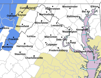
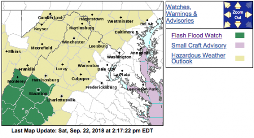
 Click on the above image for the latest updates from NWS
FLASH FLOOD WATCH IS CANCELLED
Augusta-Nelson-Western Highland-Eastern Highland-
Central Virginia Blue Ridge-
Including the cities of Staunton, Waynesboro, Stuarts Draft,
Lovingston, Hightown, Monterey, and Wintergreen
537 PM EDT Sat Sep 22 2018
…FLASH FLOOD WATCH IS CANCELLED…
The Flash Flood Watch for portions of central Virginia and
western Virginia has been cancelled. Heavy rainfall from showers
and a few thunderstorms has developed and will remain south of the
area this evening.
Flood Watch
National Weather Service Baltimore MD/Washington DC
210 PM EDT Sat Sep 22 2018
VAZ025-036-503-504-508-230215-
/O.NEW.KLWX.FF.A.0026.180922T1900Z-180923T0400Z/
/00000.0.ER.000000T0000Z.000000T0000Z.000000T0000Z.OO/
Augusta-Nelson-Western Highland-Eastern Highland-
Central Virginia Blue Ridge-
Including the cities of Staunton, Waynesboro, Stuarts Draft,
Lovingston, Hightown, Monterey, and Wintergreen
210 PM EDT Sat Sep 22 2018
…FLASH FLOOD WATCH IN EFFECT UNTIL MIDNIGHT EDT TONIGHT…
The National Weather Service in Sterling Virginia has issued a
* Flash Flood Watch for portions of central Virginia and western
Virginia, including the following areas, in central Virginia,
Central Virginia Blue Ridge and Nelson. In western Virginia,
Augusta, Eastern Highland, and Western Highland.
* Until midnight EDT tonight
* Showers and a few thunderstorms will be slow moving to the north
side of a stationary front that lies across southern Virginia.
These showers and thunderstorms will bring moderate to heavy
rainfall to areas that are already saturated from recent
rainfall during the past couple of weeks. This heavy rainfall
could result in flash flooding.
* Urban areas, locations along small streams and creeks, and poor
drainage areas are most vulnerable to flash flooding.
PRECAUTIONARY/PREPAREDNESS ACTIONS…
A Flash Flood Watch means that conditions may develop that lead
to flash flooding. Flash flooding is a very dangerous situation.
You should monitor later forecasts and be prepared to take action
should Flash Flood Warnings be issued.
&&
$$
Flood Watch
National Weather Service Blacksburg VA
136 PM EDT Sat Sep 22 2018
…Very heavy rain possible this afternoon and evening…
.Scattered to numerous thunderstorms will develop this afternoon
ahead of a cold front.
VAZ010>020-022>024-032>035-043-230400-
/O.NEW.KRNK.FF.A.0014.180922T1900Z-180923T0400Z/
/00000.0.ER.000000T0000Z.000000T0000Z.000000T0000Z.OO/
Bland-Giles-Wythe-Pulaski-Montgomery-Grayson-Carroll-Floyd-Craig-
Alleghany VA-Bath-Roanoke-Botetourt-Rockbridge-Patrick-Franklin-
Bedford-Amherst-Henry-
Including the cities of Bland, Pearisburg, Wytheville, Radford,
Pulaski, Blacksburg, Independence, Whitetop, Troutdale, Volney,
Galax, Floyd, New Castle, Clifton Forge, Covington, Hot Springs,
Roanoke, Salem, Fincastle, Lexington, Buena Vista, Stuart,
Rocky Mount, Bedford, Amherst, and Martinsville
136 PM EDT Sat Sep 22 2018
…FLASH FLOOD WATCH IN EFFECT UNTIL MIDNIGHT EDT TONIGHT…
The National Weather Service in Blacksburg has issued a
* Flash Flood Watch for portions of central Virginia, south
central Virginia, southwest Virginia, and west central
Virginia, including the following areas, in central Virginia,
Amherst. In south central Virginia, Bedford and Henry. In
southwest Virginia, Bland, Carroll, Craig, Floyd, Giles,
Grayson, Montgomery, Patrick, Pulaski, and Wythe. In west
central Virginia, Alleghany VA, Bath, Botetourt, Franklin,
Roanoke, and Rockbridge.
* Until midnight EDT tonight
* Scattered to numerous thunderstorms may produce heavy rain this
afternoon and evening. Rainfall rates in some of the slower
moving stronger storms will approach 2 inches per hour. 1 to 2
inches of rain are expected along the Blue Ridge and the
foothills of Virginia into the New River Valley. Localized
rainfall amount may reach 3 to 5 inches.
* Poor drainage areas and urban areas may flood. Small streams and
creeks may overflow their banks, potentially flooding nearby
roads.
PRECAUTIONARY/PREPAREDNESS ACTIONS…
A Flash Flood Watch means that conditions may develop that lead
to flash flooding. Flash flooding is a VERY DANGEROUS SITUATION.
Remember…TURN AROUND…DON`T DROWN!
You should monitor later forecasts and be prepared to take action
should Flash Flood Warnings be issued.


