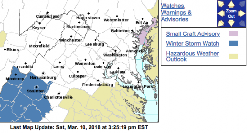
This watch has now been upgraded to a warning. Click for details.
WINTER STORM WATCH
URGENT – WINTER WEATHER MESSAGE
National Weather Service Baltimore MD/Washington DC
311 PM EST Sat Mar 10 2018
Augusta-Nelson-Western Highland-Eastern Highland-
Central Virginia Blue Ridge-
311 PM EST Sat Mar 10 2018
…WINTER STORM WATCH IN EFFECT FROM SUNDAY EVENING THROUGH
MONDAY MORNING…
* WHAT…Significant snow possible with the potential for around 5
inches of accumulation.
* WHERE…Augusta, Nelson, Highland, and Central Virginia Blue
Ridge.
* WHEN…From late Sunday evening through Monday morning.
* ADDITIONAL DETAILS…Plan on difficult travel conditions due to
snow covered and slippery roads, including during the morning
commute on Monday. Significant reductions in visibility are
possible.
PRECAUTIONARY/PREPAREDNESS ACTIONS…
A Winter Storm Watch means there is potential for significant
snow accumulations that may impact travel. Continue to monitor
the latest forecasts.
URGENT – WINTER WEATHER MESSAGE
National Weather Service Blacksburg VA
327 PM EST Sat Mar 10 2018
A complex storm system will develop over the southeastern US on
Sunday, before moving toward the North Carolina coast early
Monday. This may bring moderate to heavy snow to the region,
especially west of the Blue Ridge, Sunday night through Monday
morning.
Alleghany VA-Bath-Botetourt-Rockbridge-Patrick-Franklin-Bedford-
Amherst-Eastern Greenbrier-Western Greenbrier-
Including the cities of Clifton Forge, Covington, Hot Springs,
Fincastle, Lexington, Buena Vista, Stuart, Rocky Mount, Bedford,
Amherst, Lewisburg, White Sulphur Springs, Quinwood, Duo,
and Rainelle
327 PM EST Sat Mar 10 2018
…WINTER STORM WATCH IN EFFECT FROM SUNDAY EVENING THROUGH
MONDAY AFTERNOON…
* WHAT…Heavy snow possible. Total snow accumulations of 2 to 4
inches, with localized higher amounts along ridgetop.
* WHERE…Portions of central, south central, southwest and west
central Virginia and southeast West Virginia.
* WHEN…From Sunday evening through Monday afternoon.
* ADDITIONAL DETAILS…Plan on difficult travel conditions,
including during the morning commute on Monday. Significant
reductions in visibility are possible.
PRECAUTIONARY/PREPAREDNESS ACTIONS…
A Winter Storm Watch means there is potential for significant
snow, sleet or ice accumulations that may impact travel. Continue
to monitor the latest forecasts.


