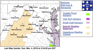
Elevated fire weather conditions this afternoon
Special Weather Statement
National Weather Service Baltimore MD/Washington DC
1138 AM EST Sun Mar 4 2018
Augusta-Rockingham-Shenandoah-Frederick VA-Page-Warren-Clarke-
Nelson-Albemarle-Greene-Madison-Rappahannock-Orange-Culpeper-
Northern Virginia Blue Ridge-Central Virginia Blue Ridge-
Including the cities of Staunton, Waynesboro, Stuarts Draft,
Harrisonburg, Strasburg, Woodstock, Mount Jackson, New Market,
Winchester, Luray, Shenandoah, Stanley, Front Royal, Berryville,
Lovingston, Charlottesville, Stanardsville, Madison, Washington,
Orange, Gordonsville, Culpeper, Big Meadows, and Wintergreen
1138 AM EST Sun Mar 4 2018
…Elevated fire weather conditions this afternoon…
Several days of strong northwest winds have reduced fuel moisture
across the region. This combined with sustained northwest winds
of 15 mph gusting to around 30 mph and minimum relative humidity
values between 25 and 30 percent could contribute to increased
fire spread with any fires that develop.
Special Weather Statement
National Weather Service Blacksburg VA
1221 PM EST Sun Mar 4 2018
Surry-Stokes-Rockingham-Caswell-Wilkes-Yadkin-Roanoke-Botetourt-
Rockbridge-Patrick-Franklin-Bedford-Amherst-Henry-Pittsylvania-
Campbell-Appomattox-Buckingham-Halifax-Charlotte-
Including the cities of Dobson, Danbury, Eden, Yanceyville,
Wilkesboro, Yadkinville, Roanoke, Salem, Fincastle, Lexington,
Buena Vista, Stuart, Rocky Mount, Bedford, Amherst, Martinsville,
Danville, Lynchburg, Appomattox, South Boston, and Keysville
1221 PM EST Sun Mar 4 2018
…Increased Fire Danger for This Afternoon and Evening…
Dry fuels, such as dried leaves, dormant grass, sticks, and twigs,
combined with low relative humidity values in the 20 to 25% range
and north to northeast winds of 15 to 20 mph with occasional
gusts of 25 to 30 mph will result in increased fire danger this
afternoon into the early evening across the Virginia and North
Carolina Piedmont areas, thus mainly east of the Blue Ridge from
Lexington, to Roanoke, to Wilkesboro.
Ignition sources must be extinguished before being discarded.
Outdoor burning is strongly discouraged. Make every effort to
avoid the development and spread of wild fires.


