
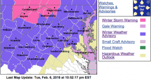
WINTER WEATHER ADVISORY
URGENT – WINTER WEATHER MESSAGE
National Weather Service Baltimore MD/Washington DC
944 PM EST Tue Feb 6 2018
Augusta-Rockingham-Shenandoah-Page-Nelson-Albemarle-Greene-
Madison-Western Highland-Eastern Highland-
Northern Virginia Blue Ridge-Central Virginia Blue Ridge-Hardy-
Western Grant-Eastern Grant-Western Pendleton-Eastern Pendleton-
944 PM EST Tue Feb 6 2018
…WINTER WEATHER ADVISORY REMAINS IN EFFECT FROM 1 AM TO 11 AM
EST WEDNESDAY…
* WHAT…Mixed precipitation expected. Total snow and sleet
accumulations of a coating to an inch and ice accumulations of
around one to two tenths of an inch are expected. The highest
ice accumulations will be west of the Blue Ridge Mountains.
* WHERE…The Potomac Highlands of eastern West Virginia…the
central Shenandoah Valley of Virginia and portions of central
Virginia.
* WHEN…From 1 AM to 11 AM EST Wednesday.
* ADDITIONAL DETAILS…A mix of snow…sleet and freezing rain
will overspread the area between midnight and 3 am overnight.
Precipitation will change to all freezing rain by 7 am before
ending as rain Wednesday afternoon. The ice will result in
difficult travel conditions, including during the morning
commute on Wednesday. Be prepared for reduced visibilities at
times.
PRECAUTIONARY/PREPAREDNESS ACTIONS…
A Winter Weather Advisory means that periods of snow, sleet or
freezing rain will cause travel difficulties. Be prepared for
slippery roads and limited visibilities, and use caution while
driving. The latest road conditions for the state you are calling
from can be obtained by calling 5 1 1.
URGENT – WINTER WEATHER MESSAGE
National Weather Service Blacksburg VA
329 PM EST Tue Feb 6 2018
…Light wintry mix late tonight into early Wednesday…
.Low pressure will advance across the region tonight into early
Wednesday morning. Most of the associated precipitation will fall
as rain. However, the area of West Virginia and Virginia near and
north of the Interstate 64 corridor, east to near Amherst,
Virginia, is expected to be cold enough for a light mix of wintry
precipitation. This could result in slippery travel conditions
from the Greenbrier Valley east into the southern Shenandoah
Valley later tonight and early Wednesday.
Alleghany VA-Bath-Rockbridge-Amherst-Eastern Greenbrier-
Western Greenbrier-
Including the cities of Clifton Forge, Covington, Hot Springs,
Lexington, Buena Vista, Amherst, Lewisburg,
White Sulphur Springs, Quinwood, Duo, and Rainelle
329 PM EST Tue Feb 6 2018
…WINTER WEATHER ADVISORY REMAINS IN EFFECT FROM 10 PM THIS
EVENING TO 10 AM EST WEDNESDAY…
* WHAT…Mixed precipitation expected. Total wet snow and sleet
accumulations of up to one half inch and ice accumulations of
a light glaze are expected.
* WHERE…Portions of central and west central Virginia and
southeast West Virginia.
* WHEN…From 10 PM this evening to 10 AM EST Wednesday.
* ADDITIONAL DETAILS…Plan on slippery road conditions. Be
prepared for reduced visibilities at times.
PRECAUTIONARY/PREPAREDNESS ACTIONS…
A Winter Weather Advisory means that periods of snow, sleet or
freezing rain will cause travel difficulties. Be prepared for
slippery roads and limited visibilities, and use caution while
driving. The latest road conditions for the state you are calling
from can be obtained by calling 5 1 1.
