
Mt. Pleasant
Amherst County, Virginia
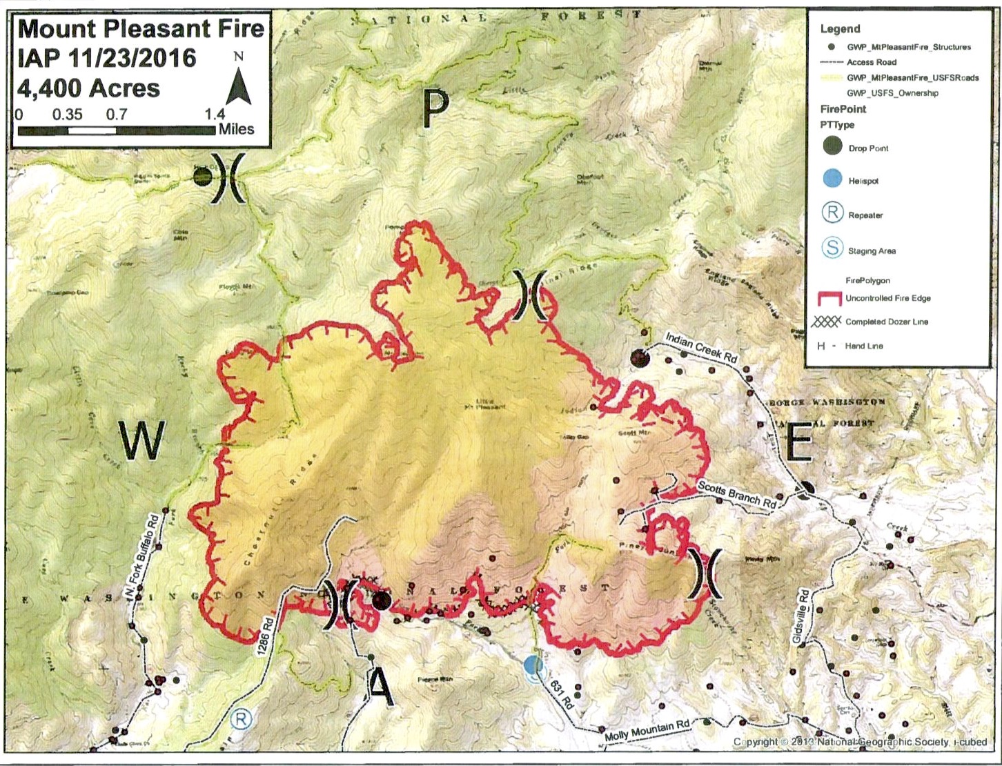
BRL was the first news outlet to break the information last weekend about the massive wildfire that’s been sweeping across the Mt. Pleasant and Thrasher’s Creek areas of Amherst County. As of Wednesday morning 4400 acres has been affected with only 5% contained.
Below is the latest release from the US Forest Service as of Wednesday morning:
Current Status: The Mount Pleasant Fire is located on the George Washington and Jefferson National Forests within the Mount Pleasant National Scenic Area in Amherst County, VA approximately 12 miles northwest of the town of Amherst.
Counties: Amherst County, VA
Estimated Acreage: 4,400 acres
Containment: 5%
Cause and Date Started: The cause of this fire is under investigation. The fire was first reported at approximately 5:30 PM on Saturday, November 19, 2016.
Resources on the Fire: 122 firefighters and support staff including engines, dozers and three aircraft are assigned to this incident with additional resources being mobilized.
Cooperators: Virginia Department of Forestry and Amherst County
Use caution and obey all road and trail closures for your safety.
Road Closures:
North Fork Road (SR 635) closed at Panther Mountain (FR #1286)
Thrasher’s Creek Road (SR) 617 is closed at Molly’s Mountain due to firefighting activities. Local traffic will be permitted
The Mount Pleasant National Scenic Area is temporarily closed due to fire activities. All roads and trails within the Scenic Area are temporarily closed including
Hog Camp Gap Road (FR #48) from Hog Camp Gap to Salt Log Gap
Coon Bridge Road (FR #1167)
Cow Camp Road (FR #520)
Fletcher Mountain Road (FR #507)Trail Closures:
Appalachian National Scenic Trail (FT #1) from Long Mountain Wayside to Salt Log Gap
Old Hotel Trail (FT #515)
Henry Lanum Trail (FT #702)
Mt. Pleasant Trail (FT #704)Plans for Today: Firefighters have begun line construction efforts in addition to structure and property protection. Additional firefighters are being mobilized to assist with the fire suppression operations.
Public meeting is scheduled for this evening at the Central Baptist Church in Arrington at 7 pm.
Fire weather: Lighter winds are forecast for today which should continue to aid in fire containment efforts. Fuel conditions remain dry. There is a slight possibility of showers later this evening.
Other Fire Information: The top priority of fire managers is firefighter and public safety.
Driving visibility may be limited in the fire vicinity due to smoky conditions.
Area residents and visitors may smell smoke overnight and for several days.
There is currently a fire ban on the entire George Washington & Jefferson National Forests.Please take donations to firefighters to the Pedlar Fire Department at 4893 Lexington Turnpike.
We appreciate the public’s concerns for the safety of our firefighters. We are equally concerned for the public’s safety as well. We continue to work with local residents to minimize impacts to their homes and properties. We are requesting that non-residents respect those property owners and avoid the area.Additional Information:
Inciweb: www.inciweb.nwcg.gov
Firewise: www.firewise.org
Near Lovingston
Nelson County, VA
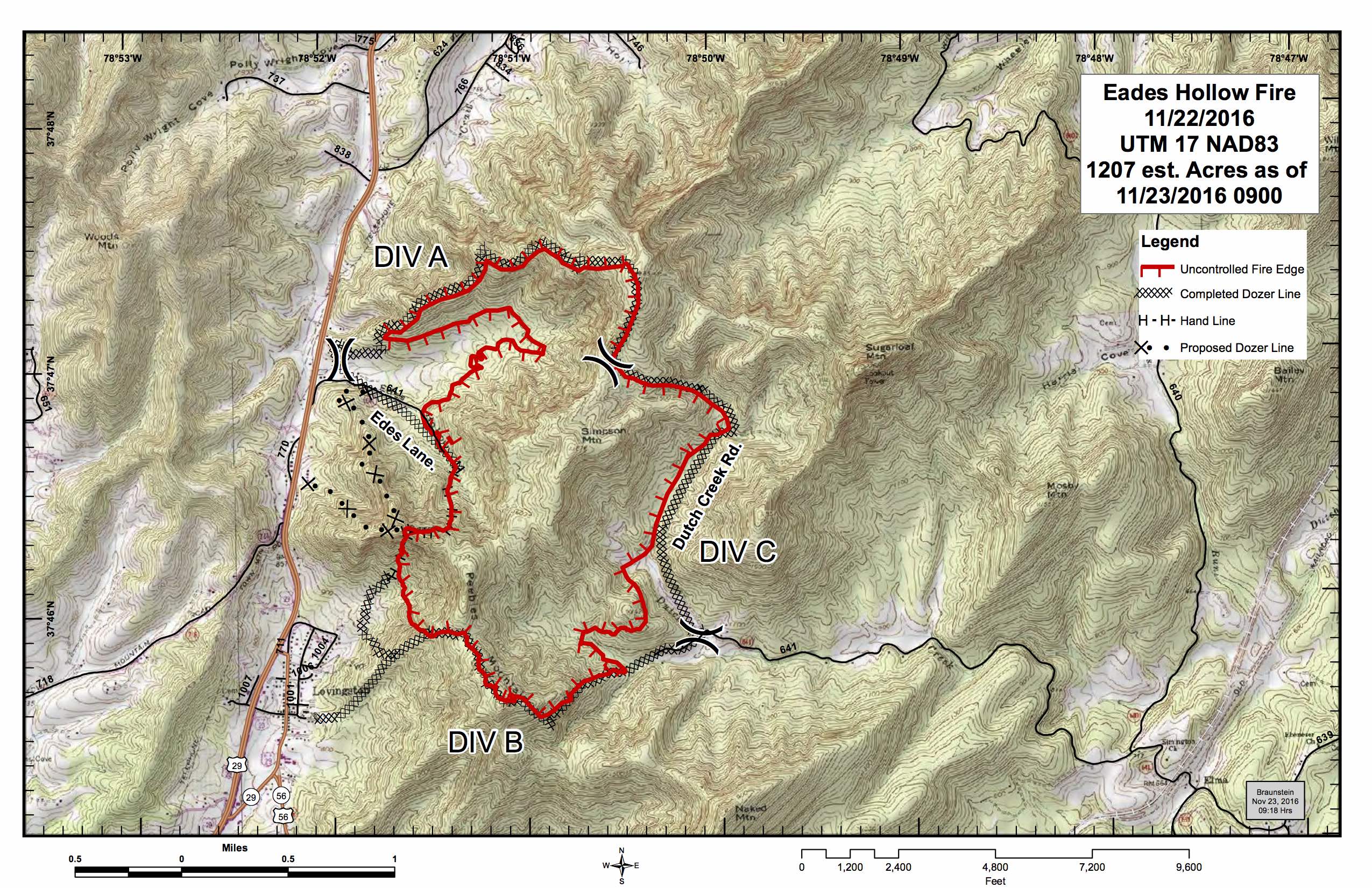
The Eades Hollow fire that’s been underway since last Sunday night is now said to be fully contained (as stated in an email we received Wednesday just before noon – but local authorities say they are being told it’s 70% contained) though smoke continues to rise from that location. The fire near Lovingston has affected 1207 total acres as of Wednesday morning, according to VDOF.
