
Mt. Pleasant
Amherst County, Virginia
BRL first broke the story of the Amherst wildfire over the weekend in this story.
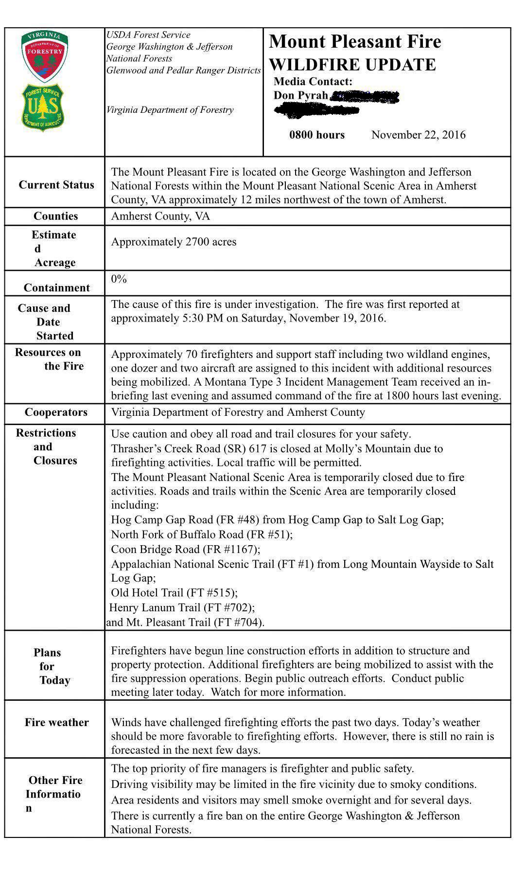
Information released early Tuesday morning on November 22, 2016 reveals the wildfire on Mt. Pleasant in Amherst County has consumed 2700 acres so far.
Additional Update at 11:20 AM to include community meeting Tuesday night. (scroll for that update)
“Wildfire Burning in Mount Pleasant National Scenic Area
Buena Vista, Va. – November 22 – The USDA Forest Service is working with the Virginia
Department of Forestry to contain a wildfire burning on the George Washington National Forest
and private land in and around the Mount Pleasant National Scenic Area in Amherst County. A
Montana Type 3 Incident Management Team arrived last evening and was in briefed for the fire.
The fire is being managed under a unified command between Incident Commanders David
Hamilton and Virginia Department of Forestry Incident Commander Steve Counts.The fire is estimated to be 2700 acres in size. Strong winds and low humidity contributed to the
rapid spread of the fire on Sunday. More favorable conditions are forecast for the next couple of
days which should be beneficial to firefighters struggling with containment efforts.Firefighters continue to build hand and dozer lines to contain the fire. Helicopters are assigned
to the fire and are dropping water within the priority areas as needed. Additional ground
firefighting resources are continuing to arrive at the Incident Command Post which is located at
the Buena Visit Work Station.Thrasher’s Creek Road (SR) 617 is closed at Molly’s Mountain due to firefighting activities.
Local traffic will be permitted.As a result of the fire the Mount Pleasant National Scenic Area has been closed to public entry including the following roads and trails:
Hog Camp Gap Road (FR #48) from Hog Camp Gap to Salt Log Gap
North Fork of Buffalo Road (FR #51)
Coon Bridge Road (FR #1167)
Appalachian Trail (FT #1) from Long Mountain Wayside to Salt Log Gap
Old Hotel Trail (FT #515)
Henry Lanum Trail (FT #702)
Mt. Pleasant Trail (FT #704)
and trailheads associated with these trails.
– more –The fire was discovered on Saturday evening. The cause is under investigation.
There is currently a fire ban on the George Washington & Jefferson National Forests to maintain public safety and protect forest resources during extreme drought.
Building, maintaining, or
using a fire, campfire or stove fire is prohibited on National Forest lands outside of developed recreation areas. For more information regarding the fire ban contact your local Ranger District office or visit the forest website at www.fs.usda.gov/gwj.A public meeting has been scheduled for the evening at the following location at 7 pm.
Central Baptist Church
103 Central Church Lane
Amherst, VA”
Monday evening Amherst County BOS Claudia Tucker siad she felt the fire was well in excess of 2000 acres at that time.
AMHERST WILDFIRE : We just spoke with Amherst BOS Claudia Tucker. She says Mt Pleasant fire "well over 2000 acres, easily."
— BlueRidgeLife (@BlueRidgeLife) November 22, 2016
More updates as we have them.
