Another VERY Cold Wakeup Across The Central Virginia Blue Ridge – Snow Tonight / Late Week?

0
382
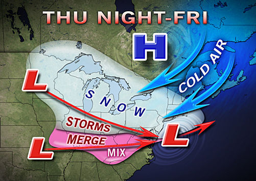
Image ©2013 Accuweather.com : A late week snow storm has the potential to bring a wintry mix to the area as shown in the accuweather.com map above.
Another very cold start to the day! Wednesday morning – January 23, 2013 – temps were once again in the single digits, 4° on the mountain at Wintergreen as seen left above from our station at The Wintergreen Nature Foundation compared to a balmy 11° here at BRLM just north of Nellysford in Nelson County, VA

Central Virginia Blue Ridge
Once again the Central Virginia Blue Ridge awoke in the deep freeze for the second morning in a row. Single digits were common in the higher elevations along the Blue Ridge Parkway & Skyline Drive.

In the valley portions of the area temps dropped to around 10-12° overnight.
Image ©2013 Accuweather.com : A late week snow storm has the potential to bring a wintry mix to the area as shown in the accuweather.com map above.

“Farther east, the area from the northern Shenandoah Valley and Washington, D.C., Philadelphia, Atlantic City, N.J., and Dover, Del., lie in a swath where a few inches of snow could fall. In other words, perhaps enough to shovel and plow.”

Accuweather said in a Wednesday morning post from their site.

Tommy says we may actually get a dusting to an inch of snow overnight Wednesday but the Friday event has the potential to be more significant.

LEAVE A REPLY

Please enter your comment!
Please enter your name here