Nelson County, Virginia
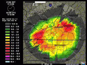
A combination of weather systems continues bringing abundant rainfall to most parts of Virginia. By far, the most serious concerns have been along the Virginia coastline where heavy rains, high winds, and large waves have been coming ashore. The situation is expected to deteriorate even more during the day on Thursday as winds increase.
A State of Emergency was declared by Gov. Tim Kaine late Wednesday in connection with the storm.
Here in and nearby Nelson, lots of rain has fallen as well. As of late Wednesday night, nearly 3″ of rain had fallen up at Devil’s Knob on our NCL-Wintergreen Nature Foundation station. Another concern in the hgiher elevations overnight Wednesday was temps that had fallen very close to freezing. By 10:30 PM the Wintergreen stations was showing a reading of 33.6°.
Here at our office in Greenfield in the Rockfish Valley, our NCL station showed around 1.5″ of rain as of late Wednesday night. Go south just a few miles at our NCL-Devils Backbone location and they had 2.25″ of rain late Wednesday night.
All of the rain and winds are courtesy of what’s left of Hurricane Ida that formed in the gulf and eventually moved up the eastern seaboard. A new low has essentially absorbed Ida but continues to cause tremendous problems up and down the east coast, in particular Virginia and North Carolina. Ida was not predicted to affect our area this much, but the track combined with the new low has created the current situation.
Thursday, expect the rainy weather to continue with gusty northeasterly winds as high as 35 MPH at times here in our area, with some higher gusts up in the mountains.
Conditions are expected to improve by the weekend with warmer temps in the 60’s to near 70° and abundant sunshine.
Listen to the latest weather details over in Tommy’s Weather by clicking here.


It’s not all rain! When I got back to Wintergreen Mountain after a trip last night around 11, the mountain top roads here were snow-covered above the Wintergreen Overlook. Road crews were out working but mother nature was going full steam at that point. My “guess” from the driver’s seat is that around the Wintergarden and Nature Foundation an inch or more had fallen. Heading further west to Laurel Springs Drive, it looked to me more like 2-4 inches (unscientific). On Laurel Springs drive there definitely as enough snow to plow.
Right now (8:10 am), it’s 33 degrees and we are having rain/wintry mix. Fairly thick fog. It doesn’t look like there was much additional accumulation after midnight here.
Hi John,
I figured that you may get more snow because you live at a higher elevation than I do.
Best regards,
Paul
Yea, John I was watching our NCL Weather station over at The Wintergreen Nature Foundation and saw the temps hovering around 32° just before midnight, knew it was going to get interesting overnight! 2-4 inches, WOW! If you get a pic – send it our way! Thanks for the update! Tommy