
Nelson County, Virginia
Severe weather potential increasing over Nelson and Central Virginia. The Storm Prediction Center is eying our area for a Severe Weather Watch to be issued soon. The atmosphere is become increasingly unstable and favorable for severe weather.
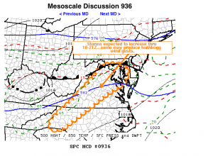
AREAS AFFECTED…VA…MD…WRN NC
CONCERNING…SEVERE POTENTIAL…WATCH LIKELY
VALID 031641Z – 031745Z
STRONG/SEVERE STORMS ARE EXPECTED TO DEVELOP THROUGH THE 18-21Z TIME
FRAME. A WATCH LIKELY WILL BE ISSUED ACROSS MUCH OF REGION SHORTLY.MID/UPPER FORCING FOR CONVECTIVE DEVELOPMENT IS UNCERTAIN IN THE
NEAR TERM. BUT…LOW-LEVEL LAPSE RATES ARE STEEPENING…AND
BOUNDARY LAYER DESTABILIZATION IS WELL UNDERWAY ALONG AND TO THE LEE
OF THE ALLEGHENY AND BLUE RIDGE MOUNTAINS. LATEST RUC GUIDANCE
SUGGESTS INHIBITION IS BECOMING INCREASINGLY NEGLIGIBLE…WITH MIXED
LAYER CAPE ALREADY EXCEEDING 1000 J/KG. WITH ADDITIONAL SURFACE
HEATING…INCREASING STORM DEVELOPMENT IS EXPECTED OFF THE HIGHER
TERRAIN INTO THE LEE SURFACE TROUGH…WHERE THERMODYNAMIC PROFILES
APPEAR SUPPORTIVE OF HAIL AND LOCALIZED DOWNBURSTS. WHILE THIS
POTENTIAL MAY EXIST AS FAR SOUTH AS PARTS OF WESTERN NORTH
CAROLINA…A BELT OF 20-30 KT WESTERLY DEEP LAYER FLOW/SHEAR NEAR A
STALLED FRONTAL ZONE MAY ENHANCE ACTIVITY NORTH NORTHEAST OF ROANOKE
THROUGH THE WASHINGTON D.C./BALTIMORE MD METROPOLITAN AREAS.
Earlier post from this morning
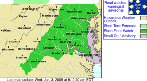
After a Tuesday evening round of strong to severe thunderstorms across Central Virginia, the chance for more severe weather and possible flash flooding exists during the afternoon and evening hours Wednesday. A Flash Flood Watch has already been posted from 12 noon until the late evening hours Wednesday.
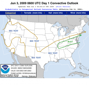

The Storm Prediction Center in Oklahoma has also placed Nelson and the surrounding area in the slight risk area for severe weather later in the day Wednesday. Afternoon heating, and plenty of moisture will provide a scenario where severe thunderstorms could develop later today.
Though not a sure bet, the potential for severe weather is better today than the average late Spring day across Central Virginia.
Continue to check our site, follow us on Twitter, or Facebook, or sign up for email alerts right from Nelson County Life Magazine to keep up with the latest developments as thunderstorms fire up this afternoon.

