Updated 12.16.08 7:30 AM
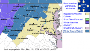
The previously issued Winter Storm Watch issue by the NWS has now been replaced by a Winter Weather Advisory that will go into effect for counties west of Nelson this evening.
Updated 10:30 PM EST 12.15.08
For the latest alert information click here to view most recent alerts from NWS.
Earlier post from Monday afternoon:
Nelson County, thus far, is not included in this Winter Storm Watch, but we are right on the line and this is a very changing situation. All of the ice we are seeing to the west in Tennessee now will advance to our area on Tuesday evening and Wednesday morning. You can always see the latest weather alerts for our area by clicking here or using the drop down menu under weather.
More over at Tommy’s Weather in tonight’s late update. Out by 12 midnight.
URGENT – WINTER WEATHER MESSAGE
NATIONAL WEATHER SERVICE BALTIMORE MD/WASHINGTON DC
359 PM EST MON DEC 15 2008MDZ004-005-009-VAZ021-025>027-029>031-042-WVZ053-160500-
/O.NEW.KLWX.WS.A.0008.081216T2300Z-081217T1600Z/
FREDERICK MD-CARROLL-MONTGOMERY-HIGHLAND-AUGUSTA-ROCKINGHAM-
SHENANDOAH-PAGE-WARREN-CLARKE-LOUDOUN-JEFFERSON-
INCLUDING THE CITIES OF…FREDERICK…WESTMINSTER…
GAITHERSBURG…STAUNTON…WAYNESBORO…HARRISONBURG…
FRONT ROYAL…LEESBURG…CHARLES TOWN
359 PM EST MON DEC 15 2008…WINTER STORM WATCH IN EFFECT FROM TUESDAY EVENING THROUGH
WEDNESDAY MORNING…THE NATIONAL WEATHER SERVICE IN STERLING VIRGINIA HAS ISSUED A
WINTER STORM WATCH…IN EFFECT FROM TUESDAY EVENING THROUGH
WEDNESDAY MORNING FOR PORTIONS OF NORTH CENTRAL MARYLAND…
NORTHERN VIRGINIA AND THE CENTRAL SHENANDOAH VALLEY.A SHALLOW…MODIFIED ARCTIC AIRMASS WILL INVADE THE MID ATLANTIC
REGION THROUGH TOMORROW. TEMPERATURES ARE EXPECTED TO FALL BELOW
FREEZING BY LATE TUESDAY AFTERNOON…AS PRECIPITATION BECOMES MORE
WIDESPREAD. ICE ACCUMULATIONS OF UP TO ONE QUARTER INCH WILL BE
POSSIBLE TUESDAY THROUGH TUESDAY NIGHT.A WINTER STORM WATCH MEANS THERE IS A POTENTIAL FOR SIGNIFICANT
ICE ACCUMULATIONS THAT MAY IMPACT TRAVEL. CONTINUE TO MONITOR THE
LATEST FORECASTS…AND BE PREPARED TO TAKE ACTION IF WARNINGS ARE
ISSUED.


A steady 30 degrees at the Mountain Inn today – will probably dip a little more before heading upward again tomorrow. Fog and drizzle all day today – not helping the snow base, but not hurting much at these temps. No ice accumulations as of 4pm but be careful out there. Looks like that massive pool of cold air is going to stay just off to the West (again!).