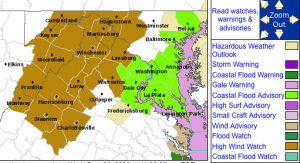

The previously issued watch has now been canceled by the NWS. There will still be some gusts to near 40 MPH from time to time.
As we have been discussing over the past day, a developing area of coastal low pressure in conjunction with high pressure over New England will create high winds Thursday. The following is information contained in the advisory by the NWS:
A HIGH WIND WATCH REMAINS IN EFFECT FROM 8 AM EDT THURSDAY
THROUGH LATE THURSDAY NIGHT.A STRONG LOW PRESSURE SYSTEM WILL MOVE INLAND FROM THE CAROLINA
COAST AS HIGH PRESSURE REMAINS OVER NEW ENGLAND. THE MID ATLANTIC
WILL BE LOCATED IN A TIGHT PRESSURE GRADIENT BETWEEN THE TWO
SYSTEMS…WHICH WILL RESULT IN SUSTAINED EASTERLY UPSLOPE WINDS
OF 40 MPH WITH BRIEF GUSTS TO 60 MPH…MAINLY ACROSS THE HIGHER
ELEVATIONS THURSDAY MORNING THROUGH THURSDAY AFTERNOON.A HIGH WIND WATCH MEANS THERE IS THE POTENTIAL FOR A HAZARDOUS
HIGH WIND EVENT. SUSTAINED WINDS OF AT LEAST 40 MPH…OR GUSTS OF
58 MPH OR STRONGER MAY OCCUR. CONTINUE TO MONITOR THE LATEST
FORECASTS FROM THE NATIONAL WEATHER SERVICE.
For complete details on this and other weather expected over the next few days, be sure to check out Tommy’s Weather from the Weather menu above, or just click here!
And always look on the upper right side of our site under the search box, for the latest RSS weather updates and / or cancellations.

