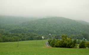
The dreary skies will more or less continue through the weekend as a frontal boundary combined with a series of disturbances affects Central Virginia’s weather until early next week. We may see a brief break on Sunday.
In the photo above, low cloud ceilings have been the norm over Rodes Farm and the mountain backdrop. Until we get a cold front through the area early next week, expect skies to remain cloudy. Though, it appears we may get a break Sunday, and if so, the sunshine will quickly warm us to near the 90° mark. All of this depends on the frontal position over the weekend.
Rainfall totals as of 11:59 PM EDT Thursday night:
–WED High / Low at NCL Magazine : Rockfish Valley : 67°/63° – RAIN : 0.04″ – YTD: 21.59″
–WED High / Low at NCL-TWNF : Wintergreen Mountain : 60°/54° – RAIN 0.06″ – YTD: 29.73″
–WED High / Low at NCL-Hatcreek Farm : Roseland, VA : 66°/61°– RAIN : 0.00″ – YTD: 28.25″
–WED High / Low at NCL-Tiger Fuel : Lovingston, VA : 66°/62° – RAIN : 0.00″ – YTD: 26.14″
–WED High / Low at NCL-Delfosse Winery : Faber, VA : 66°/62° – RAIN : 0.02″ – YTD: 21.00″
Temps haven’t moved very much with all of the damp, cloudy conditions. 60’s and low 70’s have been all the thermometer has been able to do for the past several days.
Before we update Ike below, be sure to check out the datebook below for the latest events and happenings this weekend. Many of them are winding up this weekend and won’t be back until next Spring.


Hurricane Ike continues heading for Texas. We’ll have to see what happens over the weekend as to which direction he takes. But this is a major, major hurricane threat for Texas.
Have a great Weekend!

